Camelsfoot Range facts for kids
Quick facts for kids Camelsfoot Range |
|
|---|---|

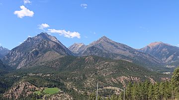
Southern ridges in the Camelsfoot Range near the Fraser River
|
|
| Highest point | |
| Peak | Red Mountain |
| Elevation | 2,445 m (8,022 ft) |
| Dimensions | |
| Area | 2,390 km2 (920 sq mi) |
| Geography | |
| Country | Canada |
| Province | British Columbia |
| Parent range | Chilcotin Ranges and Fraser Plateau |
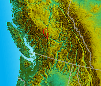
The Camelsfoot Range is a mountain range in British Columbia, Canada. It's part of the larger Coast Mountains. The mighty Fraser River runs along its eastern side. This range stretches about 90 kilometers long and is less than 30 kilometers wide.
Contents
Exploring the Camelsfoot Range
The southeastern part of the Camelsfoot Range is very rugged. It drops sharply into the deep Fraser Canyon near Fountain and Lillooet. For about 45 kilometers northwest from there, the range is rocky. It has light forests of lodgepole pine trees. You'll also find high, flat areas and large creek valleys.
Further north, the land becomes much gentler. There are high, grassy ridges that run east towards the Fraser Canyon. These are found between treed plateaus and small canyons. The range's northern and western sides are bordered by a large, impressive canyon. This canyon, formed by Churn Creek, is a protected area. The historic Empire Valley Ranch is also protected for its history and nature.
Camels in the Cariboo Gold Rush
The Camelsfoot Range got its name from a strange event during the Fraser and Cariboo Gold Rushes. A man named Frank Laumeister bought 23 camels from the US military. He used these camels to carry supplies during the gold rush. They carried goods on the Douglas Road and the Old Cariboo Road from Lillooet to Fort Alexandria. Later, they worked on the new Cariboo Wagon Road from Yale.
However, using camels didn't work out well. Horses didn't like their smell. The camels' soft feet were hurt by the rocky ground in British Columbia. Also, the handlers found them hard to manage. Many camels escaped into the wild.
The last confirmed sighting of a wild camel was near Ashcroft in 1905. Some stories claim sightings even into the 1930s. But these tales are often doubted, like stories of Sasquatch.
The original Log Cabin Theatre in Lillooet was once used as a camel barn by Laumeister. It's not known if the camels ever roamed the Camelsfoot Range itself. Today, the new highway bridge in Lillooet is called the Bridge of the Twenty-Three Camels. This name honors their unique role in local history.
The name of the Yalakom River comes from a Chilcotin word. It means the ewe (female) of the mountain sheep. The Shulaps Range, west of the Camelsfoot, is named after the Chilcotin word for the ram (male sheep).
Tall Peaks of the Range
The highest point in the Camelsfoot Range is Red Mountain, standing 2445 meters (8022 feet) tall. There have been copper mining projects on Red Mountain. Just south of Red Mountain is Poison Mountain, at 2264 meters (7428 feet). Its name comes from toxic materials in its rocks. Red Mountain's name comes from the reddish color of its copper-rich soil.
Red Mountain has a twin peak called French Mountain, which is 2231 meters (7320 feet) high. North of these is a quiet peak known as Black Dome Mountain, at 2252 meters (7388 feet). China Head (2125 meters) and Nine Mile Ridge (2422 meters) are southeast of Red Mountain. Nine Mile Ridge is a protected area. China Head's name might be linked to a local Chinese businessman from Lillooet.
South of China Head is Yalakom Mountain, 2424 meters (7953 feet) high. It's one of the tallest in the range. This area is a home for mountain sheep and other large animals. East of Yalakom Mountain is Hogback Mountain, 2149 meters (7051 feet). Its name is also connected to the hog ranch owned by the same businessman.
South of Hogback Mountain, the range becomes very rugged. Mount Birch, 2232 meters (7323 feet), is named after a former Lieutenant-Governor of British Columbia. Mount Birch has a twin peak, Mount Duncan, at 2182 meters (7159 feet). A peak overlooking the meeting point of the Yalakom and Bridge Rivers is called Mount Bishop, 1721 meters (5646 feet).
Southeast from Duncan is Slok Hill (Red Hill), 2081 meters (6827 feet). Despite its name, it's a mountain. "Slok" means "red" in the St'at'imcets language. South of Slok Hill is Camelsfoot Peak, 2014 meters (6608 feet). The Bridge River Indian Band has reserves along the lower Bridge River. Their main community is called Xwisten.
The southeastern slopes of Camelsfoot Peak overlook the town of Lillooet. The Bridge River and Fraser River meet at the southern base of the range.
Animals of the Camelsfoot
The Camelsfoot Range is home to many animals. You can find black bears, black-tail deer, moose, mountain sheep, and mountain goats. Cougars and lynx also live here. While less common than in other ranges, grizzlies can sometimes be seen.
There are no rattlesnakes in the Lillooet area. However, many types of lizards and non-venomous snakes live in the range.
Getting Around
Many high areas and peaks in the Camelsfoot Range can be reached. You can use a 4x4 vehicle, a mountain bike, or go horseback riding. The main roads go around the range. They follow the Yalakom River and Fraser River.
 | Audre Lorde |
 | John Berry Meachum |
 | Ferdinand Lee Barnett |


