Fountain, British Columbia facts for kids
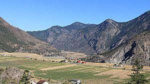
Fountain is a small, rural community and Indian reserve in British Columbia, Canada. It's located in the beautiful Fraser Canyon region, about 16 kilometers (10 miles) from the town of Lillooet. Fountain sits right on Highway 99, which is also part of the historic Old Cariboo Road. It's also where this road meets an old trail that goes through Fountain Valley and past the Fountain Lakes.
Contents
What's in a Name? The Story of Fountain
The local Indigenous name for the Fountain area in the St'at'imcets language is Cacli'p. You might also see it spelled Xaxli'p.
During the gold rush days, the area we call Fountain today was known as the Upper Fountain. A spot nearby, called Six Mile Rapids, was known as the Lower Fountain. Together, they were sometimes called "The Fountains". Over time, the name shortened to just "Fountain." The name comes from the way the Fraser River's fast-moving water and rapids look like a gushing fountain, especially at the Lower Fountain.
Exploring Fountain's Geography
Fountain is located in a unique part of the Fraser Canyon. It sits where two large cracks in the Earth's crust, the Fraser and Yalakom Faults, meet. This meeting point helped create Fountain Ridge, a natural wall that rises above the community. Fountain Ridge separates Fountain from Lillooet, which is just a few miles south.
The area around Fountain has a mix of sandy and rocky gorges. There are also flat areas called "benchlands" that were once ancient lake bottoms. These benchlands are hundreds of feet above the river. Fountain itself is partly built on one of these benchlands. The climate here is very dry. Summers can be extremely hot, sometimes even hotter than nearby Lillooet. However, winters in Fountain are much colder than Lillooet because it's at a higher elevation and is shaded by the surrounding mountains. You can find plants like sagebrush and cactus here, along with mixed coniferous forests, mostly pine trees at lower elevations.
A Glimpse into Fountain's History
People have lived in the Fountain area for thousands of years, ever since the glaciers melted away. Archeologists have found ancient "quiggly hole" villages, also known as kekuli towns, that show how people lived here long ago. One of the most important and oldest sites in British Columbia is the Keatley Creek Archaeological Site, located near Fountain.
Long ago, the Fraser River was blocked by a landslide near Texas Creek. This created a large lake that stretched past Fountain. The kekuli village at Keatley Creek was built near the shores of this ancient lake. Today, this village site is high up on a dry mountainside.
In the mid-1800s, a man named Joseph L'Italienne started a successful vineyard in Fountain. This was actually British Columbia's very first vineyard! In 1883, he sold his 160-acre (0.65 km2) land to Chief Tsil.húsalst and other members of the Fountain Band. Today, this land is part of an Indian reserve.
The Xaxli'p First Nation
The Indigenous government whose reserves are located around Fountain is the Xaxli'p First Nation. Their official name is simply "Xaxli'p." The traditional name for this place in their language is Cacli'p. The spelling Xaxli'p is an older way of writing it.
 | Jessica Watkins |
 | Robert Henry Lawrence Jr. |
 | Mae Jemison |
 | Sian Proctor |
 | Guion Bluford |


