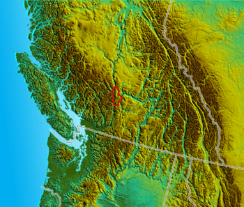
Clear Range facts for kids
Quick facts for kids Clear Range |
|
|---|---|
| Highest point | |
| Peak | Blustry Mountain |
| Elevation | 2,334 m (7,657 ft) |
| Dimensions | |
| Area | 2,123 km2 (820 sq mi) |
| Geography | |
| Country | Canada |
| Province | British Columbia |
| Parent range | Fraser Plateau |
The Clear Range is a mountain range in south-central British Columbia, Canada. It sits where the Fraser River and Thompson River meet. This range is part of a larger group called the Pavilion Range.
The Clear Range covers about 16,270 square kilometers (6,280 square miles). It stretches 75 kilometers (47 miles) from north to south. At its widest, it is 35 kilometers (22 miles) from east to west. A smaller part of it, called the Scarped Range, is just northeast of where the two rivers join.
This mountain range is next to the Marble Range. Both ranges line the east bank of the Fraser River. They are north of the town of Lytton, British Columbia. The Clear Range reaches up to the town of Pavilion. Its northern edge is the south wall of Marble Canyon.
To the southeast, the Thompson River forms a border between Ashcroft and Lytton. Northeast of the range are the Cornwall Hills and Trachyte Hills. Beyond them are the Arrowstone Hills. The Clear Range is shaped like a horseshoe. It faces the Hat Creek basin. This basin is a high plateau with rangeland. All these areas are part of the Fraser Plateau, which is inside the Interior Plateau.
Contents
Exploring the Terrain of Clear Range
The Clear Range has very steep sides. This is especially true near the Fraser River. Here, the northern peaks are high plateau edges. They rise almost 2,000 meters (7,000 feet) above the river.
The middle of the range is rugged. It has many valleys that connect in complex ways. You might find Karst formations here. These suggest there could be caves, but none have been found yet. There are also many waterfalls that appear and disappear. You can also find sub-alpine swamps. The northern border of the Clear Range is the south wall of Marble Canyon.
Highest Peaks in the Range
The tallest mountains in the Clear Range are impressive.
- Blustry Mountain is the highest at 2,334 meters (7,657 feet).
- Its neighbor, Cairn Peak, is 2,328 meters (7,638 feet) tall.
- North of these, Moore Peak reaches 2,223 meters (7,293 feet).
- Chipuin Mountain is 2,170 meters (7,119 feet) high.
In the southern part of the range, Botanie Mountain is the highest. It is just north of Lytton and stands 2,077 meters (6,814 feet) tall. Closer to the center of the range, Mount Murray is 2,153 meters (7,064 feet) high.
There is also a separate ridge called Fountain Ridge. It is across the Fraser River from Lillooet. This ridge is geologically different. It is a thin piece of land between two large fault lines. Arthur Seat is on this ridge. It is 1,672 meters (5,486 feet) tall. A pioneer named John Murray named it after a mountain in Edinburgh, Scotland.
Wildlife and Plants of Clear Range
The climate in the Clear Range changes a lot. It is mostly dry, especially on the west and southeast sides. However, the inner parts of the range get more rain. These areas are heavily covered with trees.
You can find typical forest and mountain animals here. This includes grizzly bears and black bears. You might also see black-tail deer and moose. Various rodents also live in the area. The range is home to different types of dryland lizards. It also has the timber rattlesnake. The Clear Range is the farthest northwest place where these rattlesnakes live.
History and Human Impact
The Clear Range is mainly the home of the Nlaka'pamux people. However, the northwest edge of the range is used by communities of the St'at'imc people. A community of the Secwepemc people also lives at Marble Canyon. Their land includes the southeastern part of the range along the Thompson River.
There are no big towns or cities directly in the Clear Range. But three major highways and three rail lines run along its edges. These include the BCR, CPR, and CNR.
The Clear Range was important during the Fraser Canyon Gold Rush and Cariboo Gold Rush. It overlooked the paths where many gold seekers traveled. However, no major gold mines were found on its slopes. At the northern end of the range, there is a large deposit of low-quality coal. This coal is near Marble Canyon and the Hat Creek basin. There have been plans to build a large open-pit coal mine and a power plant here.
The area is used for logging, which means many trees are cut down. Because of this, there are many logging roads and trails. These trails are popular for outdoor activities. People enjoy them for 4x4 vehicles, mountain biking, and other recreation.
See also
In Spanish: Cordillera Clear para niños
 | Isaac Myers |
 | D. Hamilton Jackson |
 | A. Philip Randolph |


