Cariboo Mountains facts for kids
Quick facts for kids Cariboo Mountains |
|
|---|---|

Peaks in the Premier Range
|
|
| Highest point | |
| Peak | Mount Sir Wilfrid Laurier |
| Elevation | 3,516 m (11,535 ft) |
| Dimensions | |
| Length | 245 km (152 mi) SE-NW |
| Width | 90 km (56 mi) SW-NE |
| Area | 7,700 km2 (3,000 sq mi) |
| Geography | |
| Country | Canada |
| Province | British Columbia |
| Range coordinates | 52°55′N 120°15′W / 52.917°N 120.250°W |
| Parent range | Columbia Mountains |
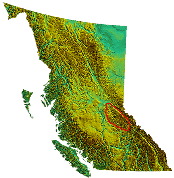
The Cariboo Mountains are a large mountain range in British Columbia, Canada. They are the most northern part of the Columbia Mountains, which stretch south into the United States. Other famous parts of the Columbia Mountains include the Selkirks and Monashees. The Cariboo Mountains cover a huge area, about 7,700 square kilometers. They are about 245 kilometers long and 90 kilometers wide.
Contents
Exploring the Cariboo Mountains' Geography
The Cariboo Mountains are surrounded by interesting landforms. To the east, you'll find the Rocky Mountain Trench. This is a long valley where the upper Fraser River flows. Part of this river is called the Grand Canyon of the Fraser.
To the west, the mountains meet the Cariboo Plateau. This area has rolling hills and is known as the Quesnel Highland. Further northwest, the mountains become lower near the Willow River and Prince George. South of the range, near Clearwater, there's a mountainous area that connects to the Shuswap Highland.
Some people used to think the Cariboo Mountains were part of the Cariboo Plateau. However, these mountains are very large and have peaks as high as other major ranges. Because of their size and height, they are definitely considered a true mountain range.
Rivers and Waterways in the Cariboo Mountains
The Cariboo Mountains are unique because most of their water flows into the Fraser River. This is different from other parts of the Columbia Mountains, which often feed the Columbia River. The North Thompson River is also an important river that gets water from these mountains. There's a small exception with the Canoe River, which flows into the Rocky Mountain Trench.
Highest Peaks and the Premier Range
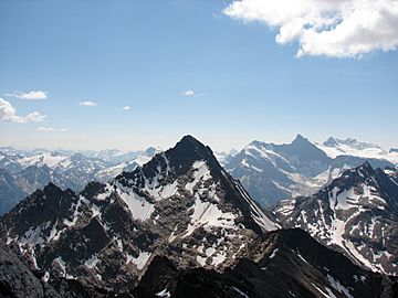
The tallest mountains in the Cariboo range are found in a special group called the Premier Range. Many of these peaks are named after important leaders. Eleven peaks are named after Canadian Prime Ministers. One peak is named after a British Prime Minister. Another is named after a Premier of British Columbia.
The highest peak in the entire range is Mount Sir Wilfrid Laurier. It stands tall at 3,516 meters (11,535 feet). A more recently named peak in this group is Mount Pierre Elliott Trudeau.
Outside of the Premier Range, the highest peak is Quanstrom Mountain. It reaches 3,038 meters (9,967 feet) and is the most northern peak in the range that is over 3,000 meters high.
Parts of the Cariboo Mountains
The Cariboo Mountains are made up of several smaller mountain groups, called sub-ranges. These include:
- Mowdish Range
- Premier Range
- Wavy Range
Parks and Protected Areas in the Cariboo Mountains
A large part of the Cariboo Mountains is protected land. This helps keep the natural environment safe for animals and plants.
- Wells Gray Provincial Park: This park was created in 1939 and is the fourth largest provincial park in British Columbia. It covers a big section of the Cariboo Mountains.
- Bowron Lake Provincial Park: This park is very popular for canoeing. It's located east of Barkerville, a historic town from the Cariboo Gold Rush.
- Cariboo Mountains Provincial Park: This park is located between Wells Gray and Bowron Lake parks, adding more protected land to the area.
See also
 In Spanish: Montañas Cariboo para niños
 | William L. Dawson |
 | W. E. B. Du Bois |
 | Harry Belafonte |


