
Wells Gray Provincial Park facts for kids
Quick facts for kids Wells Gray Provincial Park |
|
|---|---|
|
IUCN Category Ib (Wilderness Area)
|
|

Helmcken Falls
|
|
_location_map.svg)
Wells Gray Provincial Park
Location in British Columbia
|
|
| Location | British Columbia, Canada |
| Nearest city | Clearwater |
| Area | 541,516 ha (2,090.80 sq mi) |
| Established | November 28, 1939 |
| Visitors | 3.5 million day-trippers (in 2003) |
| Governing body | BC Parks |
Wells Gray Provincial Park is a huge wilderness park in east-central British Columbia, Canada. It protects most of the southern and highest parts of the Cariboo Mountains. The park covers 5,250 square kilometres (about 1.3 million acres). It is British Columbia's fourth largest park.
Contents
Park Landscape and Features
Wells Gray Park includes most of the area where the Clearwater River gets its water. Most of the water in the park flows into this river. The northern two-thirds of the park is very rugged. It has high mountains and deep valleys carved by glaciers.
The land here ranges from Clearwater Lake at 680 metres (2,230 feet) high to an unnamed peak at 2,946 metres (9,665 feet). These tall peaks are part of the Cariboo Mountains. Many valleys have large lakes like Clearwater, Azure, and Hobson. This wild northern part of the park is mostly explored by experienced backpackers.
The southern part of Wells Gray Park is easier to reach by road. This area has volcanic plateaus, old lava flows, and deep canyons. Several peaks here are over 2,300 metres (7,500 feet) tall. The park is famous for its many waterfalls. These waterfalls often formed when volcanoes erupted and glaciers moved. Helmcken Falls is the most famous. It is Canada's fourth highest waterfall, plunging 141 metres (463 feet) down.
Tallest Mountains in Wells Gray
Here are the eight tallest mountains in Wells Gray Park:
Unnamed Peak (Mount Lyons), 2946 m
This is the park's highest mountain, but it doesn't have an official name. It is very remote. The first people to climb it are unknown. Bill McKenzie and Roger Wallis made the second climb in 2005.
Mount Goodall, 2930 m
This mountain has 11 different peaks and stretches for almost 8 km (5 miles). A huge wall of rock and ice rises from the Goodall Glacier. The first climb was in 2006 by Roger Wallis, Don Chiasson, and Jim Lundy. This mountain is named after Trooper Walter Henry Goodall. He was a Canadian soldier who died in World War II.
Garnet Peak, 2876 m
You can see Garnet Peak from many places in the southern part of Wells Gray Park. It is north of Azure Lake. Hugh Neave, Tor Schmid, and Barbara Hargreaves first climbed it in 1974. For a long time, people thought it was the park's highest mountain.
Unnamed Peak, 2861 m
This is the second highest peak in the Goodall group. It is sometimes called "The Black Cone." Paul Geddes, Norm Greene, and Bill McKenzie first climbed it in 2012.
Mount Pierrway, 2854 m
Art Maki and Art Wilder first climbed Mount Pierrway in 1969. It is named after Private Alfred Pierrway, another soldier who died in World War II.
Unnamed Peak, 2847 m
This peak is on the northern edge of the park. As of 2015, no one has recorded climbing this mountain. This makes it Wells Gray Park's highest unclimbed mountain.
Mount Hugh Neave, 2829 m
This mountain is east of Hobson Lake. It is named after Hugh Neave, who was the first to climb Garnet Peak. He tried to climb this mountain in 1972 but couldn't reach the top.
Unnamed Peak, 2797 m
This peak is southeast of Mount Beaman.
Park History
Before Europeans arrived, the Wells Gray area was important hunting land for Indigenous peoples. These included the Secwepemc (Shuswap), Tsilhqot'in (Chilcotin), and Canim Lake people. There was a conflict around 1875 over hunting caribou. Names like "Battle Mountain" and "Fight Lake" remind us of this time.
In 1862, explorers called "Overlanders" floated down the North Thompson River. They noticed how clear the Clearwater River was, so they named it "Clear Water." In 1863, the first tourists, Lord Milton and Dr. Cheadle, traveled through the area. They wrote about the Clearwater River, making its name official.
Between 1872 and 1881, many groups surveyed British Columbia. They were looking for the best route for the Canadian Pacific Railway. Three groups visited what is now Wells Gray Park. They explored lakes and river sources, but the routes were too difficult for a railway. In 1881, a different route was chosen, and these plans were dropped. Only a few place names in the park remember these surveys, like Murtle River and Mahood River.
Robert Lee, a land surveyor, discovered Helmcken Falls in 1913. He was so amazed that he asked the Premier of British Columbia, Sir Richard McBride, to name the falls after him. But the Premier decided to name them Helmcken Falls instead. This honored John Sebastian Helmcken, a doctor who helped British Columbia join Canadian Confederation in 1871. Dr. Helmcken never saw the falls himself.
The first settlers in Wells Gray Park arrived around 1911 and 1912. They built cabins and lived far from other people. More settlers came between 1918 and 1925.
In 1926, a huge forest fire destroyed much of the Clearwater Valley. It started from lightning and spread quickly. Many settlers lost their homes and belongings. One family hid in Battle Creek for 8 hours to escape the flames. Luckily, no one died in the fire.
People started suggesting a park to protect Helmcken Falls soon after its discovery. In the 1930s, more people pushed for a park. Finally, Arthur Wellesley Gray, the Minister of Lands, became interested in creating parks. In 1939, he created a large park around the Clearwater River area. He named it Wells Gray Park after himself.
In 2018, a very large cave called Sarlacc's Pit was discovered in the park. Its entrance is huge, about 100 by 60 metres (330 by 200 feet). A 61-metre (200-foot) waterfall flows into the pit.
Clearwater River and Dam Plans

A big flood on the Fraser River in 1948 almost changed the Clearwater River and Wells Gray Park forever. After the flood, a committee was formed to study the Fraser River's water. They looked at ways to generate power, control floods, and manage water.
In the 1950s, there were ideas to build dams on the Clearwater River. Some proposals suggested two dams. In 1959, a plan was made to develop power from the Murtle River.
The biggest plan came in 1963. It suggested building seven dams and five reservoirs on the Clearwater River. These dams would turn the river into a 160 km (100-mile) long series of lakes. The dam at Sabre Tooth Rapids would be the highest, flooding much of Helmcken Canyon. It would even cover the bottom 10 metres (33 feet) of Helmcken Falls.
At that time, people were not very concerned about losing remote wilderness areas. The British Columbia government was also busy building other large dams. So, the Clearwater River dam plans were not acted upon.
In 1971, BC Hydro, the provincial power company, looked at the dam plans again. But by then, people cared more about protecting the environment. Groups like the Yellowhead Ecological Association organized bus tours of Wells Gray Park. Guides asked people to imagine the valley flooded by dams. This created a lot of protest. Within a year, the plan to dam the Clearwater River was stopped. BC Hydro gave up its water rights in 1987.
Park Nature and Animals

Wells Gray Park has many different types of land, which makes it very diverse. It is home to over 700 kinds of plants, more than 200 types of mushrooms, 56 kinds of mammals, and 219 kinds of birds.
Many things help make the park so rich in life. These include the 1926 forest fire, and the different areas surrounding the park. Inside the park, small climate differences, altitude, soil, and water availability all help create this wide variety of plants and animals. The park has thick forests of conifer trees. Areas above 1,900 metres (6,200 feet) have large alpine meadows.
Park Wildlife
This park is home to many birds. It also has mammals like grizzly bears, white-tailed deer, beavers, moose, mule deer, black bears, and timber wolves.
Park Climate
Winters in the Clearwater Valley are cold. There is usually about 1 metre (3 feet) of snow at lower elevations, and much more higher up. Snow can stay on the roads until mid-April. It never completely melts from the north sides of the mountains.
Early May and most of June are often rainy. During the summer, storms happen about once a week. Clearwater gets about 43 cm (17 inches) of rain each year. This amount increases as you go north into the park. Clearwater Lake gets over 60 cm (24 inches) of rain, and Azure Lake gets about 80 cm (31 inches).
Summer temperatures in the Clearwater Valley are often around 20-25 degrees Celsius (68-77 degrees Fahrenheit). They can reach 30 degrees Celsius (86 degrees Fahrenheit). Temperatures change a lot depending on how high up you are. September through mid-October usually has clear, warm days, cool nights, and colorful fall leaves.
How to Get to Wells Gray Park
There are five roads that lead into Wells Gray Park.
- Clearwater Valley Road: This is the main road for visitors. It starts from the Yellowhead Highway in Clearwater and goes 68 km (42 miles) north to Clearwater Lake. Most of the park's popular spots are along this road. These include Spahats Falls, Trophy Mountain, Moul Falls, Dawson Falls, and Helmcken Falls. The first part of the road is paved, then it becomes a good gravel road.
- Clearwater River Road: This road follows the west side of the Clearwater River for 37.9 km (23.5 miles). It leads to places like The Kettle and Sabre Tooth Rapids. Rafting companies use this road to access the river. It is a rough road, so a vehicle with high clearance is suggested.
- Mahood Lake Road: This road starts from Highway 24. It is 127.7 km (79.3 miles) long and ends at Deception Point on Mahood Lake. There is a campground at Mahood Lake. You can see Canim Falls and enjoy the beaches here. Most of this road is gravel.
- Murtle Lake Road: This road starts at Blue River on the Yellowhead Highway. It climbs for 27 km (17 miles) to a pass. A short trail from there leads to Murtle Lake. Murtle Lake is North America's largest lake where only paddling is allowed (no motorboats). The road is rough, so a high-clearance vehicle is recommended.
- Flourmill Volcanoes Road: This road starts at 100 Mile House. It is 97.1 km (60.3 miles) long and mostly gravel and dirt. From the end of the road, it's a 3.7 km (2.3 miles) hike to the lava flow.
Fun Things to See and Do
The park is popular from mid-May to mid-October. Campgrounds are open during this time. The park is open all year, but in winter, the main road is only plowed to Helmcken Falls. Here are some of the park's main attractions:
- Helmcken Falls: This is the park's biggest attraction. It's Canada's fourth highest waterfall, dropping 141 metres (463 feet). You can hike to different viewpoints, including the top and bottom of the falls. In winter, a huge ice cone forms at the base.
- Spahats Falls: This 60-metre (200-foot) waterfall is on Spahats Creek. It drops into the Granite Canyon of the Clearwater River.
- Trophy Mountain: This mountain range is on the south edge of the park. Its meadows are beautiful with wildflowers in late June and late July to early August. There are many hiking trails here.
- Third Canyon: You can safely view two waterfalls and an 80-metre (260-foot) deep gorge from the road bridge here.
- Moul Falls: This 35-metre (115-foot) waterfall is on Grouse Creek. It's a popular short hike, and it's the only waterfall where you can walk behind the water.
- Green Mountain: You can drive to the top of Green Mountain. A viewing tower offers amazing views of the southern part of Wells Gray Park.
- Dawson Falls: This waterfall is on the Murtle River, about 5 km (3 miles) upstream from Helmcken Falls. It is 20 metres (66 feet) high and 90 metres (300 feet) wide.
- The Mushbowl: This is a narrow canyon downstream from Dawson Falls. The Clearwater Valley Road crosses the Murtle River here. You can see some of Wells Gray Park's oldest rocks.
- Ray Farm: This is an old, abandoned farm. John Ray lived here from 1911 to 1947 with his wife and three children.
- Baileys Chute: This is a small waterfall on the Clearwater River. In late summer and fall, you can see salmon trying to jump up the falls.
- Clearwater Lake: This is where the Clearwater Valley Road ends. There are two large campgrounds here. Osprey Falls is a small waterfall where the lake flows into the Clearwater River. You can take boat tours or rent boats to explore Clearwater Lake and Azure Lake.
- Murtle Lake: This is a wilderness lake in the southeast part of the park. It's only for canoes and kayaks.
- Canim Falls: These falls are in the far western part of the park, reached by Mahood Lake Road. The Canim River flows over a 25-metre (82-foot) high lava cliff.
- Mahood Lake: This lake is reached from the west. It has a campground and a beach. The lake is 21 km (13 miles) long.
Wells Gray Park Waterfalls
Wells Gray Park is known as "Canada's Waterfalls Park" because it has 39 named waterfalls. There are many more smaller ones! Here is a list of the named waterfalls:
| Waterfall Name | Height in metres | Location |
|---|---|---|
| Allison | 15 | Philip Creek below Philip Lake |
| Are | 15 | Philip Creek above confluence with Trout Creek |
| Baileys Chute | 10 | Clearwater River above The Horseshoe |
| Candle Creek | 10 | Candle Creek near Clearwater River |
| Canim | 25 | Canim River between Canim and Mahood Lakes |
| Coal Creek | 40 | Coal Creek in the Hemp Canyonlands |
| Cougar | 20 | Cougar Creek falling into Helmcken Canyon |
| Crystal | 30 | Unnamed creek flowing into north side of Azure Lake |
| Dawson | 20 | Murtle River |
| Deception | 50 | Deception Creek above Mahood Lake |
| Fage | 30 | Fage Creek near Clearwater River |
| Falls Creek | 4 | Confluence of Falls Creek and Clearwater River |
| Garnet | 30 | Garnet Creek above Azure Lake |
| Goodwin | 10 | Mahood River below Sylvia Falls |
| Helmcken | 141 | Murtle River |
| Hemp | 8 | Hemp Creek west of The Flatiron |
| Horseshoe | 6 and 10 | Murtle River |
| Ida | 20 | Third Canyon Creek near Buck Hill |
| Lifely | 10 | Unnamed creek flowing into east side of Clearwater Lake |
| Mahood | 20 | Unnamed creek, part of Canim River outflow from Canim Lake |
| Majerus | 12 | Murtle River |
| Marcus | 5 | Clearwater River above Baileys Chute |
| McDiarmid | 10 | Grouse Creek near confluence with Clearwater River |
| McDougall | 14 | Murtle River below Murtle Lake |
| Meadow | 8 | Murtle River below McDougall Falls |
| Moul | 35 | Grouse Creek above confluence with Clearwater River |
| Mushbowl | 5 | Murtle River at Clearwater Valley Road bridge |
| Myanth | 3 | Clearwater River above Marcus Falls |
| Osprey | 3 | Clearwater River at mouth of Clearwater Lake |
| Rainbow | 20 | Angus Horne Creek above Azure Lake |
| Roostertail | 10 | Unnamed creek flowing into south side of Azure Lake |
| Second Canyon | 15 | Second Canyon Creek below Clearwater Valley Road |
| Silvertip | 200 | Silvertip Creek above Spahats Creek Road |
| Spahats | 75 | Spahats Creek near confluence with Clearwater River |
| Sticta | 10 | Falls Creek 1 km upstream from Clearwater River |
| Sundt | 25 | Lickskillet Creek near Hobson Lake |
| Sylvia | 20 | Mahood River 3.5 km above Clearwater River |
| Third Canyon | 8 and 10 | Third Canyon Creek above Clearwater Valley Road |
| Triple Decker | 60 | Candle Creek below Clearwater Valley Road |
Campgrounds in and Near the Park
| Campground name | # of sites | What's there |
|---|---|---|
| Clearwater Lake | 39 | Located at Km 65 on Clearwater Valley Road. Has RV dump, showers, outhouses, running water, a small store, and talks by naturalists. Very popular in summer, so reservations are a good idea. |
| Falls Creek | 41 | Located at Km 64.7 on Clearwater Valley Road. Shares facilities with Clearwater Lake campground. Has outhouses and running water. Also very popular in summer. |
| Pyramid | 50 | Located at Km 42 on Clearwater Valley Road. Has outhouses and a hand-pump for water. It's usually not full, but there can be many mosquitoes. |
| Mahood Lake | 34 | Near the end of Mahood Lake Road. Has outhouses, running water, a playground, a boat launch, and a sandy beach. Reservations are taken. |
| North Thompson | 61 | On the Yellowhead Highway, 5 km (3 miles) south of Clearwater (not inside Wells Gray Park). Has RV dump, outhouses, running water, and a playground. Reservations are taken. |
Images for kids
-
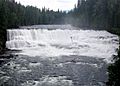
Dawson Falls on the Murtle River
-
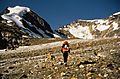
Mount Hugh Neave (centre) from Hobson Glacier
-
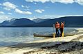
West Arm of Murtle Lake
-
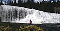
Osprey Falls on Clearwater River
-
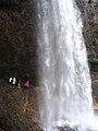
Hikers behind Moul Falls
-
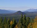
Pyramid Mountain from Green Mountain
-
Sylvia Falls on Mahood River


