
Helmcken Falls facts for kids
Quick facts for kids Helmcken Falls |
|
|---|---|
.jpeg)
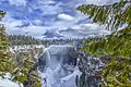
Helmcken Falls in Wells Gray Provincial Park
|
|
| Lua error in Module:Infobox_mapframe at line 185: attempt to index field 'wikibase' (a nil value). | |
| Location | Wells Gray Provincial Park, British Columbia, Canada |
| Coordinates | 51°57′15″N 120°10′37″W / 51.954092°N 120.176911°W |
| Type | Plunging Punchbowl |
| Total height | 141 m (463 ft) |
| Number of drops | 1 |
| Total width | 23 m (75 ft) |
| Average width | 15 m (49 ft) |
| Watercourse | Murtle River |
| Average flow rate |
107 m3/s (3,800 cu ft/s) |
Helmcken Falls is a huge and beautiful waterfall in Wells Gray Provincial Park in British Columbia, Canada. It drops an amazing 141 m (463 ft)! That's taller than a 40-story building!
This powerful waterfall is on the Murtle River. Protecting Helmcken Falls was a big reason why Wells Gray Provincial Park was created way back in 1939.
Helmcken Falls is actually the fourth highest waterfall in all of Canada. It's measured by how far the water falls straight down without any breaks. Other taller waterfalls in British Columbia include Hunlen Falls, Takakkaw Falls, and Della Falls.
The Murtle River has six other waterfalls upstream from Helmcken Falls. These include The Mushbowl, Dawson Falls, Majerus Falls, Horseshoe Falls, Meadow Falls, and McDougall Falls. You can reach Helmcken, The Mushbowl, and Dawson Falls by road. The others need a bit of a hike to see. Meadow Falls is super hard to see unless you're flying above it!
Contents
Who Discovered Helmcken Falls?
Railroad surveyors in the 1870s didn't mention seeing the falls. So, the credit for finding Helmcken Falls goes to Robert Henry Lee. He was a land surveyor working for the British Columbia government.
In 1911, Lee got a job to survey lands in the North Thompson and Clearwater Valleys. By 1913, he was marking out land for settlers south of the Murtle River. On July 24, 1913, he walked along the Murtle River from his camp. He then reached the top of the amazing waterfall.
Lee was so impressed that he wrote a letter to Sir Richard McBride. McBride was the Premier of British Columbia at the time. Lee asked for the falls to be named "McBride Falls" after him.
Just three weeks later, Lee got a reply from the Premier. The letter said the waterfall would be called Helmcken Falls instead. This name honored John Sebastian Helmcken. He was a doctor who worked for the Hudson's Bay Company. Dr. Helmcken arrived in Victoria in 1850. He helped British Columbia join Canadian Confederation in 1871. Dr. Helmcken passed away in 1920 when he was 95 years old. Sadly, he never actually got to see the falls himself.

Visiting Helmcken Falls and Its Trails
It's easy to get to Helmcken Falls! A short paved road from the main Wells Gray Park road leads right to it. There's a special viewing platform on the edge of the canyon. From here, you can see a fantastic view of the falls and the canyon around it.
Brink Trail: Get Close to the Edge!
There's a 4-kilometer long trail that starts near Dawson Falls. This trail follows the south bank of the Murtle River. It leads you right to the very edge, or "brink," of Helmcken Falls. This walk takes about 1 hour and 15 minutes each way. Be super careful at the end of this trail! There are no fences, so watch out, especially with kids and pets.
Helmcken Canyon: A River Meeting Point
You can take a 30-minute walk west from the main viewpoint. This path follows the rim of Helmcken Canyon. It leads to a spot where you can see the Murtle and Clearwater Rivers meet. This meeting point is about 250 m (820 ft) below you!
Gattling Gorge Trail: A Narrow River Spot
Gattling Gorge is the narrowest part of the Clearwater River. It's only about 20 m (66 ft) wide! This gorge is at the top of Helmcken Canyon. It's upstream from where the Murtle River joins the Clearwater. There's a trail from the main Helmcken Falls viewpoint that goes to this gorge. However, the signs aren't very good. This hike takes about 1 hour and 30 minutes each way.
Winter Wonderland at Helmcken Falls

Most people visit Helmcken Falls in the summer. But a winter visit is really special! A huge ice cone often forms at the bottom of the falls. It can grow up to 50 meters tall! In very cold, snowy winters, it can even reach halfway up the falls.
The best time to see this amazing ice cone is from late January to the end of February. The cone usually starts to break apart sometime in March. You can still see some parts of it even in June. The road to the falls is cleared of snow and sanded in winter. Volunteers also help keep the trails open. If you visit in winter, make sure your car has snow tires. Tire chains are also a good idea for safety.
How Helmcken Falls Was Formed
Helmcken Falls drops over the edge of the Murtle Plateau. This plateau is a huge area made of hardened lava. This lava came from volcanoes in the Wells Gray-Clearwater volcanic field. The lava started flowing about 200,000 years ago. It filled up the wide valley of the Clearwater River, layer by layer.
After the lava created the plateau, huge floods happened. These floods were at the end of the last ice age, about 10,000 years ago. These powerful floods carved out Helmcken Canyon below the falls.
Images for kids
-
Helmcken Falls with the ice cone
.jpg)
