Hunlen Falls facts for kids
Quick facts for kids Hunlen Falls |
|
|---|---|
 |
|
| Lua error in Module:Infobox_mapframe at line 185: attempt to index field 'wikibase' (a nil value). | |
| Location | Tweedsmuir South Provincial Park, British Columbia, Canada |
| Coordinates | 52°16′36″N 125°46′21″W / 52.2768°N 125.7724°W |
| Type | Plunge |
| Total height | 260 m (850 ft) |
| Number of drops | 1 |
| Longest drop | 260 m (850 ft) |
| Total width | 24 m (79 ft) |
| Average width | 30 m (98 ft) |
| Run | 15 m (49 ft) |
| Watercourse | Hunlen Creek |
| Average flow rate |
4 m3/s (140 cu ft/s) |
| World height ranking | 118th (by tallest single drop) |
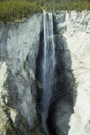
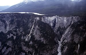
Hunlen Falls is an amazing waterfall in British Columbia, Canada. It's found at the end of Turner Lake in the Pacific Ranges mountains. This waterfall is super tall, dropping about 260 meters (850 feet)! That makes it one of the tallest single-drop waterfalls in Canada, tied with Takakkaw Falls. It's a truly spectacular sight to see.
Contents
What's in a Name?
The name "Hunlen Falls" came about in 1947. It was named after a Chilcotin Chief called Hana-lin. He used to fish below the falls in the autumn. He would also set up traps for game nearby. Before 1947, the falls had other names. In the 1930s, some people called it "Mystery Falls." Even earlier, it was sometimes known as "Bella Coola Falls."
How Hunlen Falls Was Formed
Hunlen Falls drops 260 meters (850 feet) straight down. The water comes from the north end of Turner Lake. This water flows through a stream called Hunlen Creek. The creek then empties into the Atnarko River. The Atnarko River is a smaller river that flows into the Bella Coola River. Over time, the water has worn away the canyon below the falls. This erosion has created a fan-shaped area of sediment. This area is called an alluvial fan.
How to Visit Hunlen Falls
There isn't a road that goes directly to Hunlen Falls. The easiest way to get there is by taking a float plane. These planes land on water. You can catch a float plane from Nimpo Lake. The flight takes about 20 minutes. The plane will land on Turner Lake, which is above the falls. From there, a good trail leads to a viewpoint. The walk to the viewpoint takes about 30 minutes. The viewpoint is on the east side of the canyon. There are no fences, so be careful!
You can also hike to Hunlen Falls. The hiking trail starts from Highway #20. This is at the bottom of the Bella Coola Hill. A road called the Tote Rd offers 4x4 vehicle access. This road leads to the start of the hiking trail. The trail itself is about 16 kilometers (10 miles) long. BC Parks and volunteers help keep the trail clear. They also maintain the path to Turner Lake.
Nearby Places to Explore
About 2 kilometers (1.2 miles) east of Turner Lake is Lonesome Lake. This lake runs next to Turner Lake. It is shaped like an "S" and is almost 12 kilometers (7.5 miles) long. You can even see Lonesome Lake from the cliffs at Hunlen Falls. The south end of Lonesome Lake was once a homestead. A pioneer named Ralph Edwards lived there. His home was called "The Birches." He lived there from 1912 into the 1970s. A famous book called Crusoe of Lonesome Lake tells his story.
In July 2004, lightning started a fire. It struck the ridge between Turner and Lonesome Lake. This fire became known as the Atnarko fire. It burned through August. The fire burned the southern side of Turner Lake. It also reached the falls. Sadly, it destroyed several homes, including the Edwards and Turner homesteads.
 | Jessica Watkins |
 | Robert Henry Lawrence Jr. |
 | Mae Jemison |
 | Sian Proctor |
 | Guion Bluford |


