Murtle River facts for kids
Quick facts for kids Murtle River |
|
|---|---|

|
|
| Country | Canada |
| Province | British Columbia |
| Physical characteristics | |
| Length | 36 km (22 mi) |
| Basin features | |
| River system | Clearwater River |
| Waterbodies | Murtle Lake |
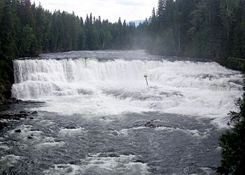
| Waterfalls | McDougall, Meadow, Horseshoe, Majerus, Dawson, The Mushbowl and Helmcken Falls |
The Murtle River is a river located in the east-central part of British Columbia, Canada. It starts high up in the Cariboo Mountains from a large glacier, about 2,300 meters (7,500 feet) above sea level. From there, it flows southwest for about 18 kilometers (11 miles) until it reaches the huge Murtle Lake.
After leaving Murtle Lake, the river continues its journey southwest for another 36 kilometers (22 miles). It then joins the Clearwater River. The Murtle River is the longest and largest river that flows into the Clearwater River. It is especially famous for its many beautiful waterfalls.
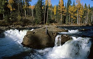
Between Murtle Lake and the Clearwater River, the Murtle River tumbles over seven named waterfalls. These include McDougall, Meadow, Horseshoe, Majerus, Dawson, The Mushbowl, and Helmcken Falls.
Contents
How the Murtle River Got Its Name
We don't have any old records about what First Nations people called the Murtle River. The river was first explored and named by a surveyor named Joseph Hunter. He was working for the company that would later build the Canadian Pacific Railway.
On May 25, 1874, Hunter's team rafted across the Clearwater River. They traveled east for about 13 kilometers (8 miles) and found the Murtle River. Hunter named the river and, a few days later, Murtle Lake after his hometown in Scotland, Milton of Murtle.
Searching for a Railway Route
Between 1872 and 1881, many survey teams explored British Columbia. They were trying to find the best path for the new railway from Yellowhead Pass in the Rocky Mountains to the Pacific Ocean. Three of these teams visited the area that is now Wells Gray Park.
However, in 1881, a different route through Kicking Horse Pass was chosen instead. This meant all the detailed routes explored by Hunter and others were not used. Only three places in the park still carry names from these railway surveys: Murtle River and Lake, Mahood River and Lake, and Marcus Falls. These last two are named after James Adam Mahood and Marcus Smith, who led other railway surveys.
Discovering Helmcken Falls
It took 40 years for people to professionally survey the Murtle River area again. In 1913, a land surveyor named Robert Lee was working there. He was marking out plots of land near the Murtle River when he discovered Helmcken Falls.
Lee was so amazed by the waterfall that he wrote a letter to Sir Richard McBride, who was British Columbia's leader at the time. Lee asked if he could name the river and the falls after McBride. But Joseph Hunter had already named the Murtle River. Three weeks later, Lee received a short reply from McBride saying the waterfall should be called Helmcken Falls. The letter didn't mention the McBride River, so Lee continued to use Murtle River on his maps.
Bridges Over the Murtle River
The Murtle River has been crossed by bridges at its narrowest point, known as The Mushbowl. The very first crossing was a shaky footbridge built in 1914. In 1928, a bridge for horses was completed. It was very basic, with no guard rails, and horses were often scared to cross it.
This horse bridge was damaged by high water in 1936 and then replaced. In 1940, Arthur Wellesley Gray, for whom Wells Gray Park is named, almost fell off this bridge because he felt dizzy. He nearly became the first person to have an accident at The Mushbowl.
The first road bridge was built in 1949 when the road was extended to Clearwater Lake. This bridge, a Queen's Truss bridge, was very attractive and many visitors stopped to take photos. It lasted until 1974. Today, a narrow Bailey-type bridge stands in the same spot. The Murtle River still roars through The Mushbowl underneath it. This is still the only bridge that crosses the Murtle River along its entire length.
Geological Features of the Murtle River Area
For the last 30 kilometers (19 miles) of its journey to the Clearwater River, the Murtle River flows across a huge flat area called the Murtle Plateau. This plateau was formed about 200,000 years ago when lava erupted from cracks in the ground near McLeod Hill. The lava filled the old river valley, sometimes as deep as 250 meters (820 feet). You can best see how flat this area is from the viewing tower on top of Green Mountain.
Pyramid Mountain
Pyramid Mountain is a noticeable landmark next to the Murtle River. It's a few kilometers northeast of the main road. This mountain is a special type of volcano called a subglacial mound. It formed about 12,000 years ago when lava erupted under a thick sheet of ice, building its 250-meter (820-foot) high cone.
Helmcken Canyon
Below Helmcken Falls, the Murtle River rushes through a narrow gorge called Helmcken Canyon. This canyon is about 1.5 kilometers (0.9 miles) long and has steep lava walls that rise over 200 meters (660 feet) on both sides. The river flows through this deep canyon until it meets the Clearwater River.
 | Sharif Bey |
 | Hale Woodruff |
 | Richmond Barthé |
 | Purvis Young |


