Murtle Lake facts for kids
Quick facts for kids Murtle Lake |
|
|---|---|
| Location | British Columbia |
| Coordinates | 52°9′00″N 119°40′00″W / 52.15000°N 119.66667°W |
| Primary inflows | Murtle River, File Creek, Anderson Creek, Strait Creek |
| Primary outflows | Murtle River |
| Basin countries | Canada |
| Max. length | 30 km (19 mi) |
| Max. width | 1 km (0.6 mi) to 4 km (2.5 mi) |
| Max. depth | 300 m (984 ft) |
| Surface elevation | 1,067 m (3,501 ft) |
| Islands | 3 |
| Settlements | None |
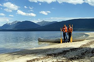
Murtle Lake is a special lake located in Wells Gray Provincial Park in British Columbia, Canada. It was formed long ago when lava blocked a river. The lake is mainly fed by the Murtle River, which starts from a large glacier high in the Cariboo Mountains. After leaving the lake, the Murtle River continues its journey to the Clearwater River.
Murtle Lake has a unique shape, like a backwards 'L' with two main parts, called arms. The North Arm stretches deep into the Cariboo Mountains, looking like a fjord. The West Arm is very popular because it has wide sandy beaches, many hidden coves, and three islands. Mountains like the Wavy Range and Central Mountain surround the lake.
In 1968, a large part of Wells Gray Park, including Murtle Lake, became a protected area. This means it's kept safe from too much building or changes. Two years later, in 1970, motorboats and airplanes were banned from the lake. Today, Murtle Lake is the biggest lake in North America where only canoes and kayaks are allowed. This makes it a very peaceful place to visit.
Contents
Getting to Murtle Lake
The only way to reach Murtle Lake is by driving 27 km (16.8 mi) on a road that turns off the Yellowhead Highway near Blue River. The road ends at the edge of Wells Gray Park, close to Phyllis Lake.
Portaging to the Lake
From the end of the road, visitors need to carry their canoe or kayak for 2.5 km (1.6 mi) to reach the Murtle Lagoon. This path is wide and mostly flat, so many people use a special cart to roll their boat instead of carrying it. If you don't have a canoe, you can walk another 1.5 km (0.9 mi) along the north shore of Murtle Lagoon. This walk leads to a big sandbar where you can get a great view of Murtle Lake.
Camping at Murtle Lake
There are 19 special campsites with 66 spots along the lake's shore. Visitors are only allowed to camp in these designated areas. It's a good idea to check the BC Parks rules before you visit to make sure you know all the regulations.
Exploring Trails Around the Lake
Several trails start from the lakeshore, letting you explore more of the area. These include trails to McDougall Falls, File Creek, McDougall Lake, Anderson Lake, Central Mountain, Henrietta Lake, Strait Lake, and the Wavy Range. You can find detailed descriptions of these trails and where they start in the book Exploring Wells Gray Park.
History and How Murtle Lake Got its Name
The first time Murtle Lake was officially seen and recorded was on May 27, 1874. This was done by Joseph Hunter, a surveyor working for the future Canadian Pacific Railway.
Hunter's Discovery
Hunter's team crossed the Clearwater River and traveled east. They reached the Murtle River upstream from Majerus Falls. Hunter named the Murtle River, and then Murtle Lake a few days later, after his hometown in Scotland, Milton of Murtle, near Aberdeen.
Hunter wrote about his discovery in his diary. He described the river becoming a lake and how they crossed it on a raft. He noted the mountains around the lake, describing them as "bold, high and rugged" to the north, and "steep but not rough" to the south, leaving flat ground along the shore.
Hunter's team explored around Murtle Lake for four days. They then left through a low pass to the east and reached the North Thompson River near Blue River on June 2.
Railway Surveys and Place Names
Between 1872 and 1881, many survey teams explored British Columbia. They were trying to find the best path for the new railway from the Yellowhead Pass in the Rocky Mountains to the Pacific Coast. Three of these survey teams visited the area that is now Wells Gray Park.
However, in 1881, a different route through the Kicking Horse Pass was chosen for the railway. This meant all the detailed routes explored by Hunter and others were not used. Only a few place names in Wells Gray Park today remind us of those ten years of surveys. These include Murtle River and Lake, Mahood River and Lake, and Marcus Falls. These names honor the leaders of those early railway surveys.
 | Stephanie Wilson |
 | Charles Bolden |
 | Ronald McNair |
 | Frederick D. Gregory |


