
Clearwater River (British Columbia) facts for kids
Quick facts for kids Clearwater River |
|
|---|---|

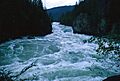
Clearwater River viewed from Whitehorse Bluffs
|
|
| Country | Canada |
| Province | British Columbia |
| Physical characteristics | |
| Main source | Cariboo Mountains 1,356 m (4,449 ft) 52°49′N 120°6′W / 52.817°N 120.100°W |
| River mouth | North Thompson River 392 m (1,286 ft) 51°37′59″N 120°4′50″W / 51.63306°N 120.08056°W |
| Length | 201 km (125 mi) |
| Basin features | |
| Basin size | 10,200 km2 (3,900 sq mi) |
| Waterfalls | Baileys Chute, Marcus Falls, Myanth Falls, Osprey Falls |
The Clearwater River is a major river in British Columbia, Canada. It's the biggest river that flows into the North Thompson River. The two rivers meet near the town of Clearwater, British Columbia.
The Clearwater River starts high up in the Cariboo Mountains from melting glaciers. It flows south for about 201 kilometers (125 miles). Almost its entire journey is inside Wells Gray Provincial Park. Where it meets the North Thompson River, the area is protected by North Thompson River Provincial Park.
Two large lakes are part of the Clearwater River system. Hobson Lake is about 35 km (22 mi) long. Further downstream, Clearwater Lake is 24 km (15 mi) long. The river also has many smaller streams joining it, like the Azure River and Murtle River.
People love the Clearwater River for outdoor activities. It's a great spot for fly fishing, whitewater kayaking, and whitewater rafting. Many visitors also enjoy hiking and watching wildlife along its banks.
Contents
River's Story: How Clearwater Got Its Name
Early Explorers and a Clear Name
In 1862, a group of explorers called the Overlanders traveled down the North Thompson River. When they reached the mouth of this river, they noticed how clear its water was. It was very different from the muddy North Thompson. So, they simply called it "Clear Water."
A year later, in 1863, two early tourists, Lord Milton and Dr. Cheadle, explored the area. They wrote about their travels and published the name "Clear Water River." This helped make the name official.
The Clearwater River gets its clear water because it flows through large lakes. These lakes, like Hobson Lake and Clearwater Lake, act like giant filters. They let the silt and mud from the glaciers settle out. This makes the water sparkling clear. Other rivers in the area, like the North Thompson, don't have these natural filters, so their water stays muddy.
Searching for Gold and Silver
In the late 1800s, people started looking for valuable minerals along the Clearwater River. Miners found signs of silver in 1866. Later, in 1869, Chinese miners were working along the river, finding gold. They used water to wash the gravel and find the gold.
In 1899, a prospector named H.R. Bellamy suggested that the Clearwater River likely carried a lot of gold. This sparked more interest in mining. By the 1920s, many areas along the river were being explored for gold and silver.
One interesting mining site was the Blue Ice Mine. It was located very high up in the mountains, near a glacier. Even though it had good amounts of gold and silver, it was too hard to develop. The glacier nearby moved too much, making it dangerous.
Railway Plans That Changed Course
Between 1872 and 1881, railway companies explored British Columbia. They were looking for the best route for a new railway across Canada. Several survey teams visited the Clearwater River area. They hoped to find an easy path through the mountains.
One surveyor, Marcus Smith, thought a route through Clearwater Lake might work. Another team, led by E.W. Jarvis, explored the river's source. They found a high pass near a huge glacier. It was "clearly impracticable" for a railway. In the end, a different route was chosen far to the south. The railway plans for the Clearwater River basin were abandoned.
Early Settlers: The Ray Family Homestead

No one built homes right next to the Clearwater River because the land wasn't good for farming. However, John Ray settled about 55 km (34 mi) up the Clearwater Valley in 1911. He lived far from anyone else.
John cleared land and grew most of his own food. He also trapped animals for furs, which he traded for supplies. He lived alone for many years. In 1932, at age 54, he married Alice Ludtke, who was 20. They raised three children in this remote home.
In 1946, the family decided to move to Clearwater. They wanted their children to go to school. John made many trips to move their belongings. Sadly, he died of a heart attack on his last trip in December 1947. Today, the old Ray Farm buildings are falling apart, but you can still hike to the site.
Exploring the River's Landscape

The Clearwater River flows through two very different types of landscapes. The first part of the river is in the Cariboo Mountains. Here, you'll see deep valleys carved by glaciers. The river starts from a glacier, surrounded by tall peaks. Some of these mountains, like Mount Goodall and Mount Hugh Neave, are among the highest in Wells Gray Park. They were named after Canadian soldiers who died in World War II.
The river then flows into Hobson Lake. Below the lake, the Clearwater drops over several small waterfalls and many rapids. It falls 178 meters (584 ft) in just 12 km (7.5 mi). After the Azure River joins it, the Clearwater becomes easier to navigate. It then flows into Clearwater Lake. East of the lake, you can see Mount Ray, a volcano that erupted about 20,000 years ago.
The second half of the Clearwater River is shaped by volcanoes. Here, you'll find lava plateaus and cliffs along the riverbanks. Clearwater Lake itself was formed by a lava flow about 7,600 years ago.

The river leaves Clearwater Lake by dropping over Osprey Falls. This creates a dangerous spot for boats. For the next 65 km (40 mi), the Clearwater rushes through many rapids and over three more waterfalls: Myanth Falls, Marcus Falls, and Baileys Chute. Some exciting whitewater sections include Gattling Gorge and Granite Canyon.
One unique part of the river is called The Horseshoe. It's a 5 km (3 mi) long bend where the river almost forms a complete circle. East of the river, you can see mountains like Battle Mountain, Trophy Mountain, and Raft Mountain.
Getting to the Clearwater River
There are two main roads that let you explore the Clearwater River area.
Clearwater Valley Road
This road is also known as Wells Gray Park Road. It starts from the Yellowhead Highway in Clearwater and goes north. It follows the east side of the Clearwater Valley for 68 km (42 mi) to Clearwater Lake. Most visitors to Wells Gray Park use this road. It leads to popular spots like Spahats Falls, Helmcken Falls, and Clearwater Lake.
For the first 49 km (30 mi), this road is either high above the river or a few kilometers away. So, you'll need to use hiking trails to reach the river itself. The road is paved to Helmcken Falls, then becomes a good gravel road to Clearwater Lake.
- Trails from Clearwater Valley Road:*
- Triple Decker Falls (at 4.3 km from Yellowhead Highway)
- Bottom of Spahats Falls (at 10.2 km)
- First Canyon (at 13.2 km)
- Canyon Creeks (at 17.1 km)
- These four trails connect to the Clearwater River Trail, which runs along the east side of the river.
- Moul Falls (at 20.7 km)
- Flatiron and Hemp Canyonlands (at 29.4 km)
- Green Mountain and White Horse Bluff (at 36.2 km)
- Helmcken Falls side road, then trail to Gattling Gorge (at 42.5 km)
- The Horseshoe (at 52.5 km)
- Baileys Chute, Marcus Falls and Myanth Falls (at 57.1 km)
- Norman's Eddy (at 64.2 km)
Clearwater River Road
This road also starts in Clearwater but goes north along the west bank of the river. It's about 38 km (24 mi) long and ends where the Mahood River joins the Clearwater. This road is often right next to the river. Sometimes, in May or June, it might close due to high water.
This road is usually rough and slow, so a vehicle with good ground clearance is recommended. You can find exciting rapids like The Kettle (at 8.0 km) and Sabre Tooth Rapids (at 21.1 km) from this road. At the end of the road, a trail leads to Sylvia Falls on the Mahood River.
Fishing in the Clearwater River

The Clearwater River is home to many types of fish. You can find Kokanee, Chinook salmon, Coho salmon, Sockeye salmon, Rainbow trout, Dolly Varden, and Mountain whitefish. Thousands of salmon come to the river to spawn (lay their eggs) each year.
Baileys Chute is a great place to watch Chinook salmon. From mid-August through September, you can see these large salmon trying to leap up the falls. Chinook salmon are the biggest of the Pacific salmon, weighing from 8 kg to 22 kg (18 to 49 lbs).
The Clearwater River used to be famous for amazing fishing in the 1940s. Fishing camps were built, and people from all over the world came to fish. However, after the Clearwater River Road was built, it became too easy to access the river. This led to too many fish being caught, and the river became almost empty of fish for about 30 years.
To help the fish population recover, new rules were put in place in 1994. These rules include:
- Catch and release (you must let the fish go).
- A ban on using bait.
- Using only a single barbless hook.
- No fishing before July 15 each year.
It took about 10 years for the fishing to improve, but these rules are still enforced today. These special rules apply only to the Clearwater River downstream from Clearwater Lake.
Boating Adventures

The Clearwater River is a popular spot for different kinds of boating.
Whitewater Rafting
Several companies offer whitewater rafting trips on the Clearwater River. You can experience exciting sections like Sabre Tooth Rapids and Granite Canyon. These trips are a thrilling way to see the river's powerful rapids.
Kayaking
Kayaking on the Clearwater River requires expert skills for many parts. If you're new to the river, it's best to try it when the water levels are low to medium, usually in July, August, or September. The Clearwater River Road gives access to about 30 km (19 mi) of the river.
Some of the most exciting sections for kayakers are Sabre Tooth Rapids, Batholith Rapids, and the 8 km (5 mi) run through Granite Canyon. Only a few very skilled kayakers have dared to go through The Kettle, which is rated as extremely difficult.
Between Clearwater Lake and Deer Creek, many parts of the river can be reached from the Clearwater Valley Road. You'll need to carry your kayak around Marcus Falls and Baileys Chute. Myanth Falls is also a challenging spot. The Horseshoe is the longest calm section of the river. After Deer Creek, there are 10 km (6 mi) of intense rapids, including Gattling Gorge and Helmcken Canyon.
Canoeing
For canoeists, the only safe section downstream from Clearwater Lake is around The Horseshoe. You can put your canoe in at Alice Creek and take it out at Deer Creek, both accessible from the Clearwater Valley Road.
Upstream, between Azure Lake and the upper end of Clearwater Lake, canoeing downstream is safe. However, the current is too strong to paddle upstream, so a portage trail is available.
Cool Facts About the Clearwater River
- Only One Meander: Most rivers with bends have many of them. But the Clearwater River has only one big bend, called The Horseshoe.
- Waterfalls on Tributaries: Every major stream that flows into the Clearwater River has a waterfall on it! Falls Creek Falls even drops directly into the Clearwater.
- Protected Shoreline: A huge 97% of the Clearwater River's shoreline is protected by Wells Gray Provincial Park. This helps keep the river wild and beautiful.
- Private Properties: There are only two private properties along the Clearwater River inside Wells Gray Park. One used to be a private fishing spot for a famous industrialist. The other is a wilderness cabin you can rent.
- White Horse Bluff and Rock Roses:

White Horse Bluff is a tall cliff that rises 200 meters (656 ft) straight up from the river's east bank. On its south side, you can see a rare volcanic formation called the Rock Roses. Instead of looking like organ pipes, these rock columns are horizontal, like tiles on a wall.
- Natural Refrigerator: At the base of White Horse Bluff, there's a natural refrigerator! The McDiarmid family, who ran fishing camps, found a cold draft coming from cracks in the rock. They made it into a cool storage area. Even today, it stays very cold inside, like a natural fridge in the wilderness.
- Abandoned Donkey Engine: In the forest near Marcus Falls, there's an old, abandoned donkey engine. This is a heavy machine used for logging. It was brought there in 1912-13 for a planned railway bridge. However, the railway route changed, and the 10-ton machine was left behind. You can sometimes see it from a viewpoint when the leaves are off the trees.
Images for kids
-
The Kettle in Granite Canyon

