Trophy Mountain facts for kids
Quick facts for kids Trophy Mountain |
|
|---|---|

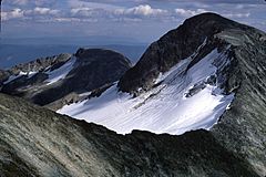
Highest summit of Trophy Mountain seen from West Summit
|
|
| Highest point | |
| Elevation | 2,577 m (8,455 ft) |
| Geography | |
| Parent range | Shuswap Highland |
| Topo map | 82M/13 or PS-WG3 (south half) |
| Geology | |
| Mountain type | Pyramidal peak |
| Climbing | |
| Easiest route | Via West Summit and West Ridge |
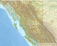
Trophy Mountain is a cool mountain in British Columbia, Canada. People sometimes call it the Trophy Mountains or The Trophies. It's located in the southeast part of Wells Gray Provincial Park. Rivers like the Clearwater River and Raft River flow nearby.
Trophy Mountain is part of the Shuswap Highland. It has nine different peaks, and the tallest one is 2,577 m (8,455 ft) high! Other mountains like Raft Mountain are close by. A hunting guide named Dan Case gave Trophy Mountain its name.
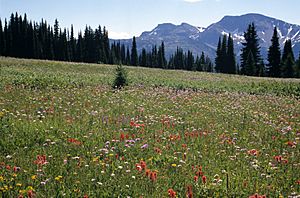
This mountain is easy to get to by road and trail. It's a popular spot for visitors in the summer. People especially love its colourful alpine meadows, which are like natural flower gardens high up in the mountains. You can find many hiking paths here, especially around Sheila Lake.
Contents
Getting to Trophy Mountain
To reach Trophy Mountain, you'll take the Trophy Mountain Road. It turns east off the Clearwater Valley Road, about 11.3 km (7.0 mi) north of the Yellowhead Highway. The gravel road is a bit steep and bumpy, but most cars can use it. It's about 13 km (8.1 mi) long to the parking lot.
From the parking lot, a clear trail leads you up. You'll climb about 300 m (984 ft) through some trees to reach the open alpine meadows. This easy hike is about 3.1 km (1.9 mi) long and takes about 75 minutes. You'll reach an old shepherd's hut along the way.
As you hike, you'll see amazing views of Raft Mountain to the south. In late July and early August, the meadows are full of bright flowers. You might even see glacier lilies blooming earlier, in late June. The trail continues past the hut for another 30 minutes to the Sheila Lake Lookout.
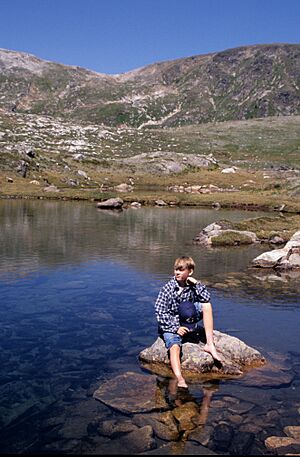
From this viewpoint, you can see Sheila Lake and a "Plateau of Lakes" with many small ponds. You can also spot four of the nine Trophy Mountain peaks! Raft Mountain and Dunn Peak are visible to the south.
If you like to camp, there are simple campsites and an outhouse near Sheila Lake. The main trail ends here, but you can explore more of the meadows. You can hike on Trophy Mountain from late June through September.
History of Trophy Mountain
The old shepherd's hut you see on the mountain was built in the 1950s. Brothers John and Frank Ronacher used it when they brought their sheep to graze in the Trophy meadows. Back then, the only way up was a rough trail.
Later, in 1962, Emil and Ida DeKelver bought the sheep business. They started with 100 sheep and soon had 300! The rich grasslands of Trophy Mountain were perfect for their herd.
However, in 1969, the government made it harder for people to graze animals. So, the DeKelvers changed their business. They started guiding people and offering trail rides on the Trophy Mountains. They even built a new, shorter trail up Spahats Creek.
In 1979, logging began on Trophy Mountain, and new roads were built. This made it hard for the DeKelvers' guiding business, so they retired. Today, the old shepherd's hut is slowly falling apart due to the weather. Soon, there might be no sign of the days when hundreds of sheep lived in these meadows.
Wells Gray Park was first created in 1939. Trophy Mountain was added to the park in 1997, protecting its beautiful alpine areas.
Mountain Geology
Most of Trophy Mountain is made of very old rock called the Shuswap Metamorphic Complex. This rock stretches across British Columbia. About 100 million years ago, another type of rock, called the Raft Batholith, pushed into it.
During the Ice Ages, huge glaciers carved out Trophy Mountain. They created many bowl-shaped areas now filled with lakes. They also formed the rugged north face of the mountain, which is 700 m (2,297 ft) high.
Long ago, between 500,000 and 300,000 years ago, lava flowed from cracks on the west side of Trophy Mountain. This lava built up in the Clearwater Valley. You can still see signs of volcanoes here. There's a small volcano cone called Buck Hill on Trophy Mountain. There might even be a water-filled volcanic crater at the start of Third Canyon Creek.
Wells Gray Park's most southern glacier is on the north side of Trophy Mountain. You can see it from the West Summit.
Fun Hikes and Climbs
There are many great hikes and climbs you can do on Trophy Mountain! Here are a few popular ones:
- Long Hill: This is the westernmost peak, at 2,343 m (7,687 ft) high. It takes about 2 hours to hike there from Sheila Lake.
- West Summit: This peak is 2,532 m (8,307 ft) high. It's about a 2-hour hike from Sheila Lake, passing by the Lake of the Rock. From here, you can see Garnet Peak and even Mount Robson, the tallest mountain in the Canadian Rockies!
- Trophy Skyline: This is a fantastic hike with amazing views. It connects the West Summit and Long Hill. The whole trip from Sheila Lake takes about 5 hours.
- Trophy Summit: This is a tougher hike to the main summit. It takes about 12 hours round trip from the parking lot, or 9 hours from Sheila Lake. You'll go via the West Summit and then a narrow ridge.
- East Ridges: You can drive to the Spahats Creek Valley to start this hike. An unmarked trail takes about 2 hours to reach the meadows. A longer hike goes to the East Summits and Wolverine Basin, taking about 6 hours round trip.
 | Selma Burke |
 | Pauline Powell Burns |
 | Frederick J. Brown |
 | Robert Blackburn |


