
Wells Gray-Clearwater volcanic field facts for kids
Quick facts for kids Wells Gray-Clearwater volcanic field |
|
|---|---|

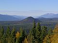
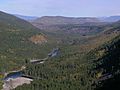
A view from Green Mountain with Pyramid Mountain in the distance
|
|
| Highest point | |
| Elevation | 2,100 m (6,900 ft) |
| Geography | |
| Location | British Columbia, Canada |
| Parent range | Quesnel Highland/Shuswap Highland/Cariboo Mountains |
| Geology | |
| Age of rock | Pliocene-to-Holocene |
| Mountain type | Monogenetic volcanic field |
| Last eruption | 1550 (?) |
The Wells Gray-Clearwater volcanic field is a special area in east-central British Columbia, Canada. It's about 130 kilometers (80 miles) north of Kamloops. This area is full of many small volcanoes and wide lava flows. It's called a monogenetic volcanic field because each volcano erupts only once.
Most of this volcanic field is inside a big park called Wells Gray Provincial Park. This park is huge, covering 5,405 square kilometers (2,087 square miles). It was created in 1939 to protect amazing places like Helmcken Falls and the unique Clearwater River area. You can drive on five roads into the park to see some of these volcanic spots. Short walks lead to other cool features. Some areas can only be reached by plane.
Contents
How the Volcanoes Formed: Geology Basics
Ancient Eruptions: The Ice Age (Pleistocene Epoch)

Volcanic activity here started a very long time ago, during the early Pleistocene Ice Age. This was about 2.6 million years ago! Scientists know this by using special dating methods like radiocarbon dating and potassium-argon dating. These early eruptions created huge lava flows that filled valleys and covered plateaus. Imagine 25 cubic kilometers (6 cubic miles) of lava!
These lava flows happened during at least three different ice ages. You can still see proof of this today. For example, there are flat-topped volcanoes called tuyas, which formed when lava erupted under thick ice. When magma pushed into the ice, it melted a vertical hole. The lava then cooled into a large block with a flat top. Some tuyas, like Gage Hill and Mosquito Mound, show signs of being worn down by glaciers. This tells us they erupted during the early Ice Age.

One amazing underwater volcano formed during the Ice Age. It's called White Horse Bluff. Scientists think it formed in three steps. First, it erupted into water, probably a lake created by glacial ice in the Clearwater River valley. The hot lava caused violent steam explosions. These explosions broke the lava into tiny pieces. These pieces then settled in the water, forming a rock called hyaloclastite. This makes White Horse Bluff look different from other volcanoes. The eruption stopped once the volcano reached the surface of the water.

Other volcanic events happened when hot magma met groundwater. This created many pit craters, which are like big holes. Many of these holes later filled with water, forming beautiful crater lakes. In some places, you can find old soil layers (called paleosols) buried under the lava flows. Most of the volcanic rocks are covered by a thick layer of glacial dirt called till. So, you mostly see the rocks where cliffs have formed in valleys.
Newer Eruptions: After the Ice Age (Holocene Epoch)

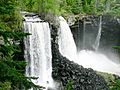
About 10,000 years ago, the last Ice Age ended. Huge floods from melting glaciers carved deep canyons into the old lava flows. Rivers like the Murtle and Clearwater now flow through these canyons. You can see stunning waterfalls like Canim Falls, Moul Falls, Spahats Falls, and the 141-meter (463-foot) high Helmcken Falls. The cliffs of these waterfalls are made of columnar basalt. This is a type of rock that shrinks as it cools, forming cool vertical columns.
More recently, the southern part of the volcanic field has had continuous volcanic activity since the Ice Age ended. This happened in three areas: Spanish Creek, Ray Lake, and Kostal Lake. These eruptions created cinder cones (cone-shaped hills made of volcanic ash and rock) and new lava flows.
In the Spanish Creek and Ray Lake areas, volcanoes erupted while glaciers were still around, and continued after the ice melted. Two cinder cones, Flourmill Cone and Pointed Stick Cone, formed in the Spanish Creek area. Their lava flows sit directly on glaciated rock, meaning they are quite young, from the early Holocene epoch (the last 10,000 years).
Near Ray Lake, the Dragon Cone cinder cone was built. Its eruption ended with a 16-kilometer (10-mile) long lava flow called "Dragon's Tongue." This flow is about 7,600 years old. It's at least 15 meters (49 feet) thick at the start and thins to 3 meters (10 feet) at the end. It even dammed the southern part of Clearwater Lake. You can still see molds of trees in the lava flow where it cooled around them.
The most recent eruption created a small, tree-covered cinder cone at the east end of Kostal Lake, called Kostal Cone. This might have happened as recently as 400 years ago! This makes it one of Canada's youngest volcanoes.
Why Do These Volcanoes Exist?

The Wells Gray-Clearwater volcanic field started forming about 3.5 million years ago. It has been growing ever since. Scientists are still studying exactly why these volcanoes are here. It's about 250 kilometers (155 miles) inland from another volcanic area called the Garibaldi Volcanic Belt.
The rocks from the Wells Gray volcanoes are mostly a type of basalt called alkali olivine basalt. Some lava flows even contain pieces of the Earth's deep interior, called mantle xenoliths. These are like clues that help scientists understand what the Earth's mantle is made of.
Scientists once thought these volcanoes were part of the Anahim Volcanic Belt. However, the way they are spread out doesn't quite fit. Newer studies suggest that a deep crack in the Earth's crust, called the Nootka Fault, might be causing these volcanoes. This crack allows hot rock from deep inside the Earth to rise up and melt, creating magma.
What is the Lava Made Of?

Some of the lava flows in the Wells Gray-Clearwater area are special because they contain small, green rock pieces called nodules. These nodules and crystals come from the Earth's mantle. These green nodules are mostly made of a mineral called olivine, which is rich in magnesium and iron. The lava also has large crystals of olivine, plagioclase, and pyroxene. These crystals formed deep inside the Earth's crust and mantle. By studying these nodules, volcanologists can learn about what the Earth's mantle looks like beneath the volcanic field.
The newer lava flows (from the Holocene epoch) are more "alkalic" than the older ones. They also contain different types of xenoliths, like chromium-spinel lherzolite. The older lava flows don't have these xenoliths. However, chemical tests show that all the lava flows formed in a similar way. They came from the upper mantle, which slowly became less rich in certain elements after each melting event.
Is the Volcanic Field Still Active?
The Wells Gray-Clearwater volcanic field is one of 10 volcanic areas in Canada that have had recent seismic activity (small earthquakes). This suggests that these volcanoes still have active magma systems deep underground. This means they could erupt again in the future. While we don't have all the answers, these signs show that some of Canada's volcanoes are potentially active. This means there could be dangers from them. In areas with many small volcanoes, like Wells Gray-Clearwater, the earthquakes seem more spread out. Sometimes, earthquakes happen in groups, which could be a sign of volcanic activity.
What are the Dangers? Volcanic Hazards
Lava Eruptions

Because the Wells Gray-Clearwater volcanic field is in a remote area, the danger from lava eruptions would be low to medium. Lava that doesn't have much silica (like basalt) can flow for tens of kilometers (miles) from the volcano. On steep slopes, the front of a lava flow can move as fast as 10 kilometers per hour (6 miles per hour). But on gentle slopes, it usually moves less than 1 kilometer per hour (0.6 miles per hour). If lava flows are stuck in a channel or lava tube on a steep slope, they can reach speeds of over 30 kilometers per hour (19 miles per hour).
Based on past activity, the Wells Gray-Clearwater volcanic field usually has quiet eruptions. These are like lava fountains, where glowing hot cinders, small rocks (lapilli), and lava bombs are shot into the air. These eruptions are usually small to medium in size. Since the area is mostly forest, lava flows could start large forest fires. They might also block some river valleys.
Explosive Eruptions
More violent eruptions are possible only in special situations, like if a volcano erupts into a lake. Any future eruption would likely only affect a small area downhill from the volcano. Volcanic gases are also a danger. These gases are trapped in the magma and lava, or they come from groundwater heated by the volcano. The most dangerous volcanic gases are sulfur dioxide, carbon dioxide, and hydrogen fluoride. Locally, sulfur dioxide gas can cause acid rain and air pollution downwind from the volcano.
Watching the Volcanoes: Monitoring
Currently, the Geological Survey of Canada doesn't watch the Wells Gray-Clearwater volcanic field closely enough. We don't know exactly how active its magma system is. The existing network of seismographs (machines that detect earthquakes) is set up to watch for regular earthquakes. They are too far away to give a good idea of what's happening under the volcanic field. They might detect a big increase in activity, but this might only give a warning for a very large eruption. It might even detect activity only after the volcano has already started erupting.

One way to guess when an eruption might happen is to study the volcano's past. Every volcano has its own way of erupting. Its future eruptions are usually similar to its past ones. But this is hard to do for Wells Gray-Clearwater because it's so far away from cities.
Canada needs a better plan for watching its volcanoes. We need to know more about the types, sizes, and how often these dangers happen. This information is not detailed enough for volcanoes in British Columbia or other parts of Canada.
Other ways to study volcanoes include hazard mapping. This shows a volcano's past eruptions and helps predict future dangers. Right now, there are no hazard maps for the Wells Gray-Clearwater volcanic field. We just don't know enough about it because it's so remote. The Geological Survey of Canada has never had a large program just for volcanic hazards. Most of the information we have has been gathered slowly by different volcanologists and other geologic scientists. We know the most about the Mount Meager massif. We are also learning more about Mount Cayley. It would be helpful to quickly check the dangers at all young Canadian volcanoes. This would help decide which areas need more study.

The network of seismographs for regular earthquakes has been around since 1975. But it didn't have many sensors until 1985. Except for a few short tests by the Geological Survey of Canada, no volcano monitoring has been done at Wells Gray-Clearwater or other Canadian volcanoes like in other countries with active volcanoes. Active volcanoes are usually watched with at least three seismographs. These are placed within 15 kilometers (9 miles), and often within 5 kilometers (3 miles), of the volcano. This helps detect small earthquakes and pinpoint their location and depth. This kind of monitoring helps predict eruptions, which is important for keeping people safe.
Currently, the closest seismograph to the Wells Gray-Clearwater volcanic field is 59 kilometers (37 miles away). When seismographs are farther away and there are fewer of them, it's harder to predict eruptions. This is because the location and depth of earthquakes are less accurate. However, at least one possible volcanic earthquake swarm (a group of small earthquakes) has been noticed east of the Wells Gray-Clearwater volcanic field. The earthquake locations in the Wells Gray-Clearwater volcanic field can be off by a few kilometers. In more remote northern areas, they can be off by up to 10 kilometers (6 miles). The smallest earthquakes that can be detected in Wells Gray-Clearwater are about magnitude 1 to 1.5. In other places, it's magnitude 1.5 to 2. At volcanoes that are watched closely, all detected earthquakes are recorded and studied right away. This helps understand future eruptions. In British Columbia, small earthquakes are not always recorded or studied right away.
In countries like Canada, small earthquake swarms that happen before an eruption might not be detected. Even if larger swarms are detected, it's hard to be sure if they are volcanic or if they belong to a specific volcano.
Cool Volcanic Spots: Notable Vents
| Name | Height | Coordinates | Type | Age of last eruption | |
|---|---|---|---|---|---|
| metres | feet | ||||
| Quesnel Lake | 1292 | 4239 | 52°39′N 120°59′W / 52.65°N 120.98°W | Cinder cone | Pleistocene |
| Kostal Cone | 1440 | 4724 | 52°10′N 119°56′W / 52.17°N 119.94°W | Cinder cone | Holocene |
| Pillow Creek | 1829 | 6001 | 52°01′N 119°50′W / 52.02°N 119.84°W | Subglacial volcano | Pleistocene |
| Gage Hill | 1090 | 3576 | 52°03′N 120°01′W / 52.05°N 120.01°W | Tuya | Pleistocene |
| Dragon Cone | 1850 | 6070 | 52°15′N 120°01′W / 52.25°N 120.02°W | Cinder cone | Holocene |
| Flourmill Cone | 1495 | 4905 | 52°03′N 120°19′W / 52.05°N 120.32°W | Cinder cone | Holocene |
| Pointed Stick Cone | 1820 | 5971 | 52°14′N 120°05′W / 52.24°N 120.08°W | Cinder cone | Holocene |
| Spanish Lake Centre | 1770 | 5807 | 52°04′N 120°19′W / 52.07°N 120.31°W | Cinder cone | Holocene |
| Spanish Bonk | 1770 | 5807 | 52°08′N 120°22′W / 52.13°N 120.37°W | Volcanic neck | Pleistocene |
| Ray Mountain | 2050 | 6726 | 52°14′N 120°07′W / 52.24°N 120.11°W | Subglacial mound | Pleistocene |
| Spanish Mump | 1800 | 5906 | 52°10′N 120°20′W / 52.16°N 120.33°W | Subglacial mound | Pleistocene |
| Jack's Jump | 1895 | 6217 | 52°07′N 120°03′W / 52.12°N 120.05°W | Subglacial volcano | Pleistocene |
| Hyalo Ridge | 2012 | 6601 | 52°07′N 120°22′W / 52.11°N 120.36°W | Tuya | Pleistocene |
| McLeod Hill | 1250 | 4101 | 52°01′N 120°01′W / 52.02°N 120.01°W | Tuya | Pleistocene |
| Mosquito Mound | 1065 | 3494 | 52°01′N 120°11′W / 52.02°N 120.18°W | Tuya | Pleistocene |
| Buck Hill | 1585 | 5200 | 51°05′N 119°59′W / 51.08°N 119.98°W | Cinder cone | Pleistocene |
| Ida Ridge | 1981 | 6499 | 51°05′N 119°56′W / 51.08°N 119.94°W | Cinder cone | Pleistocene |
| Fiftytwo Ridge | 1996 | 6549 | 51°56′N 119°53′W / 51.93°N 119.89°W | Subglacial volcano | Pleistocene |
| Flatiron | 730 | 2395 | 51°53′N 120°03′W / 51.88°N 120.05°W | Volcanic outcrop | Pleistocene |
| White Horse Bluff | 831 | 2726 | 51°05′N 120°07′W / 51.09°N 120.11°W | Subaqueous volcano | Pleistocene |
| Pyramid Mountain | 1095 | 3593 | 51°59′N 120°01′W / 51.99°N 120.01°W | Subglacial volcano | Pleistocene |
Images for kids
-
A view from Green Mountain with Pyramid Mountain in the distance
-
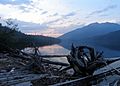
Clearwater Lake, a lake formed by ancient lava in the Wells Gray-Clearwater volcanic field
-
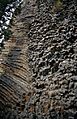
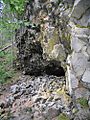
Rock Roses formation on the south side of White Horse Bluff
-
Osprey Falls drops over the lava dam at the outlet of Clearwater Lake
-
Canim Falls and lava flows
-
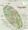
Map of the Wells Gray-Clearwater volcanic field
-
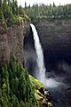
Helmcken Falls and the deposits of volcanic rock
-
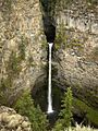
Spahats Falls and deposits of volcanic rock
-
Columnar basalt of the Dragon's Tongue lava flow
-
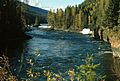
Clearwater Valley
