Kostal Lake facts for kids
Quick facts for kids Kostal Lake |
|
|---|---|

Lake and Kostal Volcano
|
|
| Location | British Columbia |
| Coordinates | 52°09′50″N 119°58′34″W / 52.164°N 119.976°W |
| Primary inflows | minor creeks |
| Primary outflows | Kostal Creek to File Creek to Murtle Lake |
| Basin countries | Canada |
| Max. length | 4.5 km (2.8 mi) |
| Max. width | 2.7 km (1.7 mi) |
| Surface elevation | 1,250 m (4,101 ft) |
| Islands | 3 |
Kostal Lake is a beautiful lake found in Wells Gray Provincial Park. This park is in east-central British Columbia, Canada. The lake is located west of Murtle Lake and east of Clearwater Lake.
Why is it Called Kostal Lake?
Kostal Lake got its name in 1936 from a person named Angus Horne. He named it after Frank Kostal. Frank Kostal was a trapper and prospector. Many people like him visited this faraway area in the early 1900s. Frank Kostal had a small cabin by the lake. He used it when he was collecting animals from his trapline on Kilpill Mountain.
How to Visit Kostal Lake
It is quite hard to visit Kostal Lake because the paths are difficult. A trail from Clearwater Lake Campground was built in 1971. It used to be about 40 km (24.9 mi) long. This trail went all the way to McDougall Lake and a part of Murtle Lake.
However, the part of the trail past Kostal Lake has been closed since the mid-1980s. In 2013, B.C. Parks permanently closed most of the trail. Now, only the first 1.5 km (0.9 mi) from the campground can be used. This short part goes as far as the Dragon's Tongue lava flow.
You can still reach the lake by canoe. You would paddle up File Creek. After that, you would need to hike across the lava flow.
It is important to know that float planes and helicopters are not allowed to land directly at Kostal Lake. They can land at McDougall Lake, which is about 6 km northeast. If you plan to do this, you will need a special permit from B.C. Parks.
The Geology Around Kostal Lake
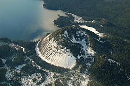
A special landform called Kostal Volcano rises from the lake's northeast shore. It stands about 150 m (492 ft) tall. Even though it's called a volcano, it's not active anymore. It's a cool example of the area's volcanic past.
 | John T. Biggers |
 | Thomas Blackshear |
 | Mark Bradford |
 | Beverly Buchanan |


