Quesnel Highland facts for kids
Quick facts for kids Quesnel Highland |
|
|---|---|

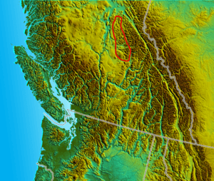
Approximate boundary of the Quensel Highland
|
|
| Location | British Columbia, Canada |
| Coordinates | 52°30′00″N 121°00′00″W / 52.50000°N 121.00000°W |
| Part of | Cariboo Mountains and Cariboo Plateau |
The Quesnel Highland is a special area in the middle of British Columbia, a province in Canada. It's like a hilly, raised area that sits between two other important landforms: the Cariboo Plateau and the Cariboo Mountains. Think of it as a natural "buffer zone" or a set of foothills.
This area stretches from a spot southeast of the city of Prince George. It goes all the way to the Mahood Lake area, which is in the southeastern part of the Cariboo region.
Contents
What is the Quesnel Highland?
The Quesnel Highland is a mix of hills and flat, high areas. It acts as a natural border between the lower Interior Plateau and the taller Cariboo Mountains. A geographer named Holland described it in a book called Landforms of British Columbia. This book is often used as an official guide for British Columbia's geography.
Neighboring Highlands
The Quesnel Highland isn't the only area like this. Right next to Mahood Lake, you'll find the Shuswap Highland. This area has similar terrain and sits between the Thompson Plateau and the Monashee Mountains.
Even further south, near Vernon and Enderby, is the Okanagan Highland. It also acts as a buffer, connecting to the Monashee Mountains and even reaching into Washington State in the USA.
Where are its borders?
The exact edges of the Quesnel Highland are not always super clear. Some people might consider it part of the larger Interior Plateau. Others might see it as a smaller part of the Cariboo Mountains.
The Cariboo Mountains themselves can be a bit confusing! Sometimes they are grouped with the Interior Plateau. Other times, they are seen as the most northern part of the Columbia Mountains.
What areas does it include?
Generally, the Quesnel Highland includes the lower, western valleys of several lakes. These include Horsefly Lake, Quesnel Lake, and the Bowron Lakes.
It also covers most of the towns that were important during the Cariboo Gold Rush. The area continues northwest from there. It reaches to about where the Willow River curves around the northern end of the Cariboo Mountains to join the big Fraser River.
 | Jessica Watkins |
 | Robert Henry Lawrence Jr. |
 | Mae Jemison |
 | Sian Proctor |
 | Guion Bluford |

