
Moul Falls facts for kids
Quick facts for kids Moul Falls |
|
|---|---|
 |
|
| Lua error in Module:Infobox_mapframe at line 185: attempt to index field 'wikibase' (a nil value). | |
| Location | Wells Gray Provincial Park, British Columbia, Canada |
| Coordinates | 51°50′05″N 120°02′59″W / 51.83472°N 120.04972°W |
| Type | Plunge |
| Total height | 35 m (115 ft) |
| Total width | 9 m (30 ft) |
| Watercourse | Grouse Creek |
Moul Falls is a beautiful waterfall located in Wells Gray Provincial Park in British Columbia, Canada. It's a very popular spot for hikers. What makes Moul Falls special is that it's the only waterfall in the park where you can actually walk behind the falling water! It is also the third tallest waterfall in the park.
The water for Moul Falls comes from Grouse Creek. This creek starts high up from melting snow, a lake, and natural springs between Trophy Mountain and Table Mountain. Grouse Creek flows for about 18 kilometers (11 miles) before it plunges over Moul Falls. After that, it continues to McDiarmid Falls and then joins the Clearwater River.
Why is it Called Moul Falls?
Moul Falls is named after George William Moul. He was one of the first people to settle in this area way back in 1915. He lived on land just east of the falls. George Moul left the area in 1918 to serve in World War I. After the war, he moved to Vancouver and worked for the Canadian Pacific Railway. He passed away in 1947.
The creek that forms Moul Falls, Grouse Creek, has had many names over time. It's actually had more name changes than any other place in Wells Gray Park! In the early 1900s, maps called it Beaver Creek. Later, people started calling it Grouse Creek because there were so many blue grouse birds in the forests nearby.
For a while, both the waterfall and the creek were known as Moul. But by the 1980s, locals started using the name Grouse Creek again for the stream. To clear up the confusion, the Friends of Wells Gray Park asked the Geographical Names Office to decide. After looking into how people used the names, they officially decided on Grouse Creek for the stream. However, the waterfall kept its name, Moul Falls.
Visiting Moul Falls
The trail to Moul Falls starts from a parking lot on Clearwater Valley Road, which is also known as Wells Gray Park Road. The hike to the falls takes about one hour each way. It's a fun and fairly easy walk.
When you get to the falls, you'll see that Grouse Creek flows through a narrow canyon just before it drops. This makes it hard to see the falls from directly above. To get a great view, you can use the stairs that lead down to the bottom of Moul Falls. These stairs were built in 1997 by local families and groups who care about the park. Now, B.C. Parks helps maintain them.
From July until winter, you can actually walk behind the waterfall! There's a large cave that has been carved out by the water's spray over many years. On a hot summer day, the pool at the bottom of the falls is a wonderful place for a swim.
There's also a footbridge that crosses Grouse Creek just above the falls. From here, you can find other trails. Some lead to McDiarmid Falls, which is downstream from Moul Falls. Other trails follow the cliffs above the Clearwater River, offering more great views.
Winter Visits
In very cold and snowy winters, Moul Falls can create a giant ice cone! This ice cone can grow so large that it reaches halfway up the falls. If you want to visit in winter, snowshoes are the best way to get there. Cross-country skiers can also reach the falls, but the trail has some steep downhill parts that require expert skills.
Images for kids
-
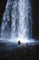
The plunge pool at Moul Falls, great for a swim!
-
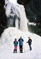
Moul Falls can form a huge ice cone in winter.

