
Ray Lake facts for kids
Quick facts for kids Ray Lake |
|
|---|---|

Ray Lake
Location in British Columbia
|
|
| Location | British Columbia |
| Coordinates | 52°14′N 120°04′W / 52.233°N 120.067°W |
| Primary inflows | Falls Creek |
| Primary outflows | Falls Creek |
| Basin countries | Canada |
| Max. length | 3.5 km (2.2 mi) |
| Surface elevation | 1,350 m (4,429 ft) |
Ray Lake is a beautiful lake found in Wells Gray Provincial Park in British Columbia, Canada. It gets its water from Falls Creek, which also flows out of the lake. Falls Creek then joins the Clearwater River after it leaves Clearwater Lake.
Contents
Why Is It Called Ray Lake?
Ray Lake and nearby Mount Ray are named after a pioneer named John Ray. He settled near the Clearwater River in 1911. John built a small cabin near what is now called Alice Lake. Later, in 1929, he built a bigger cabin that is still there today.
In 1932, John Ray, at 54 years old, married Alice Ludtke. She was 20. They raised three children, Nancy, Doug, and Robert, on their remote farm. The Ray family left their farm in 1946 so their children could go to school. John continued to move his family's belongings out of the valley. His last trip to the farm was in December 1947, where he passed away. Alice passed away in 1959. Their graves are located near their old home.
How to Visit Ray Lake
It is very hard to visit Ray Lake because there are no easy ways to get there. The closest path is the Kostal Lake Trail, which is over 5 km (3.1 mi) to the south and is very overgrown. Falls Creek is too difficult for boats to travel on. Also, float planes and helicopters are not allowed to land at Ray Lake.
Understanding the Geology of Ray Lake
Mount Ray's Volcanic Past
Mount Ray, which is west of Ray Lake, erupted about 20,000 years ago. At that time, thick glacial ice covered the mountain. The eruption was so powerful that it melted through the ice. This type of volcano, which forms under ice, is called a tuya. After the eruption, the ice covered the mountain again. Mount Ray has a distinct red top and you can see it from Clearwater Lake.
The Dragon's Tongue Lava Flow
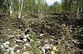
Dragon Cone, located just east of Ray Lake, erupted about 7,500 years ago. The lava from this eruption, known as the Dragon's Tongue, flowed for 15 km (9.3 mi) down the Falls Creek Valley. This lava flow created a natural dam, which made Ray Lake bigger than it was before. The end of this lava flow also blocked the Clearwater River, raising the water level of Clearwater Lake by about 5 m (16 ft). You can hike a trail from Clearwater Lake Campground to see the Dragon's Tongue, which looks like piles of sharp, jagged lava.
Images for kids
-
Dragon's Tongue southwest of Ray Lake

