Mount Ray (British Columbia) facts for kids
Quick facts for kids Mount Ray |
|
|---|---|

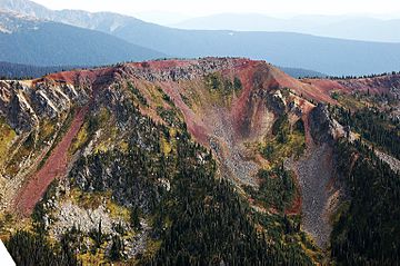
Aerial view of Mount Ray
|
|
| Highest point | |
| Elevation | 2,046 m (6,713 ft) |
| Geography | |
| Location | British Columbia, Canada |
| Parent range | Cariboo Mountains |
| Geology | |
| Age of rock | Pleistocene |
| Mountain type | Subglacial mound |
| Volcanic arc/belt | Wells Gray-Clearwater volcanic field |
| Last eruption | 20,000 years |
Mount Ray, also called Ray Mountain, is a special kind of volcano in Wells Gray Provincial Park in British Columbia, Canada. It's known as a subglacial mound, which means it formed under a thick layer of ice! This mountain last erupted a very long time ago, about 20,000 years ago, during the Pleistocene Ice Age. It's part of a group of volcanoes called the Wells Gray-Clearwater volcanic field.
A Volcano Under Ice
Imagine a volcano erupting when it's covered by a huge glacier! That's what happened with Mount Ray. The thick ice in the valleys around the mountain acted like walls. Because of these icy walls, the hot lava could not spread very far from where it erupted. This is why Mount Ray has its unique shape.
Who Was John Bunyan Ray?
Mount Ray was named after a man named John Bunyan Ray. He was the very first settler to live in the Clearwater Valley. John Ray was born in 1878 in North Carolina. He moved to the Valley in 1909.
John worked hard to clear land and start a farm in the wild area south of Clearwater Lake. In 1932, he married Alice Ludtke. They had three children together: Nancy, Doug, and Bob.
Moving for School
In 1946, the Ray family decided to move. They went to the North Thompson Valley. They moved mainly so their children could go to a regular school. Before that, the children learned their lessons through mail, which is called correspondence.
In December 1947, John Ray went back to his old farm. He passed away there from a heart attack. Other places in the area are also named after John Ray. These include Ray Lake, which is east of Mount Ray, and Ray Mineral Spring.
Seeing Mount Ray
Mount Ray is a beautiful sight. It is best seen from an airplane. From above, its bright red color stands out against the green forest below. You can also see the western slopes of the mountain from boats on Clearwater Lake.
There are no hiking trails that go close to Mount Ray. A trail called the Kostal Lake trail used to pass about 8 kilometres (5 miles) to the south. However, BC Parks permanently closed this trail in 2013.
 | Selma Burke |
 | Pauline Powell Burns |
 | Frederick J. Brown |
 | Robert Blackburn |

