Flourmill Volcanoes facts for kids
Quick facts for kids Flourmill Volcanoes |
|
|---|---|
| The Flourmills | |

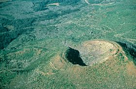
Flourmill Centre as seen from the northeast.
|
|
| Highest point | |
| Peak | Spanish Lake Centre |
| Elevation | 1,770 m (5,810 ft) |
| Geography | |
| Country | Canada |
| Province | British Columbia |
| Parent range | Quesnel Highland |
| Geology | |
| Age of rock | Holocene |
The Flourmill Volcanoes, also known as The Flourmills, are a small group of volcanoes. You can find them near the western edge of Wells Gray Provincial Park in east-central British Columbia, Canada. They are located north of Mahood Lake and west of the Clearwater River. These volcanoes are part of a larger area called the Wells Gray-Clearwater volcanic field.
Contents
Exploring the Flourmill Volcanoes
This volcanic area has two main parts: the Flourmill Centre and the Spanish Lake Centre. About 3,000 years ago, these volcanoes were active. Hot lava burst out from the sides of their craters. This lava then flowed into the valley between Spanish Creek and Flourmill Creek. The flowing lava even blocked Spanish Creek, which created a new body of water called Spanish Lake. This lake now covers about 10 kilometers (6 miles) of the Spanish valley. The lava flows are usually about 10 meters (33 feet) thick. Both volcanoes formed on top of old glacial material.
Spanish Lake Volcano Centre
The Spanish Lake Centre is the northern part of the Flourmill Volcanoes. It sits about 2.5 kilometers (1.6 miles) east of Spanish Lake. This volcano reaches a height of 1,770 meters (5,807 feet). It is made up of an older, larger cone and two smaller, younger cones. These smaller cones are called parasitic cones because they grew on the side of the main volcano.
Lava flows from this center moved west into the Spanish Creek valley. One flow came from the northern edge of the Spanish Lake Centre. It was about 7 to 10 meters (23 to 33 feet) thick. Another, larger lava flow came from the southwest side of the inner cone. This powerful flow destroyed a big part of the outer cone.
Flourmill Volcano Centre
The Flourmill Centre is the southern part of the Flourmill Volcanoes. It is located where Flourmill Creek begins. This center is 1,495 meters (4,905 feet) high and rises about 250 meters (820 feet) from its base. It is made of three cinder cones that overlap. They formed at slightly different times. The oldest cone is on the northeast side. It is only partly left because later eruptions covered or destroyed some of it.
New volcanic activity on the southwest side created another cone. This cone was made of loose volcanic rocks. Several well-preserved round and "breadcrust" shaped volcanic bombs were found here. A break on the south side of this cone allowed lava to drain from a lava lake inside its crater.
The newest part of the Flourmill Centre is a well-preserved cone on the northwest side. It sits partly on top of the older deposits. Its crater has a break on the southwest side and still holds parts of a lava lake.
Just like the Spanish Lake Centre, lava from the Flourmill Centre also flowed into the Spanish Creek valley. Scientists have found three different lava flows here. Each flow is about 7 to 10 meters (23 to 33 feet) thick along Spanish Creek. These lava beds stretch about 15 kilometers (9.3 miles) down the valley. They are up to 2 kilometers (1.2 miles) wide.
Human History of the Flourmills
The unique name 'Flourmill' comes from a land survey done in 1921. This survey was along the Clearwater River. They found that Flourmill Creek entered the Clearwater River exactly four miles (6.5 km) north of where the Mahood River joins it. So, it was first called Four Mile Creek. However, there were already many other "Four Mile Creeks" in British Columbia. To avoid confusion, map-makers changed the letters to create 'Flourmill' Creek instead. The volcanoes got their name from this creek. They were first mentioned as 'Flourmill Volcanoes' in a book called Exploring Wells Gray Park in 1974.
The first recorded visit by non-native people to the Flourmill Volcanoes happened on May 21, 1874. It was by a surveyor named Joseph Hunter and his three helpers. Hunter worked for the Canadian Pacific Survey. His diary describes their trip over the Flourmill lava flow. He wrote about the valley being covered with volcanic rocks. He noted that the center of the valley was higher than the sides.
The Flourmill Volcanoes were part of a big land deal in 1963. A company called Clearwater Timber Products wanted to cut down trees in Wells Gray Park. They tried several times but were not allowed. So, the company bought a beach property on Vancouver Island for $186,000. They then offered this land to the government. In return, they asked for permission to log trees in Wells Gray Park. The government agreed to this deal. They created Rathtrevor Beach Provincial Park from the beach property. Today, this is one of British Columbia's most popular parks. In exchange, Clearwater Timber was allowed to log trees on 137 square kilometers (53 square miles) around The Flourmills. The company built a road to reach this forest. Over the next six years, they removed a lot of timber.
In 1972, a new government was elected. They stopped the logging deal. Later, the bridge at the Mahood River was removed. This made it harder to reach The Flourmills from the east. In 1986, the volcanoes and the areas around them were added to Wells Gray Park.
How to Visit the Flourmill Volcanoes
You can reach the Flourmill Volcanoes by taking a rough road from 100 Mile House. This road is off Highway 97. It has many turns that are not marked, so it's important to have good directions. Books like Exploring Wells Gray Park can help. The road ends at Spanish Creek. From there, a trail leads about 3.2 kilometers (2 miles) to the base of the south cone. You can walk another 0.5 kilometers (0.3 miles) to see a part of the lava flow.
 | Leon Lynch |
 | Milton P. Webster |
 | Ferdinand Smith |


