Flatiron (volcano) facts for kids
Quick facts for kids Flatiron |
|
|---|---|

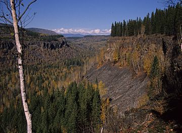
Lava cliffs in Hemp Canyonlands near the Flatiron
|
|
| Highest point | |
| Elevation | 730 m (2,395 ft) |
| Prominence | 90 m (295 ft) |
| Geography | |
| Location | British Columbia, Canada |
| Geology | |
| Age of rock | Pleistocene |
| Mountain type | Volcanic outcrop |
| Volcanic arc/belt | Wells Gray-Clearwater volcanic field |
| Last eruption | 200,000 years |
| Climbing | |
| Easiest route | Trail and bushwhack from Clearwater Valley Road |
The Flatiron is a special rock formation in Wells Gray Provincial Park in British Columbia, Canada. It looks a bit like a giant, old-fashioned clothes iron! This amazing natural landmark was once part of a volcano. Over many years, wind, water, and ice have worn it down to its current shape.
The Flatiron stands about 90 meters (295 feet) tall. It stretches for about 500 meters (1,640 feet) in length. Its width is usually around 125 meters (410 feet). Two creeks, Hemp Creek and Trout Creek, flow on either side of this unique rock.
How The Flatiron Was Formed
About 200,000 years ago, a large lake filled the area now known as the Hemp Canyonlands. This ancient lake was much higher than the valley floor you see today. We don't know exactly how this lake formed. It might have been blocked by ice, a landslide, or even an old lava flow.
During this time, a volcano erupted right into the lake! This is called a "ponded lava flow." The hot lava cooled quickly as it hit the water. It formed a huge, flat sheet that once stretched across the entire Hemp Creek Valley.
Later, as glaciers melted, massive floods rushed through the valley. These powerful floods carried away much of the lava. What was left behind is The Flatiron, standing tall as a reminder of its fiery past. The water flow during these floods was incredibly strong. It might have been 100 times bigger than Hemp Creek is today!
The lava that makes up The Flatiron cooled very slowly. This slow cooling created amazing columns of rock. These columns are a great example of something called columnar basalt. Over time, these columns have slowly broken off and fallen to the base. This means The Flatiron is slowly getting thinner!
Visiting The Flatiron
You can hike to see The Flatiron! A one-hour walk from Clearwater Valley Road will take you to a viewpoint. From there, you can see the Hemp Canyonlands and The Flatiron in the distance.
If you want to get closer, you can hike for another 30 minutes. After that, you'll need to leave the main path. You'll have to make your own way through the bushes to reach the base of The Flatiron.
The cliffs almost completely surround The Flatiron. Because of this, the only way to reach the very top is by climbing up the west side, above Hemp Creek.
 | Charles R. Drew |
 | Benjamin Banneker |
 | Jane C. Wright |
 | Roger Arliner Young |

