Della Falls facts for kids
Quick facts for kids Della Falls |
|
|---|---|

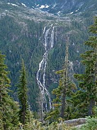
Della Falls as viewed from Love Lake Trail
|
|
| Lua error in Module:Infobox_mapframe at line 185: attempt to index field 'wikibase' (a nil value). | |
| Location | Strathcona Provincial Park, British Columbia |
| Coordinates | 49°27′16″N 125°32′11″W / 49.4544°N 125.5363°W |
| Type | Segmented horsetails |
| Total height | 440 m (1,440 ft) |
| Number of drops | 3 |
| Total width | 107 m (351 ft) |
| Average width | 30 m (98 ft) |
| Run | 411 m (1,348 ft) |
| Watercourse | Della Creek |
| Average flow rate |
1.5 m3/s (53 cu ft/s) |
| World height ranking | 172nd |
Della Falls is a super tall waterfall found in Strathcona Provincial Park. This park is located on Vancouver Island in British Columbia, Canada. Della Falls drops an amazing 440 m (1,440 ft)!
This makes it one of the tallest waterfalls in Canada. In fact, it is the 16th tallest confirmed waterfall in the whole country. It is also the second tallest waterfall on Vancouver Island. Only Kiwi Falls is taller.
Who Found Della Falls?
A man named Joe Drinkwater discovered Della Falls in 1899. Joe was a prospector, meaning he searched for valuable minerals like gold. He was also a trapper, someone who catches animals for their fur.
Joe named the falls after his wife, Della. He also built a long hiking trail to reach the falls. This trail was about 16 km (10 mi) long. You can still see signs of his old gold mining work near the falls. He even built a special aerial tramway to move things around.
How to Visit Della Falls
Getting to Della Falls is an exciting adventure! The only way to reach it, besides flying in a helicopter, is by boat. You must cross the entire Great Central Lake. The road to the lake only goes to the opposite side from Strathcona Park.
After a 35 km (21 mi) boat trip, you will find a dock. This dock marks the start of Strathcona Park. There is also a camping area here. Many hikers use this spot as a base camp before starting the next part of their journey.
The next part is a 15 km (9 mi) hike to the base of Della Falls. You can find more campsites along the trail. Some are even close to the falls. The hike follows an old logging railway for part of the way. It takes about seven hours to get there one way. This hike is best for people who have some hiking experience.
See also
 In Spanish: Catarata Della para niños
 | Aaron Henry |
 | T. R. M. Howard |
 | Jesse Jackson |

