Garnet Peak facts for kids
Quick facts for kids Garnet Peak |
|
|---|---|

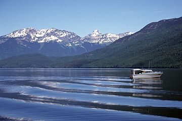
Garnet Peak (center) from Clearwater Lake
|
|
| Highest point | |
| Elevation | 2,876 m (9,436 ft) |
| Prominence | 476 m (1,562 ft) |
| Geography | |
| Parent range | Cariboo Mountains |
| Topo map | 93A/8 or PS-WG3 (north half) |
| Geology | |
| Mountain type | Pyramidal peak |
| Climbing | |
| First ascent | August 29, 1974 by Hugh Neave (leader), Barb Hargreaves, Tor Schmid |
| Easiest route | Southwest ridge via Huntley Col and Tryfan Mtn |
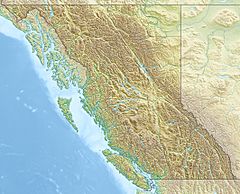
Garnet Peak is a tall mountain in British Columbia, Canada. It's found in the central-eastern part of the province. This peak sits between Goat Creek and Azure Lake.
Garnet Peak is part of the Cariboo Mountains, which are a range within the larger Columbia Mountains. It's the third highest mountain in Wells Gray Provincial Park. Its top reaches 2,876 m (9,436 ft) into the sky!
You can spot Garnet Peak from far away. As you drive the Clearwater Valley Road into Wells Gray Park, it stands out. You can first see it from about 80 km (50 mi) south, at the Clearwater Valley Overlook.
Garnet Peak looks like a pyramid standing by itself. If you look at it from Clearwater Lake, it seems to be part of the Huntley-Buchanan Ridge. This ridge runs along the north side of Azure Lake. But Garnet Peak is actually about 3 km (1.9 mi) north of Tryfan Mountain. A wide, flat ridge connects them at an elevation of 2,400 m (7,874 ft).
If you travel north on Clearwater Lake by boat, you'll notice something interesting. Garnet Peak starts to look smaller and eventually disappears behind the Huntley-Buchanan Ridge. You can't see Garnet Peak from anywhere on Azure Lake.
Contents
First Climb: Reaching the Summit
Garnet Peak was first climbed on August 29, 1974. The climbing team included Hugh Neave, Barb Hargreaves, and Tor Schmid. Hugh Neave was the leader of this group.
Hugh Neave's Dream Climb
Hugh Neave was a bit later to explore Wells Gray Park than others. But he loved the beautiful scenery and the challenge of climbing mountains. He wasn't looking for gold or other riches. In 1966, he made his first trip to the Huntley-Buchanan Ridge. For the next 20 years, he visited these peaks often.
Climbing Garnet Peak was Hugh Neave's big dream. He first saw the mountain in 1966. He tried three times to reach the top, but bad weather stopped him each time. He created the first trail from Azure Lake to Huntley Col. He made the trail better with every trip. Today, this is the only trail from the lake, and people who use it help keep it clear.
Finally, in 1974, when he was 65 years old, Hugh Neave achieved his dream. He reached the summit of Garnet Peak! He named the mountain Garnet Peak because he found small garnet stones in the rocks near the top.
Hugh Neave passed away in 1988. The next year, a mountain just north of Garnet Peak was named Mount Hugh Neave in his honor. This was to remember his many climbs in northern Wells Gray Park. Later in 1988, members of the Kamloops Mountaineering Club carried his ashes to the very top of Garnet Peak.
Climbing Garnet Peak: The Route
Not many people have climbed Garnet Peak since 1974. Fewer than 100 climbers have reached its summit. It's not a super difficult mountain to climb. There's only one short part where you need a rope and special climbing tools called pitons.
The biggest challenges are getting to the mountain and the weather. The weather in northern Wells Gray Park can change very quickly. Most climbing trips are turned back by bad weather. A climb to Garnet Peak should ideally be planned for four days. However, it is possible to do it in three days.
Starting the Journey: Huntley Col Trail
The trail to Huntley Col begins at Four and a Half Mile Campground. This campground is on the north shore of Azure Lake. The trail goes straight up the mountain. It doesn't have easy switchbacks, which are zigzag paths that make climbing easier. It's a steady, tough climb of 1,370 m (4,495 ft) to reach the Col. This climb takes at least five hours, especially when carrying backpacks.
Huntley Col is a good place to set up camp. It's located between Mount Huntley to the west and Batoche Peak to the east. There's a snow patch there all year round, which provides water. It's also protected from the strong, almost constant wind.
The Climb to the Summit
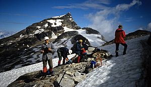
On the second day, the route goes along the north side of Batoche and Tryfan mountains. Then, it crosses the wide, flat ridge (hogsback) north towards Garnet Peak. The actual climb up Garnet Peak is mostly along its southwest ridge. There's one rock section that is about 25 m (82 ft) high. Here, you will need a rope and pitons to climb up. When coming down, you'll need to rappel (slide down a rope). The round trip from Huntley Col to the summit and back takes about 12 hours.
The third day is for climbing back down to Azure Lake. The optional fourth day is a good idea in case of bad weather. Or, you can use it for a hike along the Huntley-Buchanan Ridge, going as far as Tryfan Mountain. For more details on the climbing route, you can check Exploring Wells Gray Park, pages 227-229.
 | Anna J. Cooper |
 | Mary McLeod Bethune |
 | Lillie Mae Bradford |


