
Azure Lake facts for kids
Quick facts for kids Azure Lake |
|
|---|---|

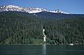
Azure Lake at Garnet Falls with Tryfan Mtn behind
|
|

Azure Lake
Location in British Columbia
|
|
| Location | British Columbia |
| Coordinates | 52°23′00″N 120°07′00″W / 52.38333°N 120.11667°W |
| Primary inflows | Azure River and Angus Horne Creek |
| Primary outflows | Azure River |
| Max. length | 24 km (15 mi) |
| Max. width | 1.2 km (0.7 mi) |
| Surface elevation | 682 m (2,238 ft) |
| Islands | None |
| Settlements | None |
Azure Lake is a beautiful lake in British Columbia, Canada. It looks a bit like a fjord, which is a long, narrow body of water with steep sides, often created by glaciers. The lake is part of the Azure River. This river starts from a glacier in the Cariboo Mountains. The water flows out of Azure Lake and back into the Azure River, but only for about 50 meters (164 feet) before it joins the Clearwater River. Azure Lake is one of six big lakes found in Wells Gray Provincial Park.
Contents
Exploring Azure Lake's Geography
Azure Lake is surrounded by tall mountains. These peaks rise about 1,800 meters (5,900 feet) above the lake's edge. To the north, you can see Mount Huntley, Batoche Peak, Tryfan Mountain, and Buchanan Peak. Garnet Peak, which is the third highest mountain in Wells Gray Park, is north of Tryfan. However, you cannot see it from the lake itself.
South of Azure Lake are Zodiac Mountain and Azure Mountain. Mount Hogue is located at the lake's upper end, to the east. The deep valley where Azure Lake sits was carved out by huge glaciers long ago during the Ice Ages. This created the rugged and steep shorelines you see today.
You can also spot "hanging valleys" along both sides of the lake. These are valleys that are higher than the main valley. Many streams flow into the lake, creating waterfalls. Some of the most famous ones are Garnet Falls, Crystal Falls, Roostertail Falls, and Rainbow Falls.
Discovering the Names of Azure Lake and Mountains
Have you ever wondered how places get their names? Here's how some features around Azure Lake got theirs:
Why is it Called Azure Lake?
The name Azure Lake comes from its beautiful blue color. The name first appeared on a map in 1914. It was also listed in the BC Gazetteer in 1930. Sometimes, people called it Blue Lake. A man named Angus Horne might have named the lake. He moved to Blue River in 1912. He was a prospector, trapper, and explorer in these mountains.
Angus Horne Lake and Creek
Angus Horne Lake and Angus Horne Creek, which flows into Azure Lake, are both named after Angus Horne.
Mount Huntley's Name
Mount Huntley was named by Chess Lyons in 1940. Chess Lyons was sent by Arthur Wellesley Gray, who was in charge of lands in British Columbia. This happened six months after Wells Gray Park was created. Chess Lyons' job was to explore the park and report on its important features. His assistant on this trip was Huntley Campbell, and the mountain was named after him.
Buchanan Peak's Story
Buchanan Peak was also named by Chess Lyons. Robert "Buck" and Sarah Buchanan were from Texas. They lived at Deception Point on Mahood Lake from 1933 to 1941. They owned two boats, Albedrio and Manana. These boats helped the Lyons expedition travel along Mahood and Canim Lakes.
Garnet Peak's Gemstone Name
Garnet Peak was named by Hugh Neave. He led the first group to climb this mountain in 1974. He found many garnets, which are red gemstones, in different spots on the peak.
Tryfan Mountain's Welsh Connection
Tryfan Mountain was named by Hugh Neave. He named it after a famous mountain in Wales. This was where he learned how to rock climb when he was a boy.
Mount Hogue's Trapper Tribute
Mount Hogue was named by Chess Lyons. It honors Henry and John Hogue, who were trappers. They built Helmcken Falls Lodge in 1948. This was the very first place for visitors to stay in Wells Gray Park.
Getting to Azure Lake and Exploring Trails
There are no roads that go directly to Azure Lake. The only way to get there is by boat. You start from the end of the Clearwater Valley Road. This road is at the south end of Clearwater Lake.
Boating to Azure Lake
Motorboats can easily travel up Clearwater Lake. Then, they go through the short Clearwater River and Azure River for about 2.9 kilometers (1.8 miles) to reach Azure Lake. If you enjoy canoeing or kayaking, you can paddle up Clearwater Lake. After that, you can use a special portage trail to carry your boat over to Azure Lake. A portage trail is a path where you carry your canoe or kayak between two bodies of water.
You can also take a water taxi to Azure Lake. Clearwater Lake Tours operates this service. A popular trip is to take the water taxi, loaded with canoes or kayaks, to Rainbow Falls. Then, you can paddle back to the south end of Clearwater Lake.
Flying to Azure Lake
Flying to Azure Lake is usually not allowed. You need a special permit from B.C. Parks if you want to land a float plane or helicopter there.
Campsites on Azure Lake
There are four campsites along Azure Lake. Osprey and Rainbow Falls campsites are on the south shore. Indian Point and Four and a Half Mile campsites are on the north shore. You pay fees at the boat launching ramp on Clearwater Lake. You cannot reserve these campsites ahead of time.

Hiking Trails Around Azure Lake
There is only one main hiking trail from the shore of Azure Lake. This trail leads to Huntley Col. A mountain climber and explorer named Hugh Neave first marked this trail in 1966. Other hikers have improved it since then. It is a very tough climb, taking about five hours to go up 1,370 meters (4,495 feet).
From Huntley Col, experienced climbers can try to climb the peaks along the Huntley-Buchanan Ridge. This often takes several days. Hikers can set up a base camp at Huntley Col, where water is available. Climbing Garnet Peak usually takes four days from the Huntley Col trail. It also requires special rock climbing skills. Besides this one trail, hiking from Azure Lake is very hard because the plants and trees are extremely thick.
Images for kids
-
Azure Lake at Garnet Falls with Tryfan Mtn behind
