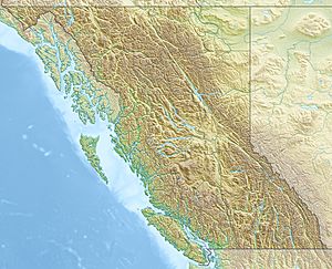
McGregor Plateau facts for kids
Quick facts for kids McGregor Plateau |
|
|---|---|
| Location | British Columbia, Canada |
| Coordinates | 54°20′N 121°00′W / 54.333°N 121.000°W |
| Part of | Nechako Plateau |
The McGregor Plateau is a special kind of flat, high land area in British Columbia, Canada. It is part of a bigger region called the Nechako Plateau. This whole area is a large part of the Interior Plateau, which covers much of the inland Pacific Northwest.
The McGregor Plateau is found east of the city of Prince George, British Columbia. It sits between the Northern Rocky Mountains to the east and the Fraser River to the west. This plateau stretches from where the Torpy River meets the Fraser River, going northwest. It runs alongside both the Fraser River and the Rocky Mountains.
What Makes the McGregor Plateau Special?
This plateau is quite mountainous, even though it's called a plateau. It has many hills and valleys. Several important rivers flow through it. The biggest rivers are the McGregor River and Herrick Creek. Inside the McGregor Plateau, there is also a mountain range called the McGregor Range. This range is located between the McGregor and Torpy Rivers.
How the McGregor Plateau Got Its Name
The McGregor Plateau is named after a brave soldier, Captain James Herrick McGregor. He was a land surveyor (PLS) before he joined the army. Captain McGregor sadly died during World War I on April 25, 1915. He was serving with the 16th Battalion Canadian Highland Brigade at a battle called the Second Battle of Ypres. Naming the plateau after him helps remember his service and sacrifice.
 | Delilah Pierce |
 | Gordon Parks |
 | Augusta Savage |
 | Charles Ethan Porter |


