The Volcano (British Columbia) facts for kids
Quick facts for kids The Volcano |
|
|---|---|

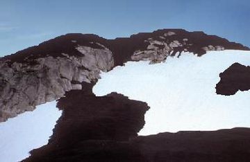
The Volcano with thick black scoria in the foreground
|
|
| Highest point | |
| Elevation | 1,656 m (5,433 ft) |
| Prominence | 311 m (1,020 ft) |
| Listing | List of volcanoes in Canada |
| Geography | |
| Location | British Columbia, Canada |
| Parent range | Boundary Ranges (Coast Mountains) |
| Topo map | NTS 104B/07 |
| Geology | |
| Mountain type | Cinder cone |
| Volcanic arc/belt | Northern Cordilleran Volcanic Province |
| Last eruption | 1800 (?) |
The Volcano, also known as Lava Fork volcano, is a small cinder cone in the Boundary Ranges of the Coast Mountains in northwestern British Columbia, Canada. It is about 60 kilometers (37 miles) northwest of the town of Stewart.
The Volcano is 1,656 meters (5,433 feet) tall. It stands out from the mountains around it. It is part of a group of volcanoes called the Iskut-Unuk River Cones. These are part of a much larger chain of volcanoes called the Northern Cordilleran Volcanic Province. This chain stretches from Alaska to Prince Rupert, British Columbia.
The Volcano is quite young compared to most other volcanoes in this area. Scientists believe it formed and erupted within the last 400 years. This was long after the last ice age, which ended about 10,000 years ago.
Contents
How The Volcano Formed
The Volcano is the most southern of 10 volcanoes in the Iskut-Unuk River Cones area. It is also the most recent one to have erupted. Its shape has been changed by erosion from ice and weather.
Like most cinder cones, The Volcano is made of loose volcanic materials. These include volcanic ash, small rock pieces called lapilli, and larger rocks called volcanic bombs. These materials were thrown out when lava fountains erupted. The area where the lava came out has volcanic bombs up to 0.5 meters (1.6 feet) long. It also has small amounts of sulfur from volcanic gases.
The Volcano formed because the Earth's crust is slowly pulling apart in this area. This is called continental rifting. It happens because the Pacific Plate is sliding north along the Queen Charlotte Fault. As the crust stretches, it cracks. Hot, melted rock called Basaltic magma rises through these cracks. This causes effusive eruptions, where lava flows out. This rift zone has been active for at least 14.9 million years. It created the Northern Cordilleran Volcanic Province. The Volcano is one of three volcanoes in this area that have erupted in the last few hundred years.
When Did The Volcano Erupt?

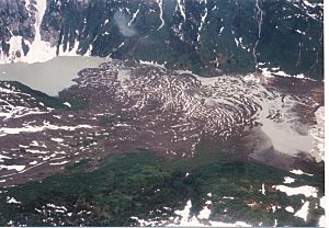
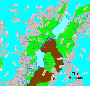
Scientists have found signs of at least two times when The Volcano was active. Each time, long flows of basaltic lava poured down the mountain. The lava then traveled through the Lava Fork valley for about 5 kilometers (3 miles). It even crossed the border into Alaska. There, the lava blocked the Blue River, creating several lakes.
These lava flows are about 22 kilometers (14 miles) long. They still look much like they did when they cooled. You can see features like pressure ridges and lava channels. During the eruptions, large trees were covered by the lava. The bottom parts of the trees burned, and the tops fell into the cooling lava. This left tree-shaped holes on the surface. Some of these holes and lava tubes later collapsed, forming pits.
A surveyor named Fremont Morse first noticed one of the lava flows in 1905. He thought it had erupted less than 50 years before. Later, scientists used tree ring and radiocarbon dating to find the exact dates. They believe the first eruption happened about 360 years ago. The most recent one might have been only 150 years ago. This makes The Volcano the youngest known volcanic mountain in Canada.
Even though The Volcano last erupted about 150 years ago, it is still active. It is one of five volcanoes in the Northern Cordilleran Volcanic Province that have had small earthquakes since 1985. These earthquakes suggest that there is still active magma chambers (pools of melted rock) underground. This means these volcanoes could erupt again.
Protecting The Volcano Area
Lava Forks Provincial Park
The Volcano, its lava flows, and a large mineral spring are protected in Lava Forks Provincial Park. This park was created in 2001 and covers about 7,000 hectares (17,000 acres). It is a very remote park. Inside the park are the Lava Lakes, which were formed when lava flows blocked a river.
The park is in the traditional land of the Tahltan First Nation. It is a great place to study how plants grow back after a big event like a volcanic eruption. After 150 years, plants like mosses and lichens have started to grow on the lava flows. Larger trees like Western Hemlock and Mountain Hemlock also grow in the area.
Watching for Activity
The Volcano is not watched very closely by the Geological Survey of Canada. This is partly because it is in a remote area. Also, Canada has not had any major volcanic eruptions in the last few hundred years. So, watching volcanoes is not as high a priority as dealing with tsunamis, earthquakes, and landslides.
However, because there are still earthquakes, scientists expect more volcanic activity in the future. This could affect the landscape around the volcano. Because of these concerns, Canadian university scientists are working to learn more about the state of volcanoes in Canada.
Volcano Dangers
The Iskut-Unuk River volcanic field has had at least seven eruptions in the last 10,000 years. Since about 1600, all these eruptions have happened at The Volcano. The total amount of lava and ash erupted is about 2.2 cubic kilometers (0.53 cubic miles). Future eruptions from The Volcano will likely be similar to those in the past 360 years.
There is a small chance (about one in 200 per year) of a volcanic eruption happening in Canada. An eruption is more likely to happen in the Northern Cordilleran Volcanic Province than in other areas. This is because it is the most active volcanic zone in Canada.
What Could Happen?
Future eruptions at The Volcano are expected to have only a small impact. Because it is in a remote area with no people living nearby, the volcanic hazards are not extreme.
Ash and rock pieces thrown out during eruptions are not likely to go high enough to stop big airplanes. However, they could be a danger to lower-flying aircraft along the coast between Vancouver and Alaska. Volcanic ash can make it hard to see and can damage jet engines.
Lava flows from future eruptions would likely be basaltic. This type of lava has low silica content and can flow quickly, from 15 to 50 kilometers per hour (9 to 31 miles per hour).
The last eruption 150 years ago had a big impact on fish, plants, and animals in the valley. The lava flows blocked rivers and changed their paths. Future eruptions could do this again if there is enough lava. This would be bad for fish and their spawning grounds. However, there are no records of people being harmed by this eruption. It is not even known if anyone saw it happen. Also, there is a chance of wildfires in the Lava Fork valley if new lava flows burn the plants growing on and around the old lava.
See also
In Spanish: The Volcano para niños
 | James Van Der Zee |
 | Alma Thomas |
 | Ellis Wilson |
 | Margaret Taylor-Burroughs |


