
Franklin Glacier Complex facts for kids
The Franklin Glacier Complex is an old, worn-down volcano located in the Waddington Range of southwestern British Columbia, Canada. It's about 65 km (40 mi) northeast of Kingcome. This area, which isn't fully explored, is found near Franklin Glacier and Mount Waddington. The complex is very high up, over 2,000 m (6,600 ft) tall, so a large part of it is covered in glacial ice.
Volcanic activity at the Franklin Glacier Complex happened for about four million years, from the Late Miocene to the Early Pleistocene epochs. The last known volcanic eruption here was around 2.2 million years ago. Hot springs nearby suggest that there is still heat deep underground from the volcano. Because of this, people are interested in using its heat for geothermal exploration, which means finding ways to use the Earth's heat for energy.
Quick facts for kids Franklin Glacier Complex |
|
|---|---|

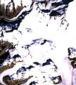
Satellite image of the Franklin Glacier Complex
|
|
| Highest point | |
| Elevation | 2,000+ m (6,600+ ft) |
| Dimensions | |
| Length | 20 km (12 mi) |
| Width | 6 km (3.7 mi) |
| Area | 130 km2 (50 sq mi) |
| Geography | |
| Country | Canada |
| Province | British Columbia |
| District | Range 2 Coast Land District |
| Parent range | Waddington Range |
| Topo map | NTS 92N/6 |
| Geology | |
| Age of rock | Miocene-to-Pleistocene |
| Mountain type | Eroded volcano |
| Volcanic arc/belt | Canadian Cascade Arc Pemberton/Garibaldi Belt |
Contents
Exploring the Area Around the Franklin Glacier Complex
The Franklin Glacier Complex is located in a part of British Columbia called the Range 2 Coast Land District. The land here is very rugged, with mountains rising more than 2,000 m (6,600 ft) from the valleys.
The Franklin Glacier itself is about 18 km (11 mi) long and fills a valley. It starts from a large icefield below the west side of Mount Waddington. This area is part of the Waddington Range, which is a smaller part of the Pacific Ranges, all within the larger Coast Mountains.
How Glaciers Shaped the Land
A massive ice sheet called the Cordilleran Ice Sheet once covered the Franklin Glacier Complex. This huge sheet of ice began to melt back about 13,000 years ago. Since then, the Franklin Glacier has grown and shrunk many times throughout the Holocene period (our current geological epoch).
It seems the glacier got much smaller during a warm period in the early Holocene. Then, it grew bigger again at different times: about 6,300, 5,400, 4,600, 4,100, 3,100, 2,400, 1,500, 800, and 600 years ago. These times when the glacier expanded usually happened when summers were cool, wet, and snowy.
Understanding the Geology of the Franklin Glacier Complex
Not many detailed studies have been done on the Franklin Glacier Complex, so its geology (how its rocks and landforms were created) is not well understood. The complex is about 6 km (3.7 mi) wide and 20 km (12 mi) long, covering an area of about 130 km2 (50 sq mi) in an oval shape.
The rocks here are mostly a type of volcanic rock called dacite breccia, which is made of broken, sharp pieces of volcanic rock. There are also some dacite flows (where molten rock flowed out) and a few bits of hornblende andesite. Because there's no pumice or volcanic glass in the breccia, scientists think it might have formed when a caldera (a large volcanic crater) collapsed and filled in. This is why the complex is sometimes described as a caldera or a "cauldron subsidence."
Underground Rocks and Hot Springs
Because the volcanic rocks have been heavily worn away by erosion, we can see older rocks underneath. These include different types of porphyry and quartz monzonite rocks that formed deep underground. These rocks pushed their way through older, fractured granitic and metamorphic rocks that make up the Coast Plutonic Complex.
The Franklin Glacier Complex is located where the Garibaldi Volcanic Belt and Pemberton Volcanic Belt overlap. These volcanic belts formed because of subduction (where one Earth plate slides under another) along the Cascade Volcanic Arc over the last 29 million years.
Scientists have found two main periods of volcanic activity at the Franklin Glacier Complex. The first period, about 6.8 million years ago, involved a large mass of quartz monzonite rock pushing up in the center. During this time, valuable minerals like copper and molybdenum were deposited. A second period of activity happened between 2.2 and 3.9 million years ago, with smaller rock intrusions that may have fed the volcanoes above. The Franklin Glacier Complex is much older than the nearby Silverthrone Caldera.
Hot Springs and Geothermal Energy
Just west of the Franklin Glacier Complex, there are several hot springs in the valleys. At Canyon Lake, a hot spring feeds a small stream that flows into the lake. The water from this spring has been measured at 58 °C (136 °F). The temperatures of other springs, like those at Hoodoo Creek and Pinter, are not known.
These hot springs show that there's still heat underground, making the Franklin Glacier Complex a potential spot for geothermal energy. However, not much exploration has happened because the area is very remote and hard to reach. The only work done so far has been some basic geologic mapping. There's a proposal to build a 50-megawatt power plant at Canyon Lake, which would use the Earth's heat to generate electricity.
History of Exploration and Naming
People have been exploring the Franklin Glacier Complex for minerals off and on since at least the 1960s. The first recorded work was by Kennco Exploration Limited, who found copper and molybdenum minerals. They did some geological mapping, took soil samples, and drilled seven short holes. Kennco didn't do any more work, and their claims ended in 1976.
Later that year, United Mineral Services Limited took over the claims. In 1987–1988, United Pacific Gold Limited did more detailed work, including digging trenches, mapping, using geophysics (studying the Earth's physical properties), and drilling nine more holes. In 1996, new claims were made by F. Onucki and J. R. Deighton, who were looking for reports of high-grade silver minerals.
The Franklin Glacier was skied by Canadian mountaineers Don Munday and Phyllis Munday on July 22, 1930. They were exploring and mapping glaciers in the Waddington Range. Don Munday named the glacier in 1927 because it was connected to the Franklin River, which was named after a Benjamin Franklin at Tatla Lake.
Images for kids
-
Satellite image of the Franklin Glacier Complex
