Mount Quincy Adams (Fairweather Range) facts for kids
Quick facts for kids Mount Quincy Adams |
|
|---|---|

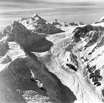
Mount Quincy Adams in upper left, with Mount Tlingit below/left of it. Aerial view by Austin Post. 1972
|
|
| Highest point | |
| Elevation | 4,150 m (13,620 ft) |
| Prominence | 410 m (1,350 ft) |
| Geography | |
| Parent range | Fairweather Range |
| Topo map | USGS Mount Fairweather D-5 |
| Climbing | |
| First ascent | Bradford Washburn, H. Adams Carter, 1934 |
Mount Quincy Adams (also known as Boundary Peak 163) is a very tall mountain that sits right on the border between the United States and Canada. It's named after John Quincy Adams (1767–1848), who was the sixth president of the United States.
Contents
Where is Mount Quincy Adams?
Mount Quincy Adams is located in a beautiful, wild area.
- The southern and eastern sides of the mountain are in Glacier Bay National Park in Alaska, USA. This park is famous for its huge glaciers and amazing wildlife.
- The northern and northwestern sides are in Tatshenshini-Alsek Provincial Park in British Columbia, Canada. This Canadian park is also known for its stunning wilderness.
Because it's partly in British Columbia, Mount Quincy Adams is the second-highest mountain in that Canadian province! It stands next to Mount Fairweather to its west, which is an even taller peak at 4,671 m (15,325 ft).
How Tall is Mount Quincy Adams?
Mount Quincy Adams reaches a height of 4,150 m (13,615 ft). This makes it one of the tallest mountains in the region. Its height is measured from sea level.
Who First Climbed Mount Quincy Adams?
The first people to successfully climb Mount Quincy Adams were Bradford Washburn and H. Adams Carter. They reached the top in 1934. Climbing mountains like this is a huge challenge, requiring a lot of skill and bravery.
What is a Boundary Peak?
Mount Quincy Adams is sometimes called "Boundary Peak 163." This means it's one of the specific points used to mark the exact border between two countries. In this case, it helps define the border between the United States and Canada.
 | James B. Knighten |
 | Azellia White |
 | Willa Brown |


