Mount Fairweather facts for kids
Quick facts for kids Mount Fairweather |
|
|---|---|
| Tsalxhaan | |

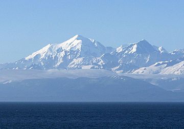
Mount Fairweather (left) with Mount Quincy Adams (right) from the Pacific Ocean, 2001.
|
|
| Highest point | |
| Elevation | 4671 m (15,325 ft) NAVD88 |
| Prominence | 3961 m (12,995 ft) |
| Isolation | 200 km (124.4 mi) |
| Listing |
|
| Geography | |
| Location | Glacier Bay National Park and Preserve, Alaska / Stikine Region, British Columbia |
| Parent range | Fairweather Range |
| Topo map | NTS 114I/13 |
| Climbing | |
| First ascent | June 8, 1931 by Allen Carpé and Terris Moore |
| Easiest route | glacier/snow/ice climb |
Mount Fairweather is a very tall mountain. It is the highest peak in the Canadian province of British Columbia. Its top reaches 4,671 metres (15,325 ft) into the sky.
This mountain is about 20 kilometres (12 mi) east of the Pacific Ocean. It sits right on the border between Alaska in the United States and western British Columbia, Canada. Most of Mount Fairweather is inside Glacier Bay National Park and Preserve in Alaska. However, its peak touches Tatshenshini-Alsek Provincial Park in British Columbia. It is also known as Boundary Peak 164.
Captain James Cook gave the mountain its name on May 3, 1778. He called it "Fairweather" because the weather was unusually good when he saw it. This name has been translated into many languages over time. For example, the French explorer La Perouse called it "Mt. Beautemps."
The first people to climb Mount Fairweather were Allen Carpé and Terris Moore. They reached the top in 1931.
Contents
About Mount Fairweather
Mount Fairweather is part of the Fairweather Range. This range is a section of the larger Saint Elias Mountains. The mountain is located just above Glacier Bay. It also marks the far northwest end of the Alaska Panhandle.
Like many mountains in the Saint Elias range, Mount Fairweather rises very steeply from the land below. This makes it look even taller. However, the weather in this area is often cloudy. Because of this, the top of the mountain is usually hidden from view.
In the Tlingit language, the mountain is called Tsalxhaan. A story says that Tsalxhaan and Yaas'éit'aa Shaa (Mt. St. Elias) used to be side by side. They had an argument and moved apart. The mountains between them are called Tsalxhaan Yatx'i, which means "Children of Tsalxaan."
Mountain Weather
Even though its name is "Fairweather," this mountain usually has very harsh weather. It gets more than 100 inches (254 cm) of rain and snow every year. Temperatures can drop to about −50 °F (−46 °C).
Climbing the Mountain
Many climbers tried to reach the top of Mount Fairweather, but none succeeded until 1931.
- In 1926, Allen Carpe, Andy Taylor, and W.S. Ladd tried to climb the West Ridge. They reached 2,890 m (9,480 ft) but had to turn back. A very steep part of the ridge made it too hard to carry supplies.
- In 1930, Bradford Washburn also attempted the West Ridge. Bad travel conditions forced him to turn back at 2,040 metres (6,690 ft).
- In 1931, Allen Carpe and Terris Moore successfully reached the summit. They climbed using the Southeast Ridge on June 8.
- In 1958, Paddy Sherman and seven other Canadians climbed the SE Ridge. They reached the top on June 26, 1958.
- In 1968, Loren Adkins, Walter Gove, Paul Myhre, John Neal, and Kent Stokes climbed the West Ridge. They reached the summit on June 12, 1968.
- In 1973, Peter Metcalf, Henry Florschutz, Toby O'Brien, and Lincoln Stoller climbed the Southwest Ridge. They summited on July 10, 1973.
First Successful Climb
Allen Carpe had tried to climb Mount Fairweather in 1926 but did not make it. In 1931, he returned with W.S. Ladd, Andy Taylor, and a new climber, Terris Moore. In early April, they started their journey by boat. Stormy weather delayed them until April 17. They landed at Lituya Bay and unloaded their gear.
They then traveled 21 kilometres (13 mi) along the coast to the Fairweather Glacier. From their base camp, which they called Paradise Valley, they decided to try a new route from the south. They realized they needed skis and snowshoes for the deep snow. Carpe and Moore made an 80 km (50 mi) round trip to get them from Lituya Bay.
They climbed the glacier from base camp. They set up their first camp at 1,520 m (4,987 ft) on the mountain's south face. On May 25, they set up a higher camp at 2,740 m (8,990 ft). They made good progress that day because the weather was clear. However, the weather soon changed. It snowed overnight, forcing them to go back down.
They waited for six days at the lower camp for the snowstorm to pass. On June 2, they returned to their high camp. They started for the summit at 1:30 AM on June 3. By mid-morning, they reached the southeast shoulder. They felt so confident that they left their guide markers behind. But as they climbed higher, the hard work and altitude slowed them down. Then the weather changed again.
By 1 PM, they were close to the summit but decided to turn back. They had to climb down without their guide markers. They managed to reach their tents by 4 PM. Ladd and Taylor volunteered to go down the mountain. Supplies were running low at the high camp. They hoped Carpe and Moore could try again when the weather was good.
A storm raged for four more days. It finally cleared on the evening of June 7. At 10 PM, Carpe and Moore set out for the summit once more. This time, they had no more difficulties and successfully reached the very top of Mount Fairweather.
See also
 In Spanish: Monte Fairweather para niños
 | Claudette Colvin |
 | Myrlie Evers-Williams |
 | Alberta Odell Jones |


