Beaufort Range facts for kids
Quick facts for kids Beaufort Range |
|
|---|---|
| Highest point | |
| Peak | Mount Joan |
| Elevation | 1,556 m (5,105 ft) |
| Dimensions | |
| Area | 647 km2 (250 sq mi) |
| Geography | |
| Country | Canada |
| State/Province | British Columbia |
| Parent range | Vancouver Island Ranges |
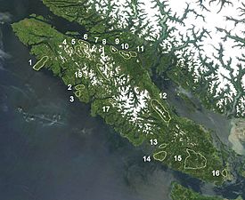
The Beaufort Range is a group of mountains found on the southern part of Vancouver Island in British Columbia, Canada. It's located north of a town called Port Alberni and west of Qualicum Beach. This mountain range covers an area of about 448 square kilometers. It's part of a larger group of mountains called the Vancouver Island Ranges, which are themselves part of the even bigger Insular Mountains.
Contents
About the Beaufort Range
The Beaufort Range is a notable feature of Vancouver Island's landscape. It stretches across a significant area, offering beautiful views and natural habitats. Mountain ranges are often formed over millions of years by powerful forces within the Earth.
Where is the Beaufort Range?
This mountain range is found on Vancouver Island, which is a large island off the west coast of Canada. It sits north of the city of Port Alberni. To its west is the community of Qualicum Beach. The range is a key part of the geography of this region.
Mount Joan: The Highest Peak
The tallest mountain in the Beaufort Range is called Mount Joan. It stands at a height of 1,556 meters (about 5,105 feet) above sea level. High peaks like Mount Joan are often popular for hiking and offer amazing views.
How the Range Got Its Name
The Beaufort Range was named after Sir Francis Beaufort. He was a very important person in the Royal Navy. Sir Francis Beaufort was a hydrographer. This means he was an expert in mapping and charting bodies of water, like oceans, seas, and rivers. His work helped sailors navigate safely around the world.
 | Isaac Myers |
 | D. Hamilton Jackson |
 | A. Philip Randolph |


