
Mount Benson (British Columbia) facts for kids
Quick facts for kids Mount Benson |
|
|---|---|

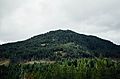
Mt. Benson viewed from the east at Duke Point
|
|
| Highest point | |
| Elevation | 1,023 m (3,356 ft) |
| Prominence | 668 m (2,192 ft) |
| Geography | |

Mount Benson
Location in British Columbia
|
|
| Parent range | Vancouver Island Ranges |
| Topo map | NTS 92F/01 |
Mount Benson is a mountain on Vancouver Island, British Columbia, Canada. It is about 9 kilometers (5.6 miles) west of the city of Nanaimo. Many local hikers enjoy climbing Mount Benson. From the top, you can see great views of the Strait of Georgia and the mainland coast of British Columbia.
This mountain was once called Wake-siah. In 1859, a man named Captain Richards named it after his friend, Alfred Robson Benson. Dr. Benson was a doctor who worked for the Hudson's Bay Company between 1857 and 1862.
The top of Mount Benson is mostly flat. It has a few small lakes and areas where trees have been cut down.
Contents
Exploring Mount Benson
Mount Benson is a popular spot for outdoor activities. Hikers love to explore its trails. Even though there used' to be a road to the top, it is now mostly accessed by foot.
What to See from the Summit
When you reach the top of Mount Benson, you get amazing views. You can look out over the Strait of Georgia, which is a large body of water. On clear days, you can even see the mainland coast of British Columbia far away. The flat summit area also has small lakes that add to the natural beauty.
Mount Benson Regional Park
In July 2008, a special area called the Mount Benson Regional Park was created. This park covers about 212 hectares (524 acres) on the upper northeast side of the mountain. The Regional District of Nanaimo and the Nanaimo and Area Land Trust bought the land in 2005.
Discovering the Park's Features
The park does not have road access, so you need to hike to get there. Only a part of the mountain is inside the park, and it does not include the very top twin peaks. The park is important because it is where the Millstone River and the Chase River begin. These rivers flow from the mountain's slopes.
Images for kids
-
Mount Benson viewed from Roberts Roost trail
.jpg)
