Comox Valley Regional District facts for kids
Quick facts for kids
Comox Valley
|
||
|---|---|---|
|
Regional district
|
||
| Comox Valley Regional District | ||
|
||

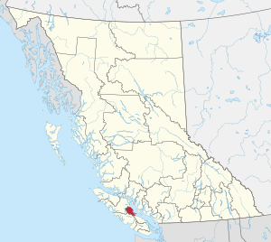
Location in British Columbia
|
||
| Country | Canada | |
| Province | British Columbia | |
| Administrative office location | Courtenay | |
| Government | ||
| • Type | Regional district | |
| • Body | Board of Directors | |
| Area | ||
| • Land | 1,699.90 km2 (656.34 sq mi) | |
| Population
(2016)
|
||
| • Total | 66,527 | |
| • Density | 39.1/km2 (101/sq mi) | |
| Website | comoxvalleyrd.ca | |
The Comox Valley Regional District (CVRD) is a special type of local government in British Columbia, Canada. It helps manage services for several communities in the area. The CVRD was created on February 15, 2008. It was formed from a larger district called the Comox-Strathcona Regional District.
Even though the new Comox Valley district is smaller in land area, it has most of the people. It covers about 2,425 square kilometers. About 1,725 square kilometers of this is land. In 2016, about 66,527 people lived here. The district is next to the Strathcona Regional District to the northwest. It also borders the Alberni-Clayoquot Regional District to the southwest. To the southeast is the Regional District of Nanaimo. Across the Strait of Georgia to the east is the Qathet Regional District.
Two Indian reserves, K'omoks Indian Reserve No. 1 and Puntledge Indian Reserve No. 2, are within this area. However, they are not under the CVRD's direct control. The Comox Valley Regional District includes the city of Courtenay, the town of Comox, and the village of Cumberland. It also includes three rural areas called Electoral Areas A, B, and C. The main offices for the district are in Courtenay, British Columbia.
Communities in the Comox Valley
The Comox Valley Regional District is made up of several different communities. Some are officially incorporated, meaning they have their own local governments. Others are unincorporated, which means they are directly managed by the regional district.
Incorporated Communities
These communities have their own local councils and mayors:
- Town of Comox
- City of Courtenay
- Village of Cumberland
Unincorporated Communities
These areas are represented by elected officials on the regional district board. They are divided into three "Electoral Areas."
Comox Valley Area A: Baynes Sound–Denman/Hornby Islands
This area is in the southern part of the district. It borders the Alberni-Clayoquot Regional District and the Regional District of Nanaimo.
Here are some facts about this area from the 2016 Canada Census:
- Population: 7,293 people
- Population Change (2011-2016): It grew by 4.5%
- Dwellings (homes): 4,360
- Area: 491.99 square kilometers
- Density (people per km²): 14.7 people per square kilometer
Communities in Area A
- Denman Island
- Fanny Bay
- Hornby Island
- Royston
- Union Bay
Comox Valley Area B: Lazo North
This area surrounds the town of Comox. It does not have its own local government. Instead, it sends representatives to the regional district board.
Here are some facts about this area from the 2016 Census:
- Population: 7,095 people (not including those on Indian Reserves)
- Population Change (2011–2016): It grew by 2.2%
- Dwellings (homes): 3,026
- Area: 54.28 square kilometers
- Density (people per km²): 117.9 people per square kilometer
Communities in Area B
- Balmoral Beach
- Bates Beach
- Grantham
- Lazo
- Little River
- Sandwick
Comox Valley Area C: Puntledge–Black Creek
This area is located between Courtenay, Campbell River, and Strathcona Provincial Park.
Here are some facts about this area from the 2016 Census:
- Population: 8,617 people (not including those on Indian Reserves)
- Population Change (2011–2016): It grew by 3.5%
- Dwellings (homes): 3,572
- Area: 1073.96 square kilometers
- Density (people per km²): 7.1 people per square kilometer
Communities in Area C
- Bevan
- Black Creek
- Headquarters
- Merville
- Mount Washington
- Puntledge
- Saratoga Beach
- Williams Beach
Getting Around: Transit
The Comox Valley Transit System is the local public transportation system. It helps people get around the region. A company called Watson and Ash Transportation operates it. The funding for this system comes from a partnership between the Comox Valley Regional District and BC Transit. BC Transit is a provincial agency that helps plan and manage transit systems across British Columbia.
 | Stephanie Wilson |
 | Charles Bolden |
 | Ronald McNair |
 | Frederick D. Gregory |

