Gabriola Island facts for kids
Quick facts for kids
Gabriola Island
|
|
|---|---|
|
Island
|
|
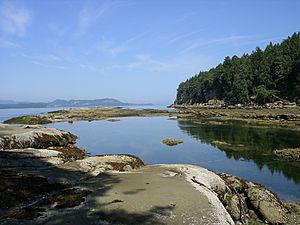
Beach at Descanso Bay
|
|
| Gabriola in the southern Gulf Islands | |
| Country | Canada |
| Province | British Columbia |
| Regional District | Regional District of Nanaimo |
| Area | |
| • Total | 57.6 km2 (22.2 sq mi) |
| Population
(2006)
|
|
| • Total | 4,050 |
| • Density | 70.3/km2 (182/sq mi) |
| Time zone | UTC−8 (Pacific Time Zone) |
| • Summer (DST) | UTC−7 (Pacific Daylight Time) |
| Postal code span |
V0R
|
| Area code(s) | 250 |
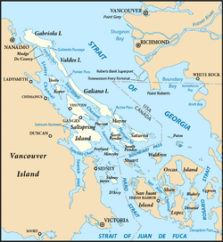
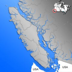
Gabriola Island is a beautiful island in British Columbia, Canada. It is one of the many Gulf Islands located in the Strait of Georgia. Gabriola is about 5 kilometers (3 miles) east of Nanaimo on Vancouver Island. A quick 20-minute ferry ride connects the two islands.
Gabriola Island covers about 57.6 square kilometers (22.2 square miles). Over 4,000 people live there all year round. The island has public beaches, forests, shops, restaurants, a library, and an elementary school. There is also a museum where you can learn about the island's past.
Gabriola is often called the "Isle of the Arts." Many artists live and work there. The island hosts many cultural events throughout the year. These include festivals for art, poetry, gardens, music, boating, and fishing. The Gabriola Arts Council organizes three big events each year: the Isle of the Arts Festival (April), Gabriola Theatre Festival (August), and the Thanksgiving Studio Tour (October).
Contents
Island History: A Look Back in Time
Early Days: Before European Contact
Gabriola Island is the traditional home of the Snuneymuxw First Nation. The city of Nanaimo gets its name from them. The oldest signs of people on Gabriola are from a cave burial. This burial dates back to about 1500 BCE (Before Common Era).
Many thousands of Snunéymux people lived in a village at False Narrows. This was between 0 and 1000 CE (Common Era). Archaeologists have found that people were very healthy back then. They lived well with their environment. Other smaller villages were found along the coast. After Europeans arrived, the Snunéymux population sadly dropped. This was due to diseases like smallpox.
The island is also famous for its petroglyphs. These are ancient carvings made in soft sandstone. They are believed to be thousands of years old. However, it's hard to know their exact age. These carvings are slowly wearing away because of the weather.
European Arrivals and Settlement
The first Europeans came to Gabriola in 1791. A Spanish ship called the Santa Saturnina visited the island. Its leader, José María Narváez, might have named the southeastern tip "Punta de Gaviola." This name might have later changed to "Gabriola" for the whole island.
In 1792, other Spanish explorers, Galiano and Valdés, also visited. They rested at a place they called Cala del Descanso ("Cove of Rest"). This spot is now known as Descanso Bay. The British explorer George Vancouver may have also stopped by in 1792. The Spanish explored the area but did not build lasting settlements.
In 1827, fur traders from the Hudson's Bay Company set up a trading post. This was at Fort Langley on the Fraser River. But no Europeans settled near Nanaimo until coal was found there in 1852. After that, coal miners and former gold miners started moving to Gabriola. They began farming to provide food for Nanaimo's growing population.
By 1874, 17 families lived and farmed on Gabriola. Many of these settlers had First Nations wives and children. For example, John Silva, a Portuguese settler, married "Louise" in 1873. She was the daughter of a Cowichan chief. Silva Bay is named after John Silva.
Growth and Change on the Island
In the early 1900s, Gabriola's population grew slowly. By the 1950s, fewer than 400 people lived there full-time. Electricity came to the island in 1955. Even then, the population grew slowly until the 1970s. In the next 10 years, the population tripled. Many people moved there looking for a simpler life. By the mid-1980s, about 2,000 people lived on Gabriola.
During summer, the island's population gets much bigger. Families from Nanaimo and Vancouver have always come to Gabriola for simpler, rural vacations. Today, about 2,000 "summer people" visit Gabriola each year. They come for the sun, music, art, and relaxed pace. This makes the summer population around 6,000 people.
Gabriola also had some industries in the 1900s. A brickyard made 80,000 high-quality bricks every day. These bricks were sent to Victoria and Vancouver. The brickyard closed in the 1950s. Sandstone blocks were also cut from a quarry near Descanso Bay. They were used in buildings in Vancouver and Victoria. Later, millstones were cut from the sandstone. They were used in paper mills as far away as Finland. After World War II, the shipyard at Silva Bay became the main employer. It stayed important until the 1970s.
Island Geography: Exploring Gabriola's Landscape
Gabriola is part of the Regional District of Nanaimo. It is the most northern of the Southern Gulf Islands. These islands are located in the Strait of Georgia. This strait is between mainland British Columbia and Vancouver Island. The Gulf Islands are a group of hundreds of islands. They stretch from the San Juan Islands in the United States to the Northern Gulf Islands.
The Southern Gulf Islands were once part of the seabed. They were pushed up by moving tectonic plates millions of years ago. Later, glaciers scraped away soil and rock. During the Fraser Glaciation, Gabriola was covered by ice up to 2 kilometers (1.2 miles) thick. When the glaciers melted, they left behind sand, gravel, and boulders. The main rocks you see on Gabriola are sandstone and shale. The different hardness of these rocks created the cliffs, points, and bays along the shoreline.
Gabriola is about 14 kilometers (8.7 miles) long. It is about 4.2 kilometers (2.6 miles) wide on average. Its total land area is 57.6 square kilometers (22.2 square miles). The island's land goes from flat sandy beaches to forested hills. The highest point is Stoney Ridge, which is 160 meters (525 feet) high.
Gabriola is about 5 kilometers (3 miles) east of Nanaimo. Nanaimo is the second-largest city on Vancouver Island. You can get to Gabriola by BC Ferries. The ferry ride takes 20 minutes and runs almost every hour. It starts early in the morning from Gabriola and runs until late at night from Nanaimo. Many Gabriola residents use the ferry to go to work or high school in Nanaimo. You can also reach Gabriola by float plane or small boat.
Islands and small islets near Gabriola include Snake Island and Entrance Island to the north. To the east are the Flat Top Islands, Breakwater Island, and Valdes Island. To the south are Mudge Island, Link Island, and De Courcy Island. The main road on Gabriola is a 30-kilometer (18.6-mile) loop called North Road-South Road. It passes near most parts of the island, including the ferry terminal at Descanso Bay.
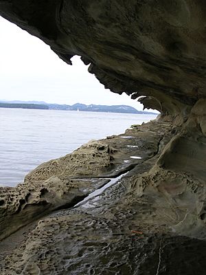
Gabriola has three provincial parks: Gabriola Sands Provincial Park, Sandwell Provincial Park, and Drumbeg Provincial Park. There is also Descanso Bay Regional Park and a community park near the ferry. These parks protect beautiful natural areas. The large sandstone formations known as the Malaspina Galleries are in the community park. They were named after the 18th-century Spanish explorer Alejandro Malaspina.
Island Life: Community and Fun
Gabriola Island is a lively place with many events. The Gabriola Arts Council puts on three big festivals. These are the Isle of the Arts Festival in April, the Gabriola Theatre Festival in August, and the Thanksgiving Weekend Studio and Gallery Tour. Another fun event is the Shipyard School "Launch Festival" in Silva Bay. It celebrates students who learn to build traditional wooden boats. The Concert on the Green and the Annual Salmon Barbecue happen in August.
From May to October, there's a great Saturday Market at the Agricultural Hall. You can find local produce, baked goods, crafts, and artwork from the island. Habonim Dror Camp Miriam, a Jewish summer camp, runs on the island during the summer months.
Folklife Village is the island's main shopping center. It's on North Road, a short drive from the ferry terminal. This village was actually part of Expo 86 in Vancouver. It was moved to Gabriola after the event. Other shopping areas are at Twin Beaches Mall and Silva Bay. Gabriola residents often call the island "Gabe." They call Vancouver Island "The Big Island" and Vancouver "The Mainland."
Gabriola and nearby islands have over 70 known petroglyphs. These are ancient carvings in sandstone. Some might be as old as 2,000 years or more. The Gabriola Museum has a small park with copies of some of these amazing petroglyphs.
Nature's Wonders: Plants and Animals
Gabriola Island is home to many different plants and animals.
Trees and Shrubs
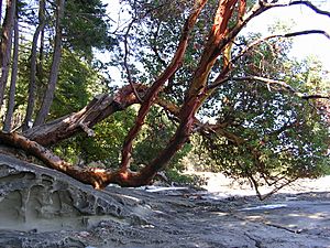
Common trees on the island include the Douglas fir, Western red cedar, arbutus, Garry oak, big leaf maple, and red alder. You can also find shrubs like Oregon-grape and red-flowering currant. Other plants include the small camas flower, Western skunk cabbage, and the Western swordfern.
Marine Life and Land Animals
The waters around Gabriola are full of sea creatures. You might spot orcas (killer whales), sea lions, seals, and otters. There are also oysters, mussels, clams, wolf eels, octopuses, and salmon. On land, deer and raccoons are common animals you might see.
Birds of Gabriola
In winter, many types of waterfowl visit Gabriola's coast. These include scoters, buffleheads, Barrow's goldeneyes, and harlequin ducks. Shorebirds like the black turnstone and ruddy turnstone are also often seen. Garden birds like the ruby-crowned kinglet, golden-crowned kinglet, thrushes, warblers, pileated woodpeckers, and flickers live here. You can see bald eagles, common ravens, European starlings, peafowl, and wild turkeys all year round. More than 250 different bird species live in or visit the Nanaimo–Gabriola area.
Climate: Gabriola's Weather
Gabriola Island has a cool summer Mediterranean climate. This means it has dry summers. The island gets about 138 rainy days each year. Snowfall is rare, with only about seven days getting more than 0.2 centimeters (0.08 inches) of snow.
Hot days above 30°C (86°F) are very rare, usually less than one per year. Cold days below 0°C (32°F) happen about 25 times a year. Winters are cool and wet. The average temperature in January is 3.7°C (38.7°F). It gets about 130 millimeters (5.1 inches) of rain in January. Because winters are mild, the average yearly snowfall is low, around 40 centimeters (15.7 inches). Summers are dry and mild. The average temperature in July is 16.9°C (62.4°F), with only about 26 millimeters (1 inch) of rain.
| Climate data for Gabriola Island | |||||||||||||
|---|---|---|---|---|---|---|---|---|---|---|---|---|---|
| Month | Jan | Feb | Mar | Apr | May | Jun | Jul | Aug | Sep | Oct | Nov | Dec | Year |
| Record high °C (°F) | 14.5 (58.1) |
15.0 (59.0) |
20.5 (68.9) |
25.0 (77.0) |
31.0 (87.8) |
30.0 (86.0) |
32.0 (89.6) |
31.0 (87.8) |
30.0 (86.0) |
24.0 (75.2) |
18.0 (64.4) |
13.5 (56.3) |
32.0 (89.6) |
| Mean daily maximum °C (°F) | 6.6 (43.9) |
7.7 (45.9) |
10.0 (50.0) |
13.0 (55.4) |
16.6 (61.9) |
19.3 (66.7) |
22.2 (72.0) |
22.3 (72.1) |
19.2 (66.6) |
13.4 (56.1) |
8.8 (47.8) |
6.0 (42.8) |
13.8 (56.8) |
| Daily mean °C (°F) | 3.7 (38.7) |
4.3 (39.7) |
6.1 (43.0) |
8.5 (47.3) |
11.7 (53.1) |
14.4 (57.9) |
16.9 (62.4) |
16.8 (62.2) |
13.8 (56.8) |
9.3 (48.7) |
5.6 (42.1) |
3.3 (37.9) |
9.5 (49.1) |
| Mean daily minimum °C (°F) | 0.8 (33.4) |
0.8 (33.4) |
2.2 (36.0) |
4.0 (39.2) |
6.6 (43.9) |
9.6 (49.3) |
11.4 (52.5) |
11.2 (52.2) |
8.4 (47.1) |
5.1 (41.2) |
2.4 (36.3) |
0.6 (33.1) |
5.3 (41.5) |
| Record low °C (°F) | −16.0 (3.2) |
−12.0 (10.4) |
−6.0 (21.2) |
−4.0 (24.8) |
−2.0 (28.4) |
2.0 (35.6) |
4.0 (39.2) |
4.5 (40.1) |
0.0 (32.0) |
−4.5 (23.9) |
−14.0 (6.8) |
−15.0 (5.0) |
−16.0 (3.2) |
| Average precipitation mm (inches) | 129.8 (5.11) |
105.9 (4.17) |
86.9 (3.42) |
57.0 (2.24) |
44.9 (1.77) |
40.9 (1.61) |
26.0 (1.02) |
28.2 (1.11) |
38.5 (1.52) |
81.3 (3.20) |
146.9 (5.78) |
137.8 (5.43) |
924.0 (36.38) |
| Average rainfall mm (inches) | 116.1 (4.57) |
96.8 (3.81) |
85.1 (3.35) |
57.0 (2.24) |
44.9 (1.77) |
40.9 (1.61) |
26.0 (1.02) |
28.2 (1.11) |
38.5 (1.52) |
80.9 (3.19) |
143.0 (5.63) |
126.9 (5.00) |
884.3 (34.81) |
| Average snowfall cm (inches) | 13.7 (5.4) |
9.1 (3.6) |
1.8 (0.7) |
0 (0) |
0 (0) |
0 (0) |
0 (0) |
0 (0) |
0 (0) |
0.3 (0.1) |
3.9 (1.5) |
10.9 (4.3) |
39.7 (15.6) |
| Average precipitation days (≥ 0.2 mm) | 16.5 | 14.1 | 14.4 | 12.5 | 10.7 | 9.2 | 5.9 | 5.7 | 7.3 | 12.2 | 17.2 | 16.4 | 142.0 |
| Average rainy days (≥ 0.2 mm) | 15.0 | 13.3 | 14.3 | 12.5 | 10.7 | 9.2 | 5.9 | 5.7 | 7.3 | 12.1 | 16.7 | 15.2 | 137.9 |
| Average snowy days (≥ 0.2 cm) | 2.3 | 1.3 | 0.37 | 0 | 0 | 0 | 0 | 0 | 0 | 0.07 | 0.70 | 1.9 | 6.7 |
| Source: Environment Canada | |||||||||||||
See also
 In Spanish: Isla Gabriola para niños
 | John T. Biggers |
 | Thomas Blackshear |
 | Mark Bradford |
 | Beverly Buchanan |


