Cowichan Tribes facts for kids
Quick facts for kids
Cowichan First Nation
Quw’utsun
Band number 642
|
|
|---|---|
| Country | |
| Government | |
| • Type | First Nations Council |
| Population
(Feb 2015)
|
|
| • Total | 4,778 |
| 1,234 males, 1,217 females on reserve. Remainder live off reserve | |
| Time zone | UTC-8 (Pacific Time Zone (PTZ)) |
| • Summer (DST) | DST |
| Postal code span |
V9L 5J1
|
| Area code(s) | 250 |
| Main Office: 5760 ALLENBY ROAD, Duncan, British Columbia | |
The Cowichan Tribes (also known as Quw’utsun) are a large group of Coast Salish people. They live in the Cowichan Valley on Vancouver Island in British Columbia, Canada. With over 3,800 registered members, they are the biggest First Nations group in British Columbia.
When the Canadian government created "bands" under the Indian Act, seven nearby groups joined together to form the Cowichan Tribes. The largest of these groups is the Quamichan (or Kw'amutsun). The nation also includes the Clemclemaluts, Comiaken, Khenipsen, Kilpahlas, Koksilah, and Somena peoples.
Contents
Exploring the Cowichan Traditional Territory
The Cowichan people have lived in their traditional territory for a very long time. This area covers the entire Cowichan Valley, including Cowichan Lake and Shawnigan Lake. It also reaches into the Gulf Islands and the Fraser River. The lower part of the Cowichan Valley, especially near Duncan and Cowichan Bay, was where most people lived.
Today, the Cowichan Tribes have a total reserve area of about 24 square kilometres (5,900 acres). This land is made up of nine different reserves. Their larger traditional territory is about 1,750 square kilometres (100,000 acres).
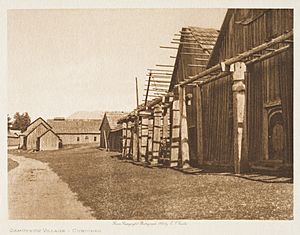
Traditional Cowichan Villages
The Cowichan Tribes are made up of seven traditional villages. These villages are important parts of their history and culture:
- Quamichan (also called Kwa’mutsun)
- Comiaken (also called Qw’umiyiqun')
- Koksilah (also called Xwulqw’selu')
- Somena (also called S’amuna')
- Clemclemluts (also called Lhumlhumuluts')
- Khenipsen (also called Xinupsum')
- Cowichan Bay (also called Tl'lulpalus')
Understanding Cowichan Reserves
Indian Reserves are special areas of land set aside for First Nations people in Canada. The Cowichan Tribes manage nine of these reserves. Each reserve has its own unique location and history:
- Cowichan 1: This is a large area of land in the Cowichan District.
- Theik 2 (or Thiq): Located on the south shore of Cowichan Bay.
- Kil-pah-las 3 (or Tl'lulpalus): Also on the south shore of Cowichan Bay.
- Est-Patrolas 4 (or Quli’lum): About two miles south of Cowichan Bay.
- Tzart-lam 5 (or Ts’alha’um): Found on the left bank of the Cowichan River.
- Kakalatza 6 (or Quyxuletse’): Also on the left bank of the Cowichan River.
- Skutz 7 (or Skwutz): Located on the Cowichan River at Skutz Canyon.
- Skutz 8 (or Skwutz): Further up the Cowichan River, at the head of Skutz Canyon.
- Cowichan 9: Near where the Koksilah River meets Cowichan Bay.
How Cowichan Tribes are Governed
The Cowichan Tribes are led by an elected council. This council includes a chief and 12 councillors. They work within the rules of the Indian Act. The Cowichan Tribes are also part of the Hul'qumi'num Treaty Group. This group is working on a treaty with the Canadian government.
The band council is in charge of many important services for their community. These include programs for children and families, education, health care, housing, and social development.
Cowichan Tribes Businesses
The Cowichan Tribes own and run a group of companies called the Khowutzun Development Corporation (KDC). These businesses help create jobs and support the community. In 2004, these companies earned about $60 million.
Some of their businesses include:
- Khowutzun Mustimuhw Contractors Limited Partnership (KMCLP)
- Khowutzun Forest Services Limited Partnership (KFCLP)
- Khowutzun Millwork & Joinery Limited Partnership (KMJLP)
- Quw'utsun Cultural and Conference Centre (QCCC)
The Cowichan Tribes are also very famous for their special way of knitting. They are especially known for making beautiful Cowichan sweaters.
 | Laphonza Butler |
 | Daisy Bates |
 | Elizabeth Piper Ensley |


