Saanich Inlet facts for kids
Quick facts for kids Saanich Inlet |
|
|---|---|
| French: Baie Saanich | |

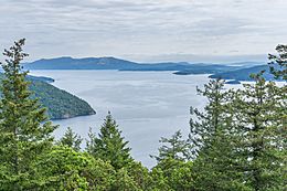
Saanich Inlet from Gowlland Tod Provincial Park
|
|
| Location | Northwest of Victoria, British Columbia |
| Coordinates | 48°37′33″N 123°30′26″W / 48.62583°N 123.50722°W |
| Type | Fjord |
| River sources | Goldstream River |
| Basin countries | |
| Max. length | 25 km (16 mi) |
| Surface area | 67 km2 (26 sq mi) |
| Max. depth | 226 m (741 ft) |
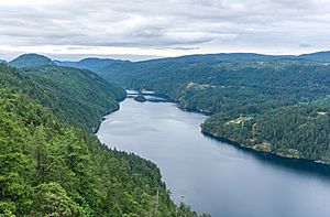
Saanich Inlet is a long, narrow arm of the ocean, also known as a fjord. It is located on Vancouver Island in British Columbia, Canada. This special body of salt water is found northwest of the city of Victoria. It stretches about 25 kilometers (15 miles) long and can be as deep as 226 meters (741 feet).
The inlet lies between the Saanich Peninsula and the Malahat highlands. It connects to the Satellite Channel in the north and extends south to Squally Reach and Finlayson Arm. The only major river that flows into Saanich Inlet is the Goldstream River.
A Special Place for People
For hundreds of years, Saanich Inlet has been important for fishing. The Malahat and Saanich First Nations have traditionally fished here. Many of their reserves are located along the shoreline.
After Europeans arrived, the inlet also became popular for fishing for fun and for business. It is also a favorite spot for SCUBA diving. In the past, there was a port at Bamberton on the western shore. This port served a cement factory.
Unique Ocean Conditions
Most of the year, the deep waters of Saanich Inlet have very little oxygen. This condition is called anoxic. Sometimes, a gas called hydrogen sulfide (H2S) can be found near the bottom.
However, in the late summer and early fall, something interesting happens. Oxygen-rich waters from the Haro Strait and the Satellite Channel flow into the deeper parts of Saanich Inlet. This brings fresh oxygen to the anoxic waters.
Exploring the Bays and Arms
Saanich Inlet has several interesting bays and smaller inlets connected to it:
- Brentwood Bay: This is a calm, protected bay on the east side of the inlet. A small ferry service connects it to Mill Bay.
- Tod Inlet: This smaller inlet branches off Brentwood Bay. It provides water access to Gowlland Tod Provincial Park and the community of Willis Point. It is also near the famous Butchart Gardens.
- Coles Bay
- Deep Cove
- Finlayson Arm: This is a long, narrow arm at the south end of the inlet. The Goldstream River flows into it at Goldstream Provincial Park. The scenic Malahat Drive runs along the west side of Finlayson Arm.
- Mill Bay: This is a calm bay and community on the west side of the inlet. The ferry from here to Brentwood Bay offers a way to travel to Greater Victoria without driving the steep Malahat Drive.
- Patricia Bay: This is a very deep bay. It is home to the Institute of Ocean Sciences, a research facility.
- Squally Reach: This channel connects the main Saanich Inlet to Finlayson Arm.
- McKenzie Bight: This is an easy-to-sail area on the east side of Saanich Inlet, where it meets Squally Reach.
Other notable places around the inlet include:
- Mount Finlayson
- Bamberton
 | Jessica Watkins |
 | Robert Henry Lawrence Jr. |
 | Mae Jemison |
 | Sian Proctor |
 | Guion Bluford |


