Mount Finlayson facts for kids
Quick facts for kids Mount Finlayson |
|
|---|---|

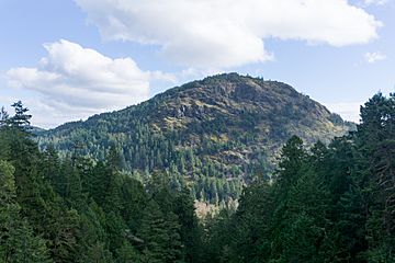
The west face of Mount Finlayson
|
|
| Highest point | |
| Elevation | 419 m (1,375 ft) |
| Prominence | 407 m (1,335 ft) from parking lot |
| Geography | |
| Location | Vancouver Island, British Columbia, Canada |
| Parent range | Gowlland Range |
| Topo map | NTS 92B/05 |
Mount Finlayson is a cool mountain in British Columbia, Canada. It stands about 419 meters (or 1,375 feet) tall. That's like climbing a really big building! It sits right on the edge of two towns, Highlands and Langford.
This mountain is part of the Gowlland Range. It's also very close to two awesome places: Goldstream Provincial Park and Gowlland Tod Provincial Park. If you're driving south on Highway 1, you can see Mount Finlayson looking huge above Saanich Inlet.
Exploring Mount Finlayson
Mount Finlayson is a popular spot for outdoor adventures. It's known for its challenging trails and amazing views. Many people enjoy hiking to the top.
Where is it?
Mount Finlayson is located on Vancouver Island. It's about 14 kilometers (or 9 miles) northwest of Victoria. This makes it easy to visit if you are in the area.
Hiking to the Top
Getting to the summit of Mount Finlayson is an exciting hike. There's a steep trail that starts from Goldstream Provincial Park. It's a great way to get some exercise and enjoy nature. You can also find trails that connect to the summit from Bear Mountain. These trails offer different ways to explore the mountain.
Amazing Views
Once you reach the top of Mount Finlayson, you'll be rewarded with incredible sights. You can see the whole Greater Victoria area spread out below. On a clear day, you might even spot the Strait of Juan de Fuca. Beyond that, you can see the Olympic Mountain range in the distance. And if you're lucky, you might even catch a glimpse of Mount Baker, a famous volcano.
 | Shirley Ann Jackson |
 | Garett Morgan |
 | J. Ernest Wilkins Jr. |
 | Elijah McCoy |

