Haro Strait facts for kids
Quick facts for kids Haro Strait |
|
|---|---|
| French: Détroit de Haro | |

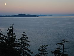
View of Haro Strait from South Pender Island
|
|

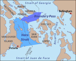
Map of Haro Strait and Boundary Pass according to USGS definitions
|
|
| Location | British Columbia and Washington |
| Coordinates | 48°33′N 123°13′W / 48.550°N 123.217°W |
| Type | Strait |
| Part of | Salish Sea |
| Basin countries | Canada and United States |
| Max. length | 36 km (22 mi) |
| Max. width | 19 km (12 mi) |
| Settlements | Victoria, Saanich, Sidney |
Haro Strait is a very important waterway that connects two larger bodies of water: the Strait of Georgia and the Strait of Juan de Fuca. It separates Vancouver Island and the Gulf Islands in British Columbia, Canada, from the San Juan Islands in Washington state, United States.
This strait is a key part of the international border between Canada and the United States. It was chosen as the boundary after a disagreement called the San Juan Islands dispute (also known as the Pig War). Haro Strait was picked over another channel, Rosario Strait, which is located to the east of the San Juan Islands.
Contents
What is Haro Strait?
The USGS helps us understand exactly where Haro Strait begins and ends. To the south, it connects with the Strait of Juan de Fuca. The line between them runs from Discovery Island (near Victoria) to Cattle Point on the southern tip of San Juan Island.
To the north, Haro Strait connects to Boundary Pass. This northern boundary runs from the tip of the Saanich Peninsula through several islands like Piers Island, Portland Island, and Moresby Island. It then continues from Point Fairfax on Moresby Island to Turn Point on Stuart Island, and finally to Mitchell Bay on San Juan Island. This means Haro Strait doesn't directly meet the Strait of Georgia; instead, the main channel and international border go through Boundary Pass to reach it.
History of Haro Strait
Long ago, Haro Strait and the waters around the Gulf Islands and San Juan Islands were home to various Indigenous peoples, including the Lummi, Saanich, and Klallam. This waterway was very important for trade and travel for all the marine peoples of the Northwest Coast.
The strait got its name in 1790 from Manuel Quimper. He was the commander of a ship called Princesa Real and named it after his pilot, Gonzalo López de Haro. Another idea is that it was named after Alonso Núñez de Haro y Peralta, who was an Archbishop in Mexico.
In 1791, Francisco de Eliza sent José María Narváez to explore deep into the Strait of Georgia using Haro and Rosario Straits. A year later, in 1792, George Vancouver also explored and mapped Haro Strait.
The exact location of the international border in Haro Strait was decided in 1870 after the San Juan Islands dispute. The German Kaiser Wilhelm I was asked to make the final decision. He chose Haro Strait over Rosario Strait, which the British had preferred. If Rosario Strait had been chosen, the San Juan Islands would have become part of British Columbia.
Haro Strait is also very important for fishing. Most of the Fraser River salmon run (when salmon swim upstream to lay eggs) uses Haro Strait to enter the river. D'Arcy Island, on the Canadian side, was once a place where sick Chinese immigrants lived in the 1800s.
Haro Strait is a major shipping route. It is one of the busiest and westernmost channels that connect the Strait of Juan de Fuca and the Strait of Georgia. Haro Strait meets Boundary Pass at Turn Point on Stuart Island, where a very important navigation light, Turn Point Light, is located.
It's important to know that strong and dangerous currents, called rip tides, can happen near Turn Point. They also occur near the northern end of Boundary Pass, between Patos Island Light on Patos Island and East Point on Saturna Island.
Haro Strait is shorter than Rosario Strait, but it can be harder to navigate and offers less shelter from the weather. Despite this, it is the main shipping channel for ships heading to the Port of Vancouver and other ports around the Strait of Georgia from the open ocean. Canadian ships are allowed to use these American waters for commercial shipping because of an agreement called the Oregon Treaty.
Amazing Marine Life
Haro Strait is a favorite spot for whale-watching tours. Many people come from Victoria and the San Juan Islands to see the incredible variety of marine life here. You can often spot orcas (also known as killer whales), sea lions, seals, and many different kinds of sea birds. It's a truly lively place for ocean animals!
See also
 In Spanish: Estrecho de Haro para niños
 | Tommie Smith |
 | Simone Manuel |
 | Shani Davis |
 | Simone Biles |
 | Alice Coachman |


