Rosario Strait facts for kids

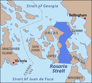
Rosario Strait is a narrow waterway in northern Washington State. It separates parts of San Juan County from Skagit and Whatcom Counties. This strait stretches about 23 kilometers (14 miles) north, connecting the Strait of Juan de Fuca to the Strait of Georgia.
The USGS helps define the strait's edges. Its southern part runs from Point Colville on Lopez Island to Rosario Head on Fidalgo Island. To the north, it goes from Point Migley on Lummi Island to the east tip of Puffin Island, then to Point Thompson on Orcas Island. Rosario Strait flows between several islands. On the west are Lopez, Decatur, Blakely, and Orcas Islands. On the east are Fidalgo, Cypress, Sinclair, and Lummi Islands.
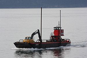
Rosario Strait is a very busy shipping lane. Many large ships, including oil tankers, travel through it every year. These ships go to and from refineries near Anacortes and Cherry Point. Other vessels also use the strait to reach places like Bellingham and the San Juan Islands. Sometimes, ships heading to British Columbia or Alaska choose this strait. They do this because the tidal currents can help them travel faster.
History of Rosario Strait's Name
The history of Rosario Strait's name is quite interesting. In 1790, Spanish explorers Manuel Quimper and Juan Carrasco sailed here on the ship Princesa Real. They first thought the strait was a bay and named it Boca de Fidalgo, honoring Salvador Fidalgo.
A year later, in 1791, José María Narváez explored more. He realized it was a strait, not a bay, and renamed it Canal de Fidalgo. Also in 1791, Francisco de Eliza gave a very long name, Gran Canal de Nuestra Señora del Rosario la Marinera, to what we now call the Strait of Georgia.
In 1792, the British explorer George Vancouver came to the area. He named the Strait of Georgia after King George III. However, he did not give a name to Rosario Strait itself.
Later, in 1847, Charles Wilkes led the United States Exploring Expedition. He named Rosario Strait "Ringgold Channel" after one of his officers. But in the same year, British Captain Henry Kellett updated the British maps. He removed many "pro-American" names given by Wilkes. Kellett kept British and Spanish names. He confirmed Vancouver's name for the Strait of Georgia. Then, he used a shorter version of Eliza's original name for the Strait of Georgia to name Rosario Strait. This is how it got its current name.
Important Waterway for Borders
After the Oregon Treaty was signed, people needed to decide on the border between the United States and British territories. The border was set at the 49th Parallel, which ended in the middle of the Strait of Georgia. The British thought Rosario Strait was the best route to the open ocean from this border point. It was indeed the shortest shipping path.
However, the Americans preferred Haro Strait, which is west of the San Juan Islands. Haro Strait is wider, though a bit longer. This disagreement over which strait should be the border led to a small conflict called the Pig War. Eventually, after some discussion, Haro Strait was chosen as the boundary.
See also
 In Spanish: Estrecho Rosario para niños
 | DeHart Hubbard |
 | Wilma Rudolph |
 | Jesse Owens |
 | Jackie Joyner-Kersee |
 | Major Taylor |


