Lopez Island facts for kids

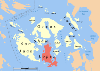
Location of Lopez Island in the San Juans
|
|
| Geography | |
|---|---|
| Location | Pacific Northwest |
| Coordinates | 48°28′44″N 122°53′31″W / 48.47889°N 122.89194°W |
| Archipelago | San Juan Islands |
| Area | 29.81 sq mi (77.2 km2) |
| Administration | |
|
United States
|
|
| State | Washington |
| County | San Juan County |
| Demographics | |
| Population | 3,156 (2020) |
Lopez Island is the third largest island in the San Juan Islands. It is a community in San Juan County, Washington, United States. Lopez Island covers about 29.81 square miles (77.2 square kilometers) of land. In 2020, about 3,156 people lived there. However, many more people visit in the summer. This is because many vacation homes, rentals, and campsites fill up.
Contents
History of Lopez Island

Long ago, the ancestors of today's Northern Straits Coast Salish people arrived here. This was after a huge ice sheet melted away about 11,000 years ago. Scientists have found signs that people hunted and gathered food on the island between 6,000 and 8,000 years ago.
About 2,500 years ago, a strong culture based on the sea developed. The first Europeans who came to this area saw this culture. You can still find traces of their old villages, like shell mounds, along the shorelines.
How Lopez Island Got Its Name
During an exploration trip called the Wilkes Expedition, Lopez Island was first named Chauncey Island. It was named after an American naval leader, Isaac Chauncey. Later, in 1847, the British changed their official navy maps. Henry Kellett removed many of the names given by Wilkes.
He renamed the island Lopez. This new name honored Gonzalo López de Haro. He was a Spanish naval officer. He was the first European to sail to the San Juan Islands.
Lopez Island Historical Museum
The Lopez Island Historical Museum collects and saves the history of Lopez and the San Juan Islands. The museum shows items that tell about Lopez's past in fishing, farming, and sea travel. It also has many old documents and items that show what life was like on Lopez Island in the late 1800s and early 1900s.
People of Lopez Island
In 2010, there were 2,383 people living on Lopez Island. Most residents were White (93.6%). About 12.9% of the people were under 18 years old. A larger group, 28.7%, were 65 years old or older. The average age was about 57 years.
Geography of Lopez Island
Lopez Island is flatter than most of the other big San Juan Islands. It feels more like the countryside compared to other larger islands. You can find rolling hills, forests, farms, and beaches here. The island is longer from north to south.
Lopez Island Climate
Lopez Island has warm and dry summers. The average monthly temperatures do not go above 71.6°F (22°C). This type of weather is called a warm-summer Mediterranean climate. On climate maps, it is known as "Csb."
Getting Around Lopez Island
There are no big highways on Lopez Island. Also, there are no bridges connecting it to the mainland or other islands. The main way to get to and from Lopez Island is by ferry. The ferry terminal is at the very north end of the island.
It is the first stop on the Washington State Ferries route for the San Juan Islands. A ferry ride from Anacortes usually takes about 40 minutes.
Air Travel to Lopez Island
Lopez Island Airport is the main airport on the island. It is on the west side and has daily commercial flights. You can also take charter floatplanes that land in Fisherman Bay. This is at the Fisherman Bay Seaplane Base. There is also a small private airstrip called Windsock Airport. It is close to the ferry terminal.
Economy and Fun on Lopez Island
Lopez Island has many businesses for tourists. These include country-style bed and breakfasts and rental homes, often with ocean views. There is a vineyard, a hotel, two public marinas, and several restaurants and cafes. You can also find a small bookstore and two coffee shops.
During the summer, the Saturday Market in Lopez Village is a popular spot. It offers arts and crafts, fresh local farm produce, and community activities.
Biking on Lopez Island
Lopez Island is a great place for bicycle tourists. Drivers on the island are generally friendly to bikes. The roads are easier to ride than those on other San Juan Islands because speed limits are lower. However, bikers are advised to avoid Center Road, as it is not as wide as other roads.
The Lopez Wave
The island is famous for a special custom: people wave at every driver, biker, or walker they meet on the roads. It's a friendly tradition!
Parks on Lopez Island
Lopez Island has several parks, each with different features. Agate Beach County Park, Odlin County Park, and Otis Perkins Day Parks are all beach areas. They are great for picnics. Agate Beach is on the south end of the island. Odlin is one of the most popular beaches. It is just south of the Ferry Landing and has camping spots and a boat launch. The beach at Otis Perkins is one of the longest beaches in the San Juan Islands.
Hiking Parks
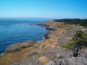
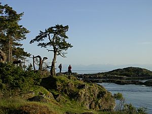
Two parks offer short hikes. Shark Reef Park has great views west over San Juan Channel. It has a half-mile trail that goes through some old, tall trees. Upright Channel Park is run by the state. It has picnic spots and a trail down to a sandy beach.
Spencer Spit State Park
The biggest park on the island is Spencer Spit State Park. It is on the northeast side of the island. The main feature is a long, low sandspit. This sandspit almost connects to a small island called Frost Island, which is just offshore. This park is 130 acres (53 hectares) and has a camping area, picnic spots, and places for boats to tie up.
Media
- KLOI-LP - This is a local low-power FM radio station based on Lopez Island.
See also
 In Spanish: Isla López para niños
 | Toni Morrison |
 | Barack Obama |
 | Martin Luther King Jr. |
 | Ralph Bunche |


