Orcas Island facts for kids
|
Nickname: Gem of the San Juan Islands
|
|
|---|---|

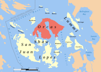
Location of Orcas Island in the San Juan Islands
|
|
| Geography | |
| Location | Pacific Northwest |
| Coordinates | 48°39′15″N 122°56′18″W / 48.65417°N 122.93833°W |
| Archipelago | San Juan Islands |
| Area | 57.3 sq mi (148 km2) |
| Highest elevation | 2,409 ft (734.3 m) |
| Highest point | Mount Constitution |
| Administration | |
|
United States
|
|
| State | Washington |
| County | San Juan County |
| Largest settlement | Eastsound |
| Demographics | |
| Population | 5,387 (2010) |
| Pop. density | 30.09 /km2 (77.93 /sq mi) |
Orcas Island is the largest of the San Juan Islands. These islands are located in the Pacific Northwest part of Washington, United States.
Contents
History and Naming of Orcas Island

The name "Orcas" comes from Horcasitas. This was a shortened form of the name of Juan Vicente de Güemes Padilla Horcasitas y Aguayo. He was a Spanish leader who sent an exploration trip to the Pacific Northwest in 1791.
During this trip, explorer Francisco de Eliza looked at parts of the San Juan Islands. He didn't name Orcas Island specifically. Instead, he used the name for a larger group of islands.
In 1847, Henry Kellett officially named Orcas Island. He was updating British maps. Before this, an American explorer named Charles Wilkes had given many places American names. For example, he called Orcas Island "Hull Island." He also named East Sound "Ironsides Inlet" and West Sound "Guerrier Bay."
One of Wilkes's names that is still used today is Mount Constitution. These names honored American heroes and ships from the War of 1812.
The islands were first claimed by Spain. Then, Britain also claimed them. After the War of 1812, Britain and the U.S. agreed that land below the 49th parallel was part of the U.S. However, there were still arguments over the San Juan Islands. These arguments, including the Pig War (1859), were not settled until 1871.
It's interesting that the island's name sounds like "orca," the whale. But this is just a coincidence! The island was not named after the animal.
Geography of Orcas Island
Orcas Island covers about 57.3 square miles (148.4 square kilometers). About 6,000 people lived there in 2020. It is a bit bigger than nearby San Juan Island, but has fewer people.
The island looks a bit like a pair of saddlebags. It is split by a narrow, deep inlet called Eastsound. There are also two large bays on the southwest side: Westsound and Deer Harbor.
The biggest village on Orcas Island is Eastsound. It is located at the northern end of the island. Eastsound is also the second largest town in San Juan County.
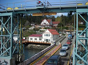
Other smaller communities on the island include Orcas Landing. This is where the ferry lands. You can also find West Sound, Deer Harbor, Rosario, Olga, and Doe Bay. Some old settlements that were once busy with lime production or fruit growing no longer exist.
How to Get to Orcas Island

The state of Washington helps people get to the island using the Washington State Ferries system. You can also reach Orcas Island by air, seaplane, or private boat.
There are public docks near the villages for private boats. You can also find many public spots to access the shoreline. During the summer, a shuttle van runs from the ferry landing to Eastsound and other places on the island.
Arts and Culture
Historic Sites
Orcas Island has two museums. The Orcas Island Historical Museum is in downtown Eastsound. It tells the story of the island with about 6,000 items, documents, and photos. The Crow Valley School Museum is a one-room school house built in 1888. You can visit it by appointment.
Rosario Resort was started in 1906 by Robert Moran. He used to be the mayor of Seattle and built ships. The resort is built in the Arts & Crafts style. It has a large, two-story German-style organ that has been working since 1913.
The resort opened to guests in 1960. Its design has a nautical theme, with stained glass windows and a fancy chandelier. The grounds cover 82 acres and have nice paths and water features. Moran sold the resort in 1938, and it has had several owners since then.
Orcas Island is also home to three historic camps: Camp Orkila, Four Winds Westward Ho, and Camp Indralaya.
Media
The Islands' Sounder is a weekly newspaper published in Eastsound. It started in 1964 and was first called the Orcas Sounder.
Public Services
The Orcas Island School District has three schools on one campus. These are Orcas Island Elementary School, Orcas Island Middle School, and Orcas Island High School. All of these public schools are located in Eastsound. The elementary school is in the historic Nellie S. Milton building.
The Orcas Island Public Library is also in Eastsound. It serves about 6,000 people who have library cards. The library gets its money from property taxes. Each year, the Library Fair sells books donated by island residents and visitors. The money from this fair helps the library's budget.
In 2018, voters on Orcas Island decided to create a public hospital district. This district helps fund local healthcare services. It makes sure that people on the island can get the medical care they need.
Parks
Village Green
The Village Green is in the middle of Eastsound village. It has a big lawn, shady trees, and picnic tables. There's also an outdoor stage for performances. It's a popular spot for community events, music, and the weekly farmer’s market.
Buck Park
Buck Park is located just north of the school on Mt. Baker Road. This park has many great facilities. You can find a world-class skateboard park and courts for tennis and pickleball. There are also fields for baseball, softball, and ultimate frisbee, plus a soccer field.
The park also has a sand volleyball court and a fenced area where dogs can run off-leash. A new running track is available, and it connects to many trails and walking paths around Eastsound.
Moran State Park
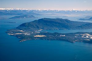
Mount Constitution is the highest point in the San Juan Islands. It is about 2,409 feet (734 meters) tall. This mountain is part of Moran State Park.
Moran State Park is the biggest public recreation area in the San Juan Islands. It is also the largest State Park in Washington. The park covers over 5,000 acres of forests. It has several lakes, including Cascade Lake, Mountain Lake, Summit Lake, and Twin Lakes. You can also find many waterfalls there.
Obstruction Pass State Park
Obstruction Pass State Park is a 76-acre park. It has more than a mile of public saltwater shoreline. This park is on the south end of Orcas Island, just south of Moran State Park.
Madrona Point
Madrona Point is a very important place for the Lummi Nation. It is a traditional burial ground. In 1890, the land was sold, which caused problems. But in 1989, the land was bought back from private owners for $2.2 million. It was then given back to the Lummi Nation.
The Lummi tribe agreed to manage the land as an open space. People and groups could visit it. However, the Lummi Nation closed the site in 2007. They did this because they felt the land was not being respected.
In Popular Culture
Orcas Island has been featured in several films and a video game.
- The 2011 film Your Sister's Sister, starring Emily Blunt, was partly filmed on Orcas Island.
- The 2022 Netflix movie Lou takes place on Orcas Island.
- The 2017 video game What Remains of Edith Finch is also set on the island.
- The book The Girl Who Wrote in Silk by Kelli Estes uses Orcas Island as its setting.
See also
 In Spanish: Isla Orcas para niños
 | Victor J. Glover |
 | Yvonne Cagle |
 | Jeanette Epps |
 | Bernard A. Harris Jr. |


