Pender Island facts for kids
Quick facts for kids
Pender Island
|
|
|---|---|
|
Island
|
|

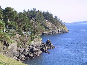
A view of North Pender Island's shoreline
|
|

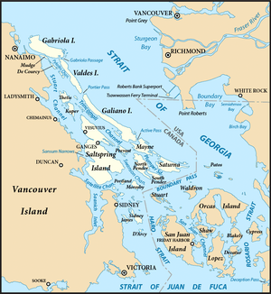
The Southern Gulf Islands, including North and South Pender.
|
|
| Country | Canada |
| Province | British Columbia |
| Area | |
| • Total | 34 km2 (13 sq mi) |
| Population | |
| • Total | 2,245 |
| Time zone | UTC−8 (PST) |
| • Summer (DST) | UTC−7 (PDT) |
Pender Island is actually two islands, North Pender and South Pender. They are part of the Southern Gulf Islands in the Salish Sea in British Columbia, Canada. The name in the Saanich language is st̕ey̕əs.
Together, the Pender Islands cover about 34 square kilometers (13 square miles). Around 2,250 people live here permanently. Many more visitors come during different seasons. Like other Southern Gulf Islands, Pender Island has a warm, dry climate. It features open farmland, rolling hills with forests, several lakes, small mountains, and many beautiful coves and beaches.
Contents
Island Geography and Features
Pender Island is made up of two separate islands: North Pender and South Pender. A narrow canal was dug between them in 1903. In 1955, a one-lane bridge was built to connect the two islands. This bridge is still used today.
Most of the people and services are on North Pender Island. The area around Magic Lake has the most people living there.
Indigenous Place Names
The Sencot'en people have special names for places on Pender Island. For example, st̕ey̕əs is the name for Pender Island itself. Other names include ʔiləčən for Bedwell Harbor and x̣ʷəl̕isən̕ for Port Browning.
Some place names on North Pender Island are:
- šxʷsəɬqʷsət (Shark Cove)
- x̣ʷəx̣ʷiʔéčsəŋ (Shingle Bay)
- kʷeqsən (Stanley Point)
- kʷeqsən (Boat Nook)
- təlasəŋ̕ (Hope Bay)
- sq̕ʷəq̕ʷiŋ̕əs (Oaks Bluff)
- q̕eʔƛ̕əŋ or sq̕eʔəƛ̕əm (Otter Bay)
- x̣ʷiʔx̣ʷnəčénəm or sx̣ʷix̣ʷθəʔ (Wallace Point)
On South Pender Island, some geographic names include:
- sk̕ʷən̕enxʷ (Gowlland Point)
- st'eyus (Bedwell Harbour)
- smanəč (Teece Point)
Island History and First Peoples
When Europeans first arrived, the Coast Salish peoples lived on Pender Island. They spoke the North Straits Salish language. There is an Indian reserve at Hay Point on South Pender Island. This reserve is home to members of the Tsawout and Tseycum First Nations.
Scientists have found very old artifacts near Shark Cove. These artifacts show that an Indigenous village has been there for about 5,000 years. The Poets Cove Resort was built on the site of an ancient First Nations village.
In 1791, a Spanish group led by Francisco de Eliza visited Pender Island. They named it "Ysla de San Eusevio." Later, Captain Richards gave the islands their current name. He named them after Staff Commander Daniel Pender, who explored the coast of British Columbia from 1857 to 1870. The first European settler arrived on South Pender Island in 1886.
Fun Activities and Culture
Pender Island is a great place for outdoor fun. People enjoy fishing, boating, and scuba diving here.
The Pender Islands Handbook is a helpful guide for visitors. It has information about hiking, biking, boating, and the island's history. It also includes a map.
The Pender Post is the local newspaper. It has been running since 1971.
The island has a 9-hole golf course. Local residents bought land in 1937 to create this course. It has been open ever since, except for a short time during World War II.
There is also a 27-hole disc golf course called Golf Island Disc Park. It is near Magic Lake. Volunteers help maintain the course. It even hosts disc golf tournaments, like the Pender Island Invitational.
Pender Island is also home to Canada's first olive grove. It is called Waterlea Farm. The owner planted 100 olive trees to make the first "Made in Canada" olive oil.
Parks and Beaches to Explore
Gulf Islands National Park Reserve offers many ways to enjoy nature. You can go boating, kayaking, hiking, camping, and watch wildlife.
- Beaumont has a challenging 1.5 km (0.9 mi) trail. It leads from the parking lot to the shoreline. The trail goes down steep paths through a thick rainforest.
- Mt. Norman has a difficult 1.5 km (0.9 mi) trail. It climbs 244 meters (801 ft) to a lookout point. From there, you can see amazing views of the San Juan Islands.
- Roe Lake has a moderate 1.5 km (0.9 mi) trail. It winds through the Shingle Bay uplands to one of the few freshwater lakes in the Southern Gulf Islands.
- At Roesland, you can visit a historic 1908 farmhouse. The Pender Islands Museum Society has restored it.
Camping on the Island
Gulf Islands National Park Reserve has two camping options on North Pender Island.
- Prior Centennial Campground has 17 sites where you can drive in. It has drinking water, toilets, picnic tables, and fire pits (when allowed). You can reserve these sites.
- Shingle Bay campground has 10 basic campsites. You can walk or kayak to these sites. They have picnic tables and toilets, but no drinking water. You can reserve these sites too.
The walk-in or boat-in sites at Beaumont on South Pender are currently closed for overnight camping. Beaumont still has 11 sites for day use. It has toilets and 15 mooring buoys for boats. There is no drinking water at Beaumont, and campfires are not allowed.
You can also find private camping at Port Browning Marina. You can drive to these sites. Tents can be set up on the large lawn by the water. Small RVs are welcome, but there are no hookups for them.
Getting Around Pender Island
You can reach Pender Island by ferry. BC Ferries offers regular service from Swartz Bay (near Victoria) and Tsawwassen (near Vancouver). Ferries also come from other southern Gulf Islands. They all dock at Otter Bay.
There are also scheduled seaplane and water taxi services. Pender Island has a unique system called "car stops." These are official spots where people can wait for a ride. You'll find posts with maps and often a chair.
Pender Island also has a helicopter pad near the main shopping area, the Driftwood Centre. Some helicopters can also land at Fire Hall #1. Bedwell Harbour is an official port of entry for sailors coming from the United States. Port Browning and Otter Bay also offer places for boats to anchor.
See also
 In Spanish: Isla Pender para niños
 | Isaac Myers |
 | D. Hamilton Jackson |
 | A. Philip Randolph |


