Kitimat facts for kids
Quick facts for kids
Kitimat
|
||
|---|---|---|
|
District municipality
|
||
| District of Kitimat | ||

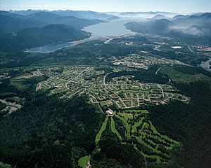
Aerial photo of Kitimat residential area with Douglas Channel in the background.
|
||
|
||
| Country | Canada | |
| Province | British Columbia | |
| Regional district | Kitimat–Stikine | |
| Area | ||
| • Total | 242.63 km2 (93.68 sq mi) | |
| Elevation | 40 m (130 ft) | |
| Population
(2016)
|
||
| • Total | 8,131 | |
| • Density | 34.7/km2 (90/sq mi) | |
| Time zone | UTC-08:00 (PST) | |
| • Summer (DST) | UTC-07:00 (PDT) | |
| Forward sortation area |
V8C
|
|
| Area code(s) | 250 / 778 / 236 | |
| Highways | ||
| Website | www.kitimat.ca | |
Kitimat is a district municipality located in the North Coast region of British Columbia, Canada. It is part of the Regional District of Kitimat–Stikine regional government. The Kitimat Valley is a busy area in northwest British Columbia, also including Terrace to the north. The town was designed and built by the Aluminum Company of Canada (Alcan) in the 1950s.
Kitimat covers an area of 242.63 km2 (93.68 sq mi). It is located right on the ocean in one of the few wide, flat valleys along the coast of British Columbia. In 2016, about 8,131 people lived there. The port of Kitimat is an important link connecting North America to the Pacific Ocean and countries around the Pacific.
Contents
History of Kitimat
The Name Kitimat
The name "Kitimat" comes from the Tsimshian language. It refers to the Haisla First Nation as the "People of the Snow." Before 1950, Kitimat was a small fishing village. It was located at the end of the Kitimat Arm of the Douglas Channel, which is a deep ocean inlet called a fjord.
Building a New Town
The modern town of Kitimat began in 1951. This happened after the government of British Columbia invited Alcan to build power plants. These plants were needed to support the aluminum industry, which uses a lot of electricity.
Alcan built a large dam, a 16 km (10 mi) tunnel, a powerhouse, and an 82 km (51 mi) power line. They also built a deep-sea port and a smelter (a factory that melts metal). The company also planned and helped build the city itself. At that time, this whole project was one of the most expensive ever done by a private company.
A Planned Community
Alcan hired a city planner named Clarence Stein. He made sure the town was designed to attract and keep workers. Even though Alcan didn't want it to be a "company town," his planning helped a lot. Kitimat still benefits from this careful planning today.
Stein's design kept the factories far away from where people lived. He also created streets that looped around a city center mall. These areas were connected by over 45 km (28 mi) of walkways. These paths linked all parts of the community. The city planners have kept Stein's ideas for large green spaces and future growth. This means Kitimat has many forested areas mixed with homes.
Economy and Industry
Main Industries
The main employer in Kitimat is Rio Tinto, which produces Aluminum. Other important jobs come from the local government, schools, small factories, and shops. Key activities also include engineering, importing oil products like methanol, and making metal items.
Major Projects
There have been big investments in manufacturing in Kitimat. For example, the Rio Tinto Alcan facilities have been modernized.
The liquefied natural gas (LNG) export project is another major development. This project, called LNG Canada, is a joint effort by companies like Shell, Petronas, Mitsubishi Corporation, Korea Gas Corporation, and PetroChina. Natural gas is piped from British Columbia and then shipped to markets in Asia. The pipeline for this project was fully installed by October 2023. The terminal, located on the Douglas Channel, is expected to start operating in 2025. It will allow large LNG ships to load gas and sail through the Douglas Channel to export destinations.
A project called the Pacific Future Energy Refinery was planned to process oil. However, this project was later stopped.
Transportation
Air travel for Kitimat is handled by the Northwest Regional Airport Terrace-Kitimat. From there, you can fly to cities like Prince George, Smithers, and Vancouver.
Kemano Hydroelectric Project
In the 1920s, the government of British Columbia looked into how much electricity could be made from water power. In the late 1940s, the Canadian government wanted to use the resources of northwest British Columbia. This led to finding the Eutsuk/Ootsa/Nechako River area as a good spot for a large water reservoir.
Alcan was looking for a place to build a big aluminum smelter, which needs huge amounts of electricity. Alcan found that the area could produce more than enough power. So, they decided to build a smelter there. This was a good time because after World War II, there was a growing demand for aluminum.
Between 1951 and 1954, Alcan started the Kitimat–Kemano Project. This was one of Canada's biggest engineering projects of the 20th century. It involved building the Kenney Dam to change the flow of the Nechako River. They also dug a 16 km (10 mi) tunnel under Mt. Dubose in the Coast Range. This tunnel led to a large hydroelectric power plant, the Kemano Generating Station, built inside Mt. Dubose.
Electricity from Kemano travels 80 km (50 mi) over mountains using a special power line. After avalanches damaged some towers, a strong cable system was built. In just three years, 6,000 construction workers built the dam, tunnel, powerhouse, power line, smelter, and the town.
The town of Kitimat was created out of an old-growth forest. Alcan invested over CA$500 million (which would be CA$3.3 billion today). They hired over 35,000 workers over five years to build everything. This included the Kenney Dam, the power plant at Kemano, an aluminum smelter, a year-round deepwater port, a town designed for 50,000 people, and a paved highway. Because of this huge project, other companies saw the potential of the area, leading to more industrial growth in the Kitimat valley.
Geography and Climate
Location
Kitimat is located 63 km (39 mi) south of Terrace and Thornhill on Highway 37. Prince Rupert is 207 km (129 mi) northwest, and Prince George is 629 km (391 mi) to the east.
Weather in Kitimat
Kitimat has a climate with warm summers and cold, snowy winters. It gets a lot of snow, about 128 inches (325 cm) each year. The rainiest time of year is fall, with October being the wettest month. There is also less rain in the summer. It is often cloudy, especially in winter.
| Climate data for Kitimat | |||||||||||||
|---|---|---|---|---|---|---|---|---|---|---|---|---|---|
| Month | Jan | Feb | Mar | Apr | May | Jun | Jul | Aug | Sep | Oct | Nov | Dec | Year |
| Record high °C (°F) | 12.2 (54.0) |
13.0 (55.4) |
18.0 (64.4) |
27.5 (81.5) |
32.8 (91.0) |
37.0 (98.6) |
41.1 (106.0) |
36.0 (96.8) |
33.3 (91.9) |
25.0 (77.0) |
13.3 (55.9) |
10.0 (50.0) |
41.1 (106.0) |
| Mean daily maximum °C (°F) | 0.5 (32.9) |
3.1 (37.6) |
6.7 (44.1) |
11.7 (53.1) |
16.2 (61.2) |
19.5 (67.1) |
21.6 (70.9) |
21.4 (70.5) |
16.8 (62.2) |
10.1 (50.2) |
3.9 (39.0) |
1.2 (34.2) |
11.1 (52.0) |
| Daily mean °C (°F) | −1.7 (28.9) |
0.3 (32.5) |
3.2 (37.8) |
7.1 (44.8) |
11.0 (51.8) |
14.5 (58.1) |
16.7 (62.1) |
16.5 (61.7) |
12.6 (54.7) |
7.2 (45.0) |
1.8 (35.2) |
−0.8 (30.6) |
7.4 (45.3) |
| Mean daily minimum °C (°F) | −4.0 (24.8) |
−2.5 (27.5) |
−0.3 (31.5) |
2.4 (36.3) |
5.7 (42.3) |
9.5 (49.1) |
11.7 (53.1) |
11.5 (52.7) |
8.3 (46.9) |
4.3 (39.7) |
−0.3 (31.5) |
−2.8 (27.0) |
3.6 (38.5) |
| Record low °C (°F) | −25.0 (−13.0) |
−23.9 (−11.0) |
−19.4 (−2.9) |
−10.0 (14.0) |
−6.7 (19.9) |
−0.6 (30.9) |
3.9 (39.0) |
2.0 (35.6) |
−2.0 (28.4) |
−13.0 (8.6) |
−24.0 (−11.2) |
−25.0 (−13.0) |
−25.0 (−13.0) |
| Average precipitation mm (inches) | 288.4 (11.35) |
186.8 (7.35) |
160.7 (6.33) |
128.3 (5.05) |
89.5 (3.52) |
73.1 (2.88) |
62.4 (2.46) |
95.7 (3.77) |
190.2 (7.49) |
323.5 (12.74) |
320.3 (12.61) |
291.8 (11.49) |
2,210.7 (87.04) |
| Average rainfall mm (inches) | 195.7 (7.70) |
133.6 (5.26) |
134.5 (5.30) |
123.0 (4.84) |
88.7 (3.49) |
73.1 (2.88) |
62.4 (2.46) |
95.7 (3.77) |
190.2 (7.49) |
319.9 (12.59) |
266.6 (10.50) |
202.7 (7.98) |
1,886.1 (74.26) |
| Average snowfall cm (inches) | 92.7 (36.5) |
53.2 (20.9) |
26.3 (10.4) |
5.4 (2.1) |
0.8 (0.3) |
0.0 (0.0) |
0.0 (0.0) |
0.0 (0.0) |
0.0 (0.0) |
3.6 (1.4) |
53.7 (21.1) |
89.1 (35.1) |
324.6 (127.8) |
| Average precipitation days (≥ 0.2 mm) | 19.7 | 15.5 | 18.5 | 17.2 | 15.8 | 14.8 | 13.2 | 13.7 | 16.9 | 22.1 | 21.7 | 21.5 | 210.5 |
| Average rainy days (≥ 0.2 mm) | 14.5 | 12.0 | 16.7 | 17.0 | 15.8 | 14.8 | 13.2 | 13.7 | 16.9 | 21.9 | 18.8 | 14.8 | 190.1 |
| Average snowy days (≥ 0.2 cm) | 9.2 | 6.3 | 5.0 | 1.2 | 0.2 | 0.0 | 0.0 | 0.0 | 0.0 | 1.0 | 7.0 | 11.4 | 41.2 |
| Mean monthly sunshine hours | 48.5 | 75.9 | 103.8 | 153.9 | 199.6 | 189.5 | 214.3 | 196.5 | 129.7 | 69.2 | 38.1 | 30.9 | 1,449.9 |
| Percent possible sunshine | 19.5 | 27.7 | 28.3 | 36.6 | 40.3 | 37.1 | 41.7 | 42.7 | 33.9 | 21.1 | 14.8 | 13.3 | 29.7 |
Population and People
Population Changes Over Time
| Historical population | ||
|---|---|---|
| Year | Pop. | ±% |
| 1991 | 11,305 | — |
| 1996 | 11,136 | −1.5% |
| 2001 | 10,285 | −7.6% |
| 2006 | 8,987 | −12.6% |
| 2011 | 8,335 | −7.3% |
In the 2021 Census, Kitimat had a population of 8,236 people. This was a small increase from its 2016 population of 8,131. The town has a land area of 239.28 km2 (92.39 sq mi).
Different Backgrounds in Kitimat
Kitimat is home to people from many different backgrounds. The largest group is people of European descent. There is also a significant number of Indigenous people. Other groups include those from Southeast Asia, South Asia, Africa, and East Asia.
| Panethnic group |
2021 | 2016 | 2011 | 2006 | 2001 | 1996 | 1991 | 1986 | |||||||||||
|---|---|---|---|---|---|---|---|---|---|---|---|---|---|---|---|---|---|---|---|
| Pop. | % | Pop. | % | Pop. | % | Pop. | % | Pop. | % | Pop. | % | Pop. | % | Pop. | % | ||||
| European | 6,285 | 76.55% | 6,555 | 81.38% | 6,950 | 83.38% | 7,595 | 84.86% | 8,895 | 86.87% | 9,780 | 88.03% | 9,645 | 85.51% | 9,690 | 87.06% | |||
| Indigenous | 1,240 | 15.1% | 940 | 11.67% | 920 | 11.04% | 755 | 8.44% | 540 | 5.27% | 545 | 4.91% | 715 | 6.34% | 530 | 4.76% | |||
| Southeast Asian | 200 | 2.44% | 105 | 1.3% | 155 | 1.86% | 115 | 1.28% | 90 | 0.88% | 65 | 0.59% | 35 | 0.31% | 30 | 0.27% | |||
| South Asian | 145 | 1.77% | 155 | 1.92% | 135 | 1.62% | 255 | 2.85% | 465 | 4.54% | 430 | 3.87% | 660 | 5.85% | 670 | 6.02% | |||
| African | 130 | 1.58% | 80 | 0.99% | 0 | 0% | 30 | 0.34% | 80 | 0.78% | 40 | 0.36% | 25 | 0.22% | 45 | 0.4% | |||
| East Asian | 95 | 1.16% | 95 | 1.18% | 120 | 1.44% | 140 | 1.56% | 105 | 1.03% | 180 | 1.62% | 165 | 1.46% | 135 | 1.21% | |||
| Latin American | 60 | 0.73% | 70 | 0.87% | 10 | 0.12% | 45 | 0.5% | 65 | 0.63% | 10 | 0.09% | 10 | 0.09% | 20 | 0.18% | |||
| Middle Eastern | 30 | 0.37% | 0 | 0% | 0 | 0% | 0 | 0% | 0 | 0% | 30 | 0.27% | 25 | 0.22% | 10 | 0.09% | |||
| Other/Multiracial | 25 | 0.3% | 55 | 0.68% | 0 | 0% | 20 | 0.22% | 0 | 0% | 15 | 0.14% | N/A | N/A | N/A | N/A | |||
| Total responses | 8,210 | 99.68% | 8,055 | 99.07% | 8,335 | 100% | 8,950 | 99.59% | 10,240 | 99.56% | 11,110 | 99.77% | 11,280 | 99.78% | 11,130 | 99.41% | |||
| Total population | 8,236 | 100% | 8,131 | 100% | 8,335 | 100% | 8,987 | 100% | 10,285 | 100% | 11,136 | 100% | 11,305 | 100% | 11,196 | 100% | |||
| Note: Totals greater than 100% due to multiple origin responses | |||||||||||||||||||
Religious Groups
According to the 2021 census, about half of Kitimat's residents do not identify with a religion. The other half mostly identify as Christian. There are also smaller groups of people who follow Islam, Hinduism, Buddhism, and Sikhism.
| Religious group | 2021 | 2011 | 2001 | 1991 | ||||
|---|---|---|---|---|---|---|---|---|
| Pop. | % | Pop. | % | Pop. | % | Pop. | % | |
| Irreligious | 4,220 | 51.4% | 3,250 | 38.97% | 2,320 | 22.66% | 2,765 | 24.51% |
| Christian | 3,690 | 44.95% | 4,950 | 59.35% | 7,435 | 72.61% | 7,775 | 68.93% |
| Muslim | 110 | 1.34% | 30 | 0.36% | 15 | 0.15% | 60 | 0.53% |
| Hindu | 45 | 0.55% | 30 | 0.36% | 100 | 0.98% | 95 | 0.84% |
| Buddhist | 35 | 0.43% | 20 | 0.24% | 15 | 0.15% | 55 | 0.49% |
| Sikh | 20 | 0.24% | 55 | 0.66% | 330 | 3.22% | 505 | 4.48% |
| Indigenous spirituality | 10 | 0.12% | 0 | 0% | N/A | N/A | N/A | N/A |
| Jewish | 0 | 0% | 0 | 0% | 0 | 0% | 10 | 0.09% |
| Other religion | 75 | 0.91% | 0 | 0% | 10 | 0.1% | 15 | 0.13% |
| Total responses | 8,210 | 99.68% | 8,340 | 100.06% | 10,240 | 99.56% | 11,280 | 99.78% |
Media and Communications
Local News
- Kitimat Northern Sentinel
- Skeena Reporter
Radio Stations
- FM 92.1 – CFNR-FM, First Nations community/ classic rock (from Terrace)
- FM 92.9 – CJFW-FM-1, country (repeats CJFW-FM, from Terrace)
- FM 97.7 – CKTK-FM, hot adult contemporary music
- FM 100.3 – CFKI-FM, CBC Radio 2 (repeats CBU-FM, from Vancouver)
- FM 101.1 – CBUK-FM, CBC Radio One (repeats CFPR, from Prince Rupert)
- FM 105.1 – CBUF-FM-5, Première Chaîne (French radio, repeats CBUF-FM, from Vancouver)
Television Channels
- Channel 3 – CFTK-TV, CTV 2 channel (from Terrace)
- DTBS cable channel 10
Notable People from Kitimat
- Benjamin Arthur – an actor
- Kayla Czaga – a poet
- Mark Fitzpatrick – a professional ice hockey goaltender
- Wayne Kelly – a swimmer who competed in the 1984 Los Angeles Olympics
- Jon Kelly – a swimmer who competed in the 1988 Seoul Olympics
- Bill Leeb – a musician and record producer
- Alison Redford – a lawyer and former Premier of Alberta
- Eden Robinson – an author
- Benjamin Thorne - a speed walker
- Bill Riley (ice hockey, born 1950) – a professional ice hockey player
- Rod Pelley – a professional ice hockey player
See also
- List of francophone communities in British Columbia
- List of Panamax ports
- Kitlope Indian Reserve No. 16
 | Charles R. Drew |
 | Benjamin Banneker |
 | Jane C. Wright |
 | Roger Arliner Young |


