Nechako River facts for kids
Quick facts for kids Nechako River |
|
|---|---|

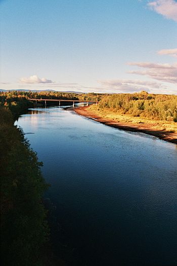
The Nechako River and Highway 16 bridge, near Fort Fraser
|
|
| Country | Canada |
| Province | British Columbia |
| City | Prince George |
| Physical characteristics | |
| Main source | Nechako Plateau |
| River mouth | Fraser River Prince George 559 m (1,834 ft) 53°55′2″N 122°42′53″W / 53.91722°N 122.71472°W |
| Length | 516 km (321 mi) |
| Basin features | |
| Basin size | 42,700 km2 (16,500 sq mi) |
The Nechako River is a major river in British Columbia, Canada. It starts on the Nechako Plateau, which is east of the Coast Mountains. The river flows north towards Fort Fraser, then turns east. It eventually joins the mighty Fraser River in Prince George.
The name "Nechako" comes from the Carrier language, an Indigenous language. In Carrier, netʃa koh means "big river." This name perfectly describes the Nechako River!
Contents
River's Many Branches
The Nechako River has several important smaller rivers, called tributaries, that flow into it.
- The Stuart River joins the Nechako about 45 kilometers (28 miles) east of Vanderhoof.
- The Endako River and the Chilako River also add their waters. The Chilako River meets the Nechako about 15 kilometers (9 miles) west of Prince George.
- The Nautley River is a short stream that flows from Fraser Lake into the Nechako.
- Another tributary is the Cheslatta River. It drains Cheslatta Lake and flows into the Nechako at the bottom of the Nechako Canyon. This happens near Cheslatta Falls and the Kenney Dam.
River History
The first European explorer to pass by the mouth of the Nechako River was Alexander MacKenzie in 1793. Interestingly, he didn't notice it! The first European to actually travel up the Nechako River was James McDougall. He was part of Simon Fraser's expedition in 1806.
Nechako Reservoir
The Nechako River is a very important branch of the Fraser River. However, about half of its water has been redirected. This water flows through the Coast Mountains to the Kemano power station. This station is at sea level on the Gardner Canal. The water drops 858 meters (2,815 feet) to power the station. The electricity generated here is used by an aluminum smelter in nearby Kitimat.
Creating the Reservoir
The main body of water for this power project is called the Nechako Reservoir. It's also known as the Ootsa Lake Reservoir. This reservoir is huge and has many different parts. It was created by joining several chains of lakes. The biggest of these lakes were Eutsuk Lake and Natalkuz Lake. These now form the southern arm of the reservoir.
The reservoir's other name comes from Ootsa Lake. This lake is now part of the northern arm of the reservoir. Originally, Ootsa Lake flowed into the Oosta River, which was a tributary of the Nechako. Other lakes that became part of the northern arm include Whitesail Lake and Tahtsa Lake. The rivers that once connected these lakes are now flooded. They are called Whitesail Reach and Tahtsa Reach. The Quanchus Range is a mountain range located between the two arms of the reservoir.
Impact of the Dam
The Nechako River was dammed in 1952. This greatly reduced the amount of water flowing in the river. This change had a big impact on the environment and local communities.
- The Cheslatta Carrier Nation, a group of the Dakelh (or Carrier) people, lived in the area. When the reservoir was created, their homes were flooded. They had to move from their traditional lands.
- The reduced water flow also caused the river's temperature to rise. This has been a problem for salmon that travel up the Fraser and Stuart Rivers, as well as the Nechako. Salmon need cool water to survive.
- Studies also suggest that populations of White Sturgeon, a large fish, might have been affected. There has been an unusual drop in the number of young adult sturgeon.
See also
 In Spanish: Río Nechako para niños
 | Stephanie Wilson |
 | Charles Bolden |
 | Ronald McNair |
 | Frederick D. Gregory |

