North Coast Regional District facts for kids
Quick facts for kids
North Coast
|
||
|---|---|---|
|
Regional district
|
||
| North Coast Regional District | ||

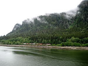
Canadian National train entering Prince Rupert
|
||
|
|
||

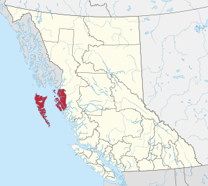
Location in British Columbia
|
||
| Country | Canada | |
| Province | British Columbia | |
| Administrative office location | Prince Rupert | |
| Government | ||
| • Type | Regional district | |
| • Body | Board of Directors | |
| Area | ||
| • Land | 19,775.41 km2 (7,635.33 sq mi) | |
| Population
(2016)
|
||
| • Total | 18,133 | |
| • Density | 0.917/km2 (2.38/sq mi) | |
| Website | ncrdbc.com | |
The North Coast Regional District is a special area in British Columbia, Canada. It's like a local government that helps manage different communities. This region is on the west coast of British Columbia. It includes the beautiful Haida Gwaii islands, which used to be called the Queen Charlotte Islands. The two biggest islands there are Graham Island and Moresby Island. The main office for the North Coast Regional District is in the city of Prince Rupert.
Contents
Quick Facts About the Region
The North Coast Regional District covers a large area of land.
- It spans about 19,775 square kilometers (7,635 square miles).
- In 2016, about 18,133 people lived here.
- The main office is in Prince Rupert.
How the Region is Organized
The North Coast Regional District is divided into smaller parts. These parts help manage the communities.
Electoral Areas
Electoral areas are places that are not part of a city or village. They are managed by the regional district.
- Area A is called Skeena North. It includes communities like Dodge Cove.
- Area C is known as Skeena South. Oona River is one community here.
- Area D covers Haida Gwaii North. This area includes rural parts of Graham Island. Some communities here are Tlell, Tow Hill, Lawn Hill, and Miller Creek.
- Area E is Haida Gwaii South. It includes communities like Sandspit.
Cities and Villages
Several towns and cities are part of the North Coast Regional District. They have their own local governments.
- City of Prince Rupert: This is the largest city in the region.
- Village of Queen Charlotte: A village located on Haida Gwaii.
- Village of Masset: Another village found on Haida Gwaii.
- District of Port Edward: A district near Prince Rupert.
- Village of Port Clements: A village also located on Haida Gwaii.
People of the North Coast
The North Coast Regional District is home to many different groups of people.
Ethnic Backgrounds
The people living here come from various backgrounds.
- Many residents are of European heritage.
- A large number of people are Aboriginal, meaning they are the original inhabitants of this land.
- There are also people from Southeast Asia, South Asia, China, and the Philippines.
- Smaller groups include people from Japan, Africa, Latin America, and West Asia.
Indigenous Communities
There are also several Indian reserve communities within the region. These communities are governed by their own band governments. Their populations are counted separately from the regional district's main numbers.
- Old Massett (Masset Indian Reserve No. 1)
- Skidegate (Skidegate Indian Reserve No. 1)
- Metlakatla
- Lax Kw'alaams (Port Simpson Indian Reserve No. 1)
Name Change History
The regional district used to have a different name.
- It was known as the Skeena-Queen Charlotte Regional District.
- This name came from the Skeena River and the Queen Charlotte Islands.
- Later, the Queen Charlotte Islands were renamed Haida Gwaii. This new name honors the Indigenous heritage of the Haida people.
- Because of this change, discussions began to update the regional district's name.
- In September 2016, the name was officially changed to the North Coast Regional District.
See also
 In Spanish: Distrito regional de Skeena-Reina Carlota para niños
 | Dorothy Vaughan |
 | Charles Henry Turner |
 | Hildrus Poindexter |
 | Henry Cecil McBay |

