
Moresby Island facts for kids
|
Gwaii Haanas (Haida)
|
|
|---|---|

Haida Gwaii. Moresby Island is the large southern island. Alaska lies north
|
|
_location_map.svg)
Moresby
Location in British Columbia
Moresby Island (British Columbia, Canada)
|
|
| Geography | |
| Location | Pacific Ocean |
| Coordinates | 52°45′00″N 131°50′00″W / 52.75°N 131.8333°W |
| Archipelago | Haida Gwaii |
| Area | 3,399.39 km2 (1,312.51 sq mi) |
| Administration | |
|
Canada
|
|
| Province | British Columbia |
| Regional District Electoral Area | North Coast Regional District Area E |
| Electoral Area Director | Evan Putterill |
| Largest settlement | Sandspit |
| Demographics | |
| Population | 402 (2006) |
| Pop. density | 0.18 /km2 (0.47 /sq mi) |


Moresby Island (also called Gwaii Haanas in the Haida language) is a big island in British Columbia, Canada. It is part of the Haida Gwaii group of islands, which used to be known as the Queen Charlotte Islands.
This island is a special place because it includes the Gwaii Haanas National Park Reserve and Haida Heritage Site. This park protects Moresby Island and many smaller islands nearby. In 2006, about 402 people lived on Moresby Island. Most of them lived in a small town called Sandspit.
Moresby Island is very large! It is the 175th biggest island in the whole world. It is also the 32nd largest island in Canada.
On October 27, 2012, a strong earthquake happened near the island. It was a magnitude 7.7 earthquake. This was the strongest earthquake in Canada since 1949.
What's in a Name?
Moresby Island got its name from a person called Rear Admiral Fairfax Moresby.
The traditional name for the island in the Haida language is Gwaii Haanas. This name is very important. It is where the name for the national park, Gwaii Haanas National Park Reserve and Haida Heritage Site, comes from.
Images for kids
-
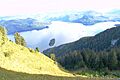
A scenic view of Tasu Mountain.

See also
 In Spanish: Isla Moresby para niños
