
Alert Bay facts for kids
Quick facts for kids
Alert Bay
|
|
|---|---|
|
Village
|
|
| The Corporation of the Village of Alert Bay | |

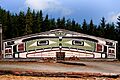
The big house near Alert Bay.
|
|

Alert Bay
Location in British Columbia

Alert Bay
Location in Canada
|
|
| Country | Canada |
| Province | British Columbia |
| Region | British Columbia Coast |
| Regional district | Mount Waddington |
| Incorporated | 1946 |
| Area
(2021)
|
|
| • Total | 1.69 km2 (0.65 sq mi) |
| Elevation
At the weather station
|
54.9 m (180.1 ft) |
| Population
(2021)
|
|
| • Total | 449 |
| • Density | 265.7/km2 (688/sq mi) |
| Time zone | UTC−08:00 (PST) |
| Highways | BC Ferries to Port McNeill and Sointula |
| Waterways | Johnstone Strait, Broughton Strait, Cormorant Channel |
| Climate | Cfb |
| Website | Village of Alert Bay |
Alert Bay is a small village located on Cormorant Island in British Columbia, Canada. It's found near Vancouver Island, close to the town of Port McNeill. This village is a special place with a rich history and strong ties to the First Nations people.
Contents
Who Lives in Alert Bay?
Alert Bay is home to about 449 people, based on the 2021 census. Many of the people living here are First Nations individuals, especially from the Kwakwakaʼwakw territory. The village is surrounded by two Indian Reserves, called Alert Bay 1 and Alert Bay 1A, which cover the rest of Cormorant Island.
What Can You Find in Alert Bay?
Alert Bay has many useful places and interesting features for its residents and visitors.
Everyday Services
The village has a credit union, a grocery store, and a post office for daily needs. You can also find a drug store, a hospital, and doctors' offices. For dining, there are four restaurants and several gift shops. There's also a pub and a Royal Canadian Legion branch.
Getting Around
Alert Bay has two airports: the Alert Bay Airport and the Alert Bay Water Aerodrome for seaplanes. There's also a boat harbour and a BC Ferries terminal. From here, you can take a ferry to nearby Sointula and Port McNeill.
Schools in the Village
Children in Alert Bay can attend Alert Bay Elementary School, which teaches kindergarten through grade 7. There's also the T'lisalagi'lakw School, run by the ʼNamgis First Nation, for nursery to grade 7 students. Older students (grades 8-12) travel by ferry or water taxi to a school in Port McNeill.
Nature and Parks
If you love nature, Alert Bay has a campground on Alder Road. You can also explore the Alert Bay Ecological Park, which used to be called Gator Gardens. This park has boardwalks over a marsh and forest trails. You'll see cedar, pine, and hemlock trees, many covered in "Witch's Hair lichen." The marsh was created when a dam was built in 1886 to collect fresh water, which flooded the area and killed some trees. The tall, dead cedar trees (called snags) are a unique sight in the marsh.
World's Tallest Totem Pole
Alert Bay is famous for being home to the world's tallest totem pole. This impressive structure is a significant cultural landmark.
U'mista Cultural Centre: A Place of History
The U'mista Cultural Centre is a very important place in Alert Bay. It tells the story of the potlatch custom of the Kwakwakaʼwakw people. In 1921, the Canadian government tried to stop the potlatch, which is a traditional ceremony involving dance, song, and sharing wealth. Many cultural items, like wooden masks and dance outfits, were taken away.
However, in the 1970s and 80s, after long talks, the Kwakwakaʼwakw people got their belongings back. These special artifacts are now kept and displayed in the museum at the U'mista Cultural Centre. It's a place where you can learn about and appreciate the rich culture and history of the Kwakwakaʼwakw.
How Alert Bay Got Its Name
The village of Alert Bay was named around 1860. It got its name from a Royal Navy ship called HMS Alert. This ship was exploring and mapping the area at that time.
What's the Weather Like?
Alert Bay has an oceanic climate, which means it's often mild and wet. It gets a lot of rain, especially in winter, because it's close to the Pacific Ocean. Snowfall is rare because winter temperatures usually stay above freezing. Summers tend to be drier.
| Climate data for Alert Bay Climate ID: 1020270; coordinates 50°35′N 126°56′W / 50.583°N 126.933°W; elevation: 59.4 m (195 ft); 1971–2000 normals |
|||||||||||||
|---|---|---|---|---|---|---|---|---|---|---|---|---|---|
| Month | Jan | Feb | Mar | Apr | May | Jun | Jul | Aug | Sep | Oct | Nov | Dec | Year |
| Record high humidex | 13.6 | 16.1 | 19.5 | 23.3 | 38.9 | 30.6 | 35.0 | 35.1 | 29.5 | 31.8 | 18.3 | 14.4 | 38.9 |
| Record high °C (°F) | 13.9 (57.0) |
16.7 (62.1) |
18.7 (65.7) |
23.5 (74.3) |
35.2 (95.4) |
30.0 (86.0) |
29.4 (84.9) |
33.3 (91.9) |
27.9 (82.2) |
23.9 (75.0) |
17.8 (64.0) |
15.6 (60.1) |
35.2 (95.4) |
| Mean daily maximum °C (°F) | 5.4 (41.7) |
6.8 (44.2) |
8.9 (48.0) |
11.3 (52.3) |
14.1 (57.4) |
15.7 (60.3) |
17.9 (64.2) |
18.2 (64.8) |
16.1 (61.0) |
11.9 (53.4) |
7.5 (45.5) |
5.6 (42.1) |
11.6 (52.9) |
| Daily mean °C (°F) | 3.5 (38.3) |
4.4 (39.9) |
5.8 (42.4) |
7.6 (45.7) |
10.1 (50.2) |
12 (54) |
14 (57) |
14.3 (57.7) |
12.3 (54.1) |
9 (48) |
5.4 (41.7) |
3.7 (38.7) |
8.5 (47.3) |
| Mean daily minimum °C (°F) | 1.5 (34.7) |
2 (36) |
2.6 (36.7) |
3.9 (39.0) |
6.1 (43.0) |
8.3 (46.9) |
10 (50) |
10.4 (50.7) |
8.4 (47.1) |
6 (43) |
3.3 (37.9) |
1.7 (35.1) |
5.4 (41.7) |
| Record low °C (°F) | −11.1 (12.0) |
−13.6 (7.5) |
−7.8 (18.0) |
−1.7 (28.9) |
0.0 (32.0) |
2.2 (36.0) |
1.1 (34.0) |
5.6 (42.1) |
1.1 (34.0) |
−3.9 (25.0) |
−12.6 (9.3) |
−13.3 (8.1) |
−13.6 (7.5) |
| Record low wind chill | −21.5 | −26.5 | −22.0 | −4.0 | 0.0 | 0.0 | 0.0 | 0.0 | 0.0 | −9.2 | −24.8 | −23.0 | −26.5 |
| Average precipitation mm (inches) | 209.2 (8.24) |
147.7 (5.81) |
125.6 (4.94) |
94.5 (3.72) |
73.7 (2.90) |
81 (3.2) |
50.5 (1.99) |
65.4 (2.57) |
91.3 (3.59) |
191.4 (7.54) |
251.5 (9.90) |
209.6 (8.25) |
1,591.5 (62.66) |
| Average rainfall mm (inches) | 189.3 (7.45) |
134.7 (5.30) |
116.7 (4.59) |
93 (3.7) |
73.7 (2.90) |
81 (3.2) |
50.5 (1.99) |
65.4 (2.57) |
91.3 (3.59) |
191 (7.5) |
244.2 (9.61) |
195.9 (7.71) |
1,526.6 (60.10) |
| Average snowfall cm (inches) | 20.7 (8.1) |
13.1 (5.2) |
8 (3.1) |
1.3 (0.5) |
0 (0) |
0 (0) |
0 (0) |
0 (0) |
0 (0) |
0.4 (0.2) |
6.6 (2.6) |
12.5 (4.9) |
62.6 (24.6) |
| Average precipitation days (≥ 0.2 mm.) | 20.5 | 18.1 | 19.5 | 17.7 | 17 | 15.6 | 12.5 | 12.5 | 14.5 | 19.8 | 22.2 | 21.7 | 211.8 |
| Average rainy days (≥ 0.2 mm.) | 18.3 | 17 | 18.8 | 17.7 | 17 | 15.6 | 12.5 | 12.5 | 14.5 | 19.7 | 21.7 | 20.4 | 205.5 |
| Average snowy days (≥ 0.2 cm) | 4.6 | 3.4 | 2 | 0.52 | 0 | 0 | 0 | 0 | 0 | 0.1 | 1.1 | 3.4 | 15.1 |
| Source: Environment and Climate Change Canada Canadian Climate Normals 1971–2000 | |||||||||||||
Geology: The Land Around Alert Bay
The land around Alert Bay has features that show it was once a place of volcanic activity. This area is part of the Alert Bay Volcanic Belt. It was active millions of years ago, during the Miocene and Pliocene periods. There haven't been any known volcanic eruptions recently, so it's likely that the volcanic activity in this area has stopped.
Notable People from Alert Bay
- Brothers Bing Chew Wong and Frank Bing Wong - These Chinese Canadian brothers grew up in Alert Bay and Vancouver. Bing was an accountant who helped many people, including Chinese and First Nations clients, with their finances. Both brothers were veterans of the Second World War.
Images for kids
-
The big house near Alert Bay.
