Great Bear Rainforest facts for kids
Quick facts for kids Great Bear Rainforest |
|
|---|---|

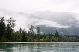
Lowland forests of Kitlope Heritage Conservancy
|
|
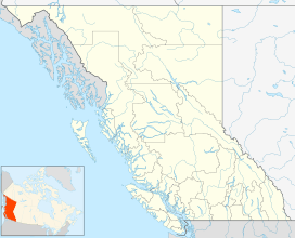
| Map | |
| Geography | |
| Location | British Columbia, Canada |
| Coordinates | 53°0′0″N 128°0′0″W / 53.00000°N 128.00000°W |
| Area | 64,000 km2 (25,000 sq mi) |
| Administration | |
| Established | 19 May 2016 |
| Ecology | |
| Ecosystem(s) | British Columbia mainland coastal forests |
The Great Bear Rainforest is a huge temperate rain forest on the Pacific coast of British Columbia, Canada. It covers about 6.4 million hectares, which is a massive area! This forest is part of the larger Pacific temperate rainforest ecoregion, which is the biggest coastal temperate rainforest in the entire world.
The government of British Columbia officially recognized the Great Bear Rainforest in February 2016. They announced an agreement to protect 85% of its ancient forests from industrial logging. Later that year, in September, the forest was also added to the Queen's Commonwealth Canopy, a special network of conservation areas.
Contents
Where is the Great Bear Rainforest?
The Great Bear Rainforest is roughly 32,000 km2 (12,000 sq mi) in size. To give you an idea, that's about the size of Belgium!
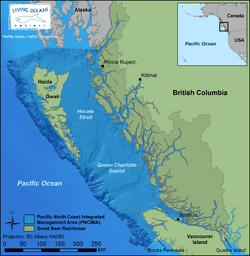
It stretches from the Discovery Islands in the south all the way to the border with Alaska in the north. It includes many islands along the coast, but not Vancouver Island or Haida Gwaii. The northern part reaches up to Portland Canal near Stewart. In the south, it includes places like Prince Rupert and parts of large channels like Douglas Channel.
The rainforest also covers areas around Dean Channel, Burke Channel, and Rivers Inlet. Important communities like Bella Bella, Bella Coola, and Hagensborg are found within this region. The very southern end includes Knight Inlet and Bute Inlet.
Amazing Animals and Plants

The Great Bear Rainforest is one of the largest untouched temperate rainforests left on Earth. It's a truly special place for wildlife.
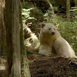
- Animals: You can find many amazing animals here, including cougars, wolves, salmon, and grizzly bears. It's also home to the unique Kermode ("spirit") bear. This is a rare type of black bear where about one in ten cubs are born with beautiful white fur.
- Trees: The forest is filled with giant, ancient trees. Some western red cedars are over 1,000 years old! There are also very tall Sitka spruce trees, which can grow up to 90 meters (about 300 feet) tall.
This type of rainforest gets a lot of rain because it's close to both the ocean and mountains. When moist air from the ocean hits the mountains, it cools down and drops a lot of rain. This weather pattern is common along the Pacific coast of North America, from Alaska down to Northern California.
How the Rainforest Was Protected
Working for Protection
In the early 1990s, environmental groups started a big campaign to protect another rainforest area in British Columbia called Clayoquot Sound. This campaign helped create a model for how to protect other forests. They used new ideas like international marketing and better mapping.
In 1997, a group of environmental organizations, including Greenpeace and Sierra Club BC, decided to call the central and northern BC coastal region the "Great Bear Rainforest." They wanted to bring attention to this special place and encourage people around the world to help protect it.
After many years of discussions and disagreements, different groups came together in May 2004. These groups included the government, many First Nations communities (like the Heiltsuk), environmental organizations, and even logging companies. They agreed to recommend that about 33% of the Great Bear Rainforest be protected. They also agreed that new, more careful ways of logging should be used in the rest of the forest.
Official Protection and Agreements
On February 7, 2006, a big agreement was announced to protect the Great Bear Rainforest. This agreement had four main parts:
- Protecting parts of the rainforest.
- Improving logging practices to be more sustainable.
- Involving First Nations in decisions about the land.
- Providing money to help local communities find new ways to make a living, besides logging.
The agreement banned logging in 33% of the Great Bear Rainforest. It also promised that by 2009, all logging in the entire area would follow "ecosystem-based management." This means managing the forest in a way that keeps the whole ecosystem healthy.
The Canadian government also promised to spend CAD$30 million to help protect the rainforest. The British Columbia government matched this amount, and private groups donated another $60 million, bringing the total funding to $120 million.
In 2008, environmental groups launched an online campaign called "Keep the Promise." They wanted to make sure the government followed through on all parts of the Great Bear Rainforest agreement.
Government Recognition and Ongoing Protection
On February 1, 2016, the Premier of British Columbia, Christy Clark, announced a new agreement. This agreement, made with First Nations, environmentalists, and the forestry industry, protects 85% of the 6.4 million hectare Great Bear Rainforest from industrial logging. The remaining 15% can still be logged, but only under very strict rules. This agreement also recognized the aboriginal rights of First Nations to share in decisions about the land. It also gave them a bigger share of timber rights and $15 million in funding for 26 First Nations in the area.
In September 2016, Prince William and Catherine, Princess of Wales, visited the forest. They unveiled a plaque to celebrate its inclusion in the Queen's Commonwealth Canopy.
Protecting the Coastline
On October 13, 2016, a tugboat carrying an empty tanker barge hit a reef near Athlone Island. This area is part of the traditional lands of the Heiltsuk First Nation and within the Great Bear Rainforest. The tugboat sank and leaked over 100,000 litres of diesel fuel into the water. This incident caused a lot of concern about protecting the rainforest's delicate environment.
Because of this and other concerns, a new law called the Oil Tanker Moratorium Act was passed on June 21, 2019. This law stops any oil tanker from docking at ports along the North Coast of British Columbia. This helps protect the Great Bear Rainforest and its waters from future spills.
 | Tommie Smith |
 | Simone Manuel |
 | Shani Davis |
 | Simone Biles |
 | Alice Coachman |


