Kitlope Heritage Conservancy facts for kids
Quick facts for kids Kitlope Heritage Conservancy |
|
|---|---|
| Huchsduwachsdu Nuyem Jees | |
|
IUCN Category Ib (Wilderness Area)
|
|

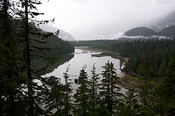
Kitlope Lake, near the centre of the conservancy
|
|
| Location | Kitimat-Stikine, British Columbia |
| Nearest city | Bella Coola |
| Area | 322,020 ha (795,700 acres) |
| Designation | Conservancy |
| Established | February 20, 1996 |
The Kitlope Heritage Conservancy is a special protected area on the Pacific coast of British Columbia, Canada. It is also known by its Haisla name, Huchsduwachsdu Nuyem Jees, which means "source of milky blue waters." This conservancy is very important because it protects the largest continuous area of coastal temperate rainforest in the entire world. It starts at the top of Gardner Canal and stretches inland along the Kitlope River all the way to Tweedsmuir Provincial Park.
A Special Place: History of Kitlope
The Kitlope River area has always been the homeland of the Haisla people. For a very long time, the Haisla used this land for hunting and fishing. They were especially known for making oolichan grease, which was a famous product along the Pacific coast.
In the early 1990s, a logging company called West Fraser Timber had plans to cut down many trees in the Kitlope area. The Haisla people, along with an environmental group called Ecotrust, worked hard to stop the logging. They talked to the company and the government to protect the watershed.
In 1994, West Fraser agreed to give up its logging rights without asking for money. After talking with the Haisla Nation, the government created a Protected Area around the Kitlope on February 20, 1996. In 2008, it was renamed a Conservancy. This new name shows that the park is now managed together by BC Parks and the Haisla people.
What is a Conservancy?
Conservancies in the park system offer a slightly different kind of protection than full Provincial Parks. They allow "low-impact" activities like eco-tourism. However, they strictly forbid heavy industries such as logging, mining, power generation, and building new roads.
The effort to protect the Kitlope valley was part of a bigger plan to save more of British Columbia's coastal temperate rainforest. This type of forest had been heavily logged in other parts of the province. The Kitlope region is now considered part of the Great Bear Rainforest, a name given by environmental groups. The Kitlope Conservancy was the first large part of the Great Bear Rainforest to be protected.
In a book called Stories from the Magic Canoe of Wa'xaid, Cecil Paul shared how the Kitlope was saved. He said, "...in our language we call it ‘Huchsduwachsdu Nuyem Jees.’ That means the land of milky blue waters and the sacred stories contained in this place. You think it's a victory because we saved the land. But what we really saved is our heritage, our stories, which are embedded in this place and which couldn't survive without it, and which contain all our wisdom for living." This shows how deeply connected the Haisla people are to their land and its history.
Exploring Kitlope's Geography
The Conservancy covers a huge area of 322,020 hectares (795,700 acres) of coastal temperate rainforest. This makes it the biggest protected area of its kind in the world! It is located at the top of the Whidbey Reach of the Gardner Canal. The conservancy includes the areas where the Kitlope, Kalitan, Gamsby, Tsaytis, Kapella, and Tezwa rivers flow.
During the spring, when snow and ice melt, these rivers can flood a lot. They carry large amounts of natural debris. Much of the park is mountainous. South of the Kitlope River, you'll find granite domes and ridges that are part of the Kitlope Range. In the north, the mountains are part of the Tochquonyalla Range. Higher up, there are also icefields and glaciers.
The valleys in the park are quite narrow, usually only one to two kilometers wide. Many valleys, like the Gamsby valley, are covered by wide, braided channels of gravel left by the rivers. The park has one main lake, Kitlope Lake. It is fed by the Tezwa River and flows into the Kitlope River near where it meets the ocean.
The Kitlope Heritage Conservancy is part of a very large continuous area of protected wilderness. Tweedsmuir Provincial Park, which is next to Kitlope in the northeast, is the biggest protected area in British Columbia. The Fiordland Conservancy protects over 80,000 hectares of coastal fjords on the western side of the Kitlope Conservancy. Together, these major parks and several smaller reserves protect over 2.3 million hectares of undeveloped land. This vast area includes many different types of natural environments.
 | Roy Wilkins |
 | John Lewis |
 | Linda Carol Brown |


