
Princess Louisa Inlet facts for kids
Quick facts for kids Princess Louisa Inlet |
|
|---|---|

Aerial view
|
|

Princess Louisa Inlet
Location in British Columbia
|
|
| Location | East side of Queens Reach, New Westminster Land District |
| Coordinates | 50°11′05″N 123°48′11″W / 50.18472°N 123.80306°W |
| Type | fjord |
| Basin countries | Canada |
| Max. length | 6 km (3.7 mi) |
| Max. depth | 179 m (587 ft) |
| Islands | Malibu Isle, MacDonald Island |
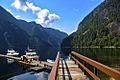
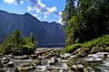
Princess Louisa Inlet is a beautiful, long, and narrow arm of the sea, also known as a fjord, located on the British Columbia Coast in Canada. It stretches for about 6 kilometers (4 miles) and is found at the northeast end of Jervis Inlet. To enter Princess Louisa Inlet, you must pass through a narrow spot called Malibu Rapids, which is near a place called Malibu. Malibu used to be a private resort but is now a camp for young people.
Part of this amazing area is protected as Princess Louisa Marine Provincial Park. Two famous waterfalls, James Bruce Falls and Chatterbox Falls, can be found here. They are fed by Loquilts Creek, a large stream that flows into the very end of the inlet.
Contents
History of Princess Louisa Inlet
In June 1792, a famous explorer named George Vancouver was mapping the British Columbia Coast. He was looking for a way to sail across North America, known as the Northwest Passage. He explored Jervis Inlet all the way to its end. It seems he found the entrance to Princess Louisa Inlet but didn't go in. This was because the tide was flowing out very strongly through Malibu Rapids at that time.
Later, in 1860, Captain George Richards surveyed and mapped both Jervis and Princess Louisa Inlets. He gave names to the inlet and the areas around it. In the same year, Commander Richard Charles Mayne explored the valley at the head of the inlet. He hoped it would lead to the interior of British Columbia.
James F. "Mac" MacDonald bought the main part of what is now the park in 1919. It was about 45 acres (18 hectares). In 1953, he generously gave this land to the Princess Louisa International Society. Then, in 1964, BC Parks took over the land to protect it. Over the years, more land around the inlet has been added to the park. An island, first called Hamilton Island and now known as MacDonald Island, is also part of the park.
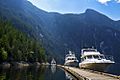
In 1940, a man named Herman Caspar sold some land at the entrance of the inlet to Thomas F. Hamilton for $500. It was later found that Caspar was a "squatter," meaning he lived on the land without owning it legally. Hamilton, who was an American aviation executive, bought all the land around Princess Louisa Inlet. He planned to build fancy resorts there for yacht owners and Hollywood stars.
However, only one resort was built, called the Malibu Club, at the entrance of the inlet. It was named after Hamilton's yacht, the Malibu. In 1950, the resort had to close and was left empty because of a polio outbreak and a quarantine. In 1953, a group called Young Life bought the property. They have successfully run it as a Christian summer camp for teenagers ever since.
How the Inlet Got its Name
The name "Princess Louisa Inlet" might come from Princess Louise. She was the fourth daughter of Queen Victoria. Her husband was the Marquess of Lorne, who was the Governor General of Canada. A Governor General is like the Queen's representative in Canada.
Princess Louise traveled a lot in Canada. She spent three months in Victoria in 1876 and was very popular. When the Governor General announced that the new transcontinental railway would go through the Selkirk Mountains to Vancouver, instead of to Victoria, the Premier of British Columbia, Robert Beaven, even asked if Vancouver Island could become a separate kingdom with Princess Louise as Queen!
However, another popular idea is that the inlet was named after Queen Victoria's mother, Princess Victoria of Saxe-Coburg-Saalfeld. Her full name was Mary Louise Victoria. So, the exact reason for the name is still a bit of a mystery.
Other nearby places are also named after royal family members. Prince of Wales Reach was named after Edward VII when he was the Prince of Wales. Princess Royal Reach was named after Empress Frederick of Germany. Five mountains around Queens Reach are named after Queen Victoria's children: Mount Victoria, Mount Alfred, Mount Alice, Mount Arthur and Mount Helena.
MacDonald Island
MacDonald Island is an island located within Princess Louisa Inlet in British Columbia. It sits between the entrance of the inlet at Malibu Rapids and the end of the inlet near Chatterbox Falls. This island is a popular spot for boats to anchor because it's one of the few shallow areas in the very deep fjord.
The island was first named after James F. MacDonald, the man who built a cabin at Chatterbox Falls. In 1940, the island's name was changed to Hamilton Island, after Thomas F. Hamilton. He was the person who built the Malibu Club and bought the land from MacDonald. But in 1972, the island's name was changed back to its original name, MacDonald Island.
How to Get There
The closest road access to Princess Louisa Inlet is about 50 kilometers (31 miles) away. You can reach it by taking a BC Ferries boat to Earls Cove on Highway 101.
The inlet is a very popular place for people who love boating. You can also get there by float plane from different places around the Strait of Georgia. Another option is to take a water taxi from Earls Cove.
Boaters should know that Malibu Rapids is a very narrow entrance. During a spring tide (when the tides are strongest), the current can flow as fast as 9 knots (17 kilometers per hour). This means you need to be careful when entering or leaving the inlet!
Images for kids
-
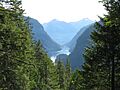
View of inlet from trappers cabin above Chatterbox Falls.
-
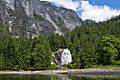
Chatterbox Falls at the head of Princess Louisa Inlet.
-
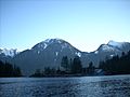
Mount Arthur rising above Malibu Club at the inlet entrance.
-
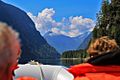
Inlet from boat.
-
Harbour
-
-
-
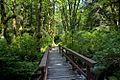
Path to the falls.
-
Stream from Chatterbox Falls.


