
Malibu Rapids (British Columbia) facts for kids
Quick facts for kids Malibu Rapids |
|
|---|---|

Malibu Rapids
Location in British Columbia
|
|

Map of the Malibu Rapids
|
|
| Location | South end of Princess Louisa Inlet, New Westminster Land District |
| Coordinates | 50°9′50.91″N 123°50′58.97″W / 50.1641417°N 123.8497139°W |
| Basin countries | British Columbia, Canada |
| Max. depth | 13 m (43 ft) |
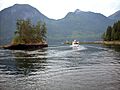
The Malibu Rapids is a special water passage that connects Princess Louisa Inlet to Jervis Inlet. It's like a narrow doorway between these two larger bodies of water.
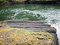
Because this passage is narrow and shallow, a lot of water moves through it very quickly. This creates strong, fast-moving "rapids" when the tide is at its strongest. The water can flow as fast as 9 kn or 17 km/h (about 17 kilometers per hour)!
But when the tide changes, there's a short time called slack tide. During this time, the water becomes almost completely calm and flat. It's similar to the Skookumchuck Narrows, another famous rapids area nearby.
Understanding the Tide
It's easy to tell which way the tide is moving at Malibu Rapids. You just need to watch the water!
- If the water is flowing out towards Jervis Inlet, it means the tide is going out. This is called a low tide.
- If the water is flowing in towards Princess Louisa Inlet, it means the tide is coming in. This is called a high tide.
Even though the Malibu Rapids can be fast, the entrance is wide enough for boats to pass through.
The narrow part of the passage is marked by a few important features:
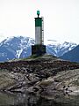
- On one side, you'll see Malibu Islet (a small island) and a special navigation buoy. This buoy helps boats know where the safe channel is.
- On the other side, near Princess Louisa Inlet, you'll find the area known as Malibu (which is also home to the Malibu Club in Canada) and the mainland shore.
Images for kids
-
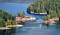
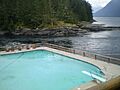
A view of the rapids from the Malibu Club.
-
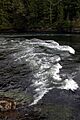
The rapids during a strong tidal flow.
-
A closer look at the moving water.
-
A navigation buoy marking the channel.
-
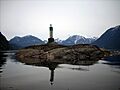
Another view of the Malibu Rapids.
-
A boat navigating through the rapids.
-
The Malibu Rapids connecting to Princess Louisa Inlet.


