
Budd Inlet facts for kids
Quick facts for kids Budd Inlet |
|
|---|---|

Looking south toward East Bay
|
|

Budd Inlet
Location in Washington (state)
|
|
| Location | Thurston County, Washington |
| Coordinates | 47°5′39″N 122°54′48.7″W / 47.09417°N 122.913528°W |
| Type | Inlet |
| Part of | South Puget Sound |
| River sources | Deschutes River |
| Ocean/sea sources | Salish Sea |
| Max. length | 6.84 mi (11.01 km) |
| Max. width | 1.86 mi (2.99 km) |
| Sections/sub-basins | West Bay, East Bay |
Budd Inlet is a narrow arm of the sea. It's found at the very southern tip of Puget Sound in Thurston County, Washington. Think of it as the southernmost 'finger' of Puget Sound.
Contents
Why is it Called Budd Inlet?
Budd Inlet got its name from Charles Wilkes. He was exploring the area during the United States Exploring Expedition. Wilkes named it after Thomas A. Budd. Thomas Budd was an important officer on two ships, the Peacock and the Vincennes. There's even a part of Antarctica, called Budd Coast, named after him too!
A Look at Its History
The shores around Budd Inlet were once home to the Steh-Chass people. They spoke the Lushootseed language. These groups later became part of the Squaxin Island Tribe.
Around the year 1850, American settlers started a city here. They named it Olympia. It was built right at the southern end of Budd Inlet.
Exploring Budd Inlet's Geography
Budd Inlet is about 6.84 miles (11.01 km) long. At its widest point, it stretches about 1.86 miles (2.99 km) across. The very southern end of Budd Inlet splits into two parts. These are called West Bay and East Bay. A piece of land divides them. This land was made wider over many years, starting in the late 1800s.
The Deschutes River flows into West Bay. This happens just north of Tumwater Falls. Before 1949, this area had wide, flat muddy shores. But in 1949, a dam was built. This created Capitol Lake, covering the mudflats.
In East Bay, a special deep channel was dug. This channel helps large ships reach the Port of Olympia.
Images for kids
-
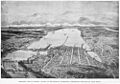
Overlooking Olympia and Budd Inlet, 1893
.jpeg)
