Port Angeles, Washington facts for kids
Quick facts for kids
Port Angeles, Washington
|
|
|---|---|
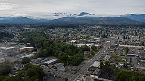
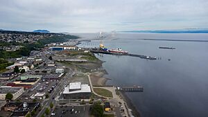
Aerial view of downtown Port Angeles, looking towards the Olympic Mountains
|
|
| Motto(s):
Where the mountains meet the sea.
|
|
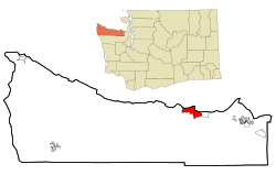
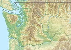
Location of Port Angeles, Washington
|
|
| Country | United States |
| State | Washington |
| County | Clallam |
| Founded | 1791 |
| Incorporated | June 11, 1890 |
| Government | |
| • Type | Council–manager |
| Area | |
| • City | 14.53 sq mi (37.63 km2) |
| • Land | 10.71 sq mi (27.74 km2) |
| • Water | 3.82 sq mi (9.89 km2) |
| Elevation | 72 ft (22 m) |
| Population
(2020)
|
|
| • City | 19,960 |
| • Estimate
(2023)
|
20,101 |
| • Density | 1,876.71/sq mi (724.61/km2) |
| • Urban | 24,445 |
| • Metro | 77,616 (US: 79th) |
| Time zone | UTC−8 (Pacific (PST)) |
| • Summer (DST) | UTC−7 (PDT) |
| ZIP Codes |
98362, 98363
|
| Area code(s) | 360 and 564 |
| FIPS code | 53-55365 |
| GNIS feature ID | 1524581 |
Port Angeles is a city in Washington, United States. It is the main city in Clallam County. In 2020, about 19,960 people lived there. It is the biggest city on the Olympic Peninsula.
The city's harbor was named "Port of Our Lady of the Angels" by a Spanish explorer in 1791. Later, the name was shortened to Port Angeles.
Port Angeles is home to Peninsula College. Famous people like football player John Elway were born here. The city has an airport and a ferry that goes to Victoria, British Columbia, Canada.
Contents
History of Port Angeles
Long ago, Native American tribes lived in this area. In 1791, a Spanish explorer named Francisco de Eliza found the harbor. He named it "Puerto de Nuestra Señora de los Ángeles," which means "Port of Our Lady of the Angels." He claimed the land for Spain. This long name was later shortened to Port Angeles.
European Americans started settling here in the 1800s. A small village grew, focused on whaling, fishing, and shipping. It traded with Victoria, British Columbia. In 1856, the first settlers arrived.
Later, a man named Victor Smith helped make Port Angeles important. He convinced President Abraham Lincoln to set aside land for federal use. The U.S. Army Corps of Engineers planned the city's streets. Because the U.S. government officially planned it, Port Angeles was called the "Second National City" in 1890.
After a quiet period, the town grew again in the 1880s. A hotel and a general store were built. By 1890, the population reached 3,000. The town became official on June 11, 1890. It was also chosen as the main city for Clallam County.
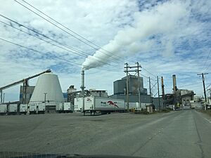
In the early 1900s, logging became a big industry. Many mills were built, and they supported the local economy for many years.
Later, tourism became important. More people visited because of the beautiful Olympic National Park. The park has mountains, rivers, and rainforests. Many mills closed in the 1970s and 1980s.
In 2003, a big construction project started near the water. Workers found human remains and old tools. This site was a very old Native American village and burial ground. It belonged to the Lower Elwha Klallam Tribe. Archeologists found about 300 graves and many artifacts. Some remains were 8,000 years old. Because the site was so important, the construction project was stopped in 2004.
Many people in the graves seemed to have died suddenly. Experts think this was due to diseases like smallpox. These diseases came with European traders. Native Americans had no protection against them. This caused many deaths long ago.
In 2016, Port Angeles put up street signs in both English and the Klallam language. This helps keep the local Klallam culture alive.
Geography and Climate
Port Angeles is located at 48°07′5.33″N 123°25′50.67″W / 48.1181472°N 123.4307417°W.
The city covers about 14.5 square miles (37.6 square kilometers). Most of this is land, with some water.
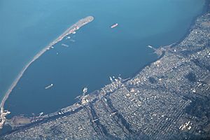
Port Angeles is on the northern edge of the Olympic Peninsula. It sits along the shore of the Strait of Juan de Fuca. A long, narrow piece of land called Ediz Hook stretches into the Strait. This hook creates a natural deep-water harbor. It protects the harbor from storms. Large ships, like tankers and cruise ships, can anchor here. You can see Vancouver Island and the city of Victoria, British Columbia across the Strait.
Port Angeles is in the "rain shadow" of the Olympic Mountains. This means it gets much less rain than other parts of western Washington. It gets about 25 inches (635 mm) of rain each year. Seattle, for example, gets about 38 inches (965 mm). The ocean keeps temperatures mild. Winters are rarely below 25°F (-4°C). Summers are rarely above 80°F (27°C).
Port Angeles is also where the main office for Olympic National Park is located. This park protects most of the Olympic Mountains. President Franklin D. Roosevelt created the park in 1938.
Climate
Port Angeles has a warm summer mediterranean climate. This means it has cool summers and mild winters. The Pacific Ocean makes the weather very steady. Summers are cooler than in nearby Seattle. The highest temperature ever recorded was 97°F (36°C) on June 27, 2021.
| Climate data for Port Angeles, Washington (William R. Fairchild International Airport), 1991–2020 normals, extremes 1998–present | |||||||||||||
|---|---|---|---|---|---|---|---|---|---|---|---|---|---|
| Month | Jan | Feb | Mar | Apr | May | Jun | Jul | Aug | Sep | Oct | Nov | Dec | Year |
| Record high °F (°C) | 69 (21) |
69 (21) |
68 (20) |
77 (25) |
86 (30) |
97 (36) |
94 (34) |
94 (34) |
88 (31) |
78 (26) |
67 (19) |
60 (16) |
97 (36) |
| Mean maximum °F (°C) | 56.2 (13.4) |
54.4 (12.4) |
58.8 (14.9) |
66.5 (19.2) |
73.4 (23.0) |
81.2 (27.3) |
82.8 (28.2) |
84.8 (29.3) |
78.7 (25.9) |
66.8 (19.3) |
59.0 (15.0) |
54.4 (12.4) |
87.3 (30.7) |
| Mean daily maximum °F (°C) | 45.3 (7.4) |
46.6 (8.1) |
49.8 (9.9) |
54.2 (12.3) |
59.5 (15.3) |
63.4 (17.4) |
68.2 (20.1) |
69.7 (20.9) |
66.1 (18.9) |
56.7 (13.7) |
49.4 (9.7) |
44.8 (7.1) |
56.1 (13.4) |
| Daily mean °F (°C) | 39.2 (4.0) |
39.8 (4.3) |
42.4 (5.8) |
46.5 (8.1) |
51.5 (10.8) |
55.4 (13.0) |
59.7 (15.4) |
60.4 (15.8) |
56.6 (13.7) |
49.2 (9.6) |
42.7 (5.9) |
39.1 (3.9) |
48.5 (9.2) |
| Mean daily minimum °F (°C) | 33.1 (0.6) |
33.0 (0.6) |
35.0 (1.7) |
38.8 (3.8) |
43.4 (6.3) |
47.4 (8.6) |
51.1 (10.6) |
51.1 (10.6) |
47.1 (8.4) |
41.6 (5.3) |
36.0 (2.2) |
33.4 (0.8) |
40.9 (5.0) |
| Mean minimum °F (°C) | 23.3 (−4.8) |
23.7 (−4.6) |
27.5 (−2.5) |
31.2 (−0.4) |
35.5 (1.9) |
40.8 (4.9) |
45.4 (7.4) |
45.1 (7.3) |
39.8 (4.3) |
31.9 (−0.1) |
25.6 (−3.6) |
22.7 (−5.2) |
18.1 (−7.7) |
| Record low °F (°C) | 12 (−11) |
11 (−12) |
18 (−8) |
28 (−2) |
31 (−1) |
36 (2) |
41 (5) |
42 (6) |
33 (1) |
22 (−6) |
11 (−12) |
13 (−11) |
11 (−12) |
| Average precipitation inches (mm) | 4.29 (109) |
2.84 (72) |
2.94 (75) |
1.65 (42) |
1.17 (30) |
0.73 (19) |
0.46 (12) |
0.64 (16) |
1.29 (33) |
3.06 (78) |
5.11 (130) |
5.23 (133) |
29.41 (749) |
| Average snowfall inches (cm) | 0.0 (0.0) |
0.0 (0.0) |
0.0 (0.0) |
0.0 (0.0) |
0.0 (0.0) |
0.0 (0.0) |
0.0 (0.0) |
0.0 (0.0) |
0.0 (0.0) |
0.0 (0.0) |
0.0 (0.0) |
0.4 (1.0) |
0.4 (1) |
| Average precipitation days (≥ 0.01 in) | 17.4 | 13.4 | 15.6 | 11.9 | 10.1 | 7.6 | 3.9 | 5.5 | 9.0 | 13.7 | 17.4 | 16.7 | 142.2 |
| Average snowy days (≥ 0.1 in) | 0.0 | 0.0 | 0.0 | 0.0 | 0.0 | 0.0 | 0.0 | 0.0 | 0.0 | 0.0 | 0.0 | 0.2 | 0.2 |
| Average relative humidity (%) | 88 | 87 | 86 | 83 | 79 | 79 | 75 | 76 | 80 | 83 | 86 | 88 | 83 |
| Mean daily sunshine hours | 4.1 | 4.2 | 5.8 | 7.8 | 9.2 | 9.7 | 10.8 | 10.8 | 9.2 | 5.5 | 4.9 | 4.5 | 7.2 |
| Mean daily daylight hours | 8.9 | 10.3 | 12.0 | 13.7 | 15.2 | 16.0 | 15.6 | 14.2 | 12.5 | 10.8 | 9.2 | 8.4 | 12.2 |
| Average ultraviolet index | 2 | 2 | 2 | 3 | 3 | 4 | 4 | 4 | 3 | 3 | 2 | 2 | 3 |
| Source 1: NOAA | |||||||||||||
| Source 2: Weather Atlas (UV and humidity) | |||||||||||||
People and Population
| Historical population | |||
|---|---|---|---|
| Census | Pop. | %± | |
| 1900 | 2,321 | — | |
| 1910 | 2,286 | −1.5% | |
| 1920 | 5,351 | 134.1% | |
| 1930 | 10,188 | 90.4% | |
| 1940 | 9,409 | −7.6% | |
| 1950 | 11,233 | 19.4% | |
| 1960 | 12,653 | 12.6% | |
| 1970 | 16,367 | 29.4% | |
| 1980 | 17,311 | 5.8% | |
| 1990 | 17,710 | 2.3% | |
| 2000 | 18,397 | 3.9% | |
| 2010 | 19,038 | 3.5% | |
| 2020 | 19,960 | 4.8% | |
| 2023 (est.) | 20,101 | 5.6% | |
| U.S. Decennial Census 2020 Census |
|||
In 2022, there were about 9,087 homes in Port Angeles. Each home had about 2.15 people. The average income for a household was about $60,212. About 11% of the people in the city lived below the poverty line. Most adults (92.9%) had a high school diploma. About 30.7% had a college degree or higher.
The main backgrounds of people in Port Angeles include English, Spanish, Native American, and Asian. The average age in the city was 41.3 years old.
Population Details (2020)
| Race / ethnicity (NH = non-Hispanic) | Pop. 2000 | Pop. 2010 | Pop. 2020 | % 2000 | % 2010 | % 2020 |
|---|---|---|---|---|---|---|
| White alone (NH) | 16,572 | 16,456 | 16,092 | 90.08% | 86.44% | 80.62% |
| Black or African American alone (NH) | 123 | 153 | 155 | 0.67% | 0.80% | 0.78% |
| Native American or Alaska Native alone (NH) | 562 | 578 | 595 | 3.05% | 3.04% | 2.98% |
| Asian alone (NH) | 238 | 329 | 416 | 1.29% | 1.73% | 2.08% |
| Pacific Islander alone (NH) | 32 | 30 | 39 | 0.17% | 0.16% | 0.20% |
| Other race alone (NH) | 9 | 26 | 91 | 0.05% | 0.14% | 0.46% |
| Mixed race or multiracial (NH) | 431 | 699 | 1,457 | 2.34% | 3.67% | 7.30% |
| Hispanic or Latino (any race) | 430 | 767 | 1,115 | 2.34% | 4.03% | 5.59% |
| Total | 18,397 | 19,038 | 19,960 | 100.00% | 100.00% | 100.00% |
In 2020, there were 19,960 people living in Port Angeles. About 8,883 households and 4,955 families were in the city. The population density was about 1,863 people per square mile.
Most people (82.73%) were White. Other groups included African American, Native American, Asian, and Pacific Islander. About 5.59% of the population was Hispanic or Latino.
About 18.6% of residents were under 18 years old. About 22.4% were 65 or older. The city had slightly more males (50.2%) than females (49.8%).
Media and Entertainment
Newspapers
The local newspaper is the Peninsula Daily News. It started in 1916 as the Port Angeles Evening News. It prints six days a week and has a website for the North Olympic Peninsula.
Radio
Newsradio 1450 KONP is a local radio station. It shares news, sports, and talk shows on AM 1450 and FM 101.7. The Strait 102 KSTI is an FM radio station that plays country music on FM 102.1.
Television and Movies
Port Angeles is home to Rygaard Logging. This logging company was featured on the TV show Ax Men on the History Channel.
The Strait of Juan de Fuca near Port Angeles was used for filming scenes in the 1990 movie The Hunt for Red October. The last scene of the 1994 movie Wyatt Earp was also filmed here. It showed Wyatt and Josie on a boat with the Olympic Mountains in the background.
Education in Port Angeles
Public schools in Port Angeles are run by the Port Angeles School District. There are five elementary schools, one middle school, and a high school. There is also an alternative high school and a vocational school.
Two private schools, Queen of Angels Catholic School and Olympic Christian School, serve students from kindergarten to 8th grade.
Peninsula College is a community college located in Port Angeles. It serves students from all over the Olympic Peninsula.
Sister City
Port Angeles has a sister city in Japan called Mutsu, Aomori. The two cities have a student exchange program. This allows students to visit and learn about each other's cultures.
Notable People from Port Angeles
- Robin Alexis, a radio personality
- Scott Bower, former soccer player
- Raymond Carver, a famous author
- Casey Crescenzo, a musician
- Matthew Dryke, an Olympic gold medalist in shooting
- John Elway, a famous football player for the Denver Broncos
- Bernie Fryer, a former basketball player and NBA referee
- Tess Gallagher, an author
- Patrick Haggerty, a country singer
- Derek Kilmer, a U.S. Congressman
- Sean Mac Falls, a poet
- Ellie Mathews, a children's writer
- Jim Michalczik, a football coach and former NFL player
- Robert Hopkins Miller, a diplomat
- Jeff Ridgway, a former Major League Baseball player
- Arnie Roblan, a politician
- Bryan Suits, a radio host and podcaster
See also
 In Spanish: Port Angeles para niños
 | Chris Smalls |
 | Fred Hampton |
 | Ralph Abernathy |


